

North Carolina map
Durham County map
About 343,628 people live here (Census Bureau, 2024 estimate). The sheet's index lists 98 streets; Guess Road, Durham Freeway and Wake Forest Highway cross the most grid squares. Things to do inside the boundary: Duke University Chapel.
Open the map (PDF, US Letter)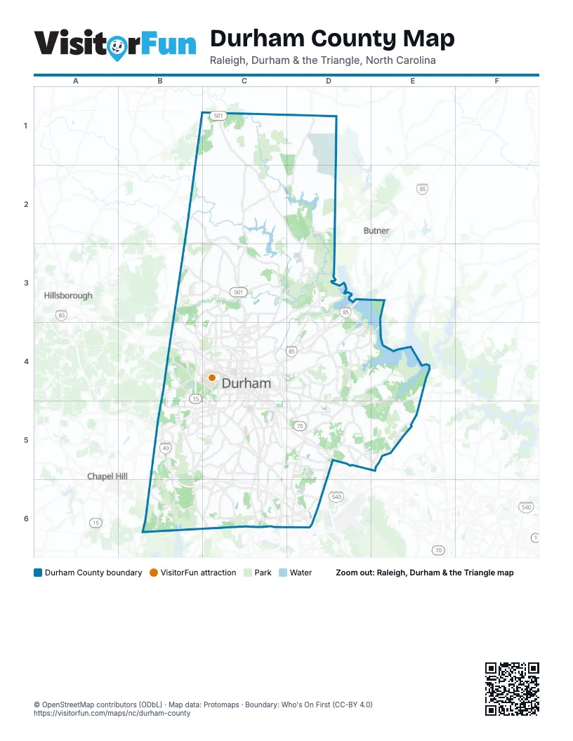
Maps inside Durham County
1 map inside, from the street map of Durham County down.
Street index of Durham County
Each street on the sheet and the grid squares it crosses.
- Roxboro RoadC1, C2, C3
- Guess RoadB2, C2, C3, C4
- North Duke StreetC3, C4
- North Roxboro StreetC3, C4
- Coach K HighwayB4, C4
- Durham FreewayB4, C4, C5, C6
- Erwin RoadB4, C4
- Hillsborough RoadB4, C4
- 9th StreetC4
- Academy RoadC4, C5
- Angier AvenueC4, C5, D5
- Avondale DriveC4
- Broad StreetC4
- Cheek RoadC4
- Dr John H Franklin HighwayC4
- Duke University RoadC4
- East Chapel Hill StreetC4
- East Geer StreetC4, D4
- East Lakewood AvenueC4
- East Main StreetC4
- East Markham AvenueC4
- East Morgan StreetC4
- East Peabody StreetC4
- Fayetteville RoadC4, C5, C6
- Fulton StreetC4
- Hillandale RoadC4
- Holloway StreetC4, D4
- I-85 North Access RoadC4
- I-85 South Access RoadC4
- Jackie Robinson DriveC4
- Liberty StreetC4
- Mangum-Roxboro ConnectorC4
- Morehead AvenueC4
- North Alston AvenueC4
- North Elizabeth StreetC4
- North Great Jones StreetC4
- North Gregson StreetC4
- North Mangum StreetC4
- North Miami BoulevardC4
- North Pointe DriveC4
- Parker StreetC4
- Ramseur StreetC4
- South Alston AvenueC4, C5
- South Duke StreetC4
- South Great Jones StreetC4
- South Gregson StreetC4
- South Mangum StreetC4
- South Roxboro StreetC4
- Swift AvenueC4
- Trent DriveC4
- University DriveC4, B5, C5
- Vickers AvenueC4
- West Carver StreetC4
- West Chapel Hill StreetC4
- West Club BoulevardC4
- West Lakewood AvenueC4
- West Main StreetC4
- West Morgan StreetC4
- Glenn School RoadD4
- Red Mill RoadD4
- Wake Forest HighwayD4, E4, D5, E5
- Durham-Chapel Hill BoulevardB5, C5
- Farrington RoadB5
- Hope Valley RoadB5, C5
- Martin Luther King Jr ParkwayB5, C5
- NC Highway 751B5, B6, C6
- Old Chapel Hill RoadB5
- Old Durham RoadB5
- Raleigh RoadB5, B6
- Southwest Durham DriveB5
- State Highway 54B5, C5
- Tower BoulevardB5
- Apex HighwayC5, C6
- East Cornwallis RoadC5, C6, D6
- East End ConnectorC5, D5
- Ellis RoadC5, D5
- Riddle RoadC5
- T.W. Alexander DriveC5, D5, C6
- Andrews Chapel RoadD5
- Brier Creek ParkwayD5
- Carpenter Pond RoadD5, E5
- Glenwood AvenueD5
- Leesville RoadD5, E5
- New Raleigh HighwayD5
- Page RoadD5, D6
- Sherron RoadD5
- South Miami BoulevardD5, D6
- Hickory Grove Church RoadE5
- Hickory Grove RoadE5
- Davis DriveC6
- Hopson RoadC6, D6
- Triangle ExpresswayC6
- Airport RoadD6
- Chapel Hill RoadD6
- Emperor BoulevardD6
- Globe RoadD6
- Northern Wake ExpresswayD6
- Slater RoadD6
Things to do on the Durham County map
Places on the map
- 11-foot-8 Bridge
- 55 at the Park
- 751 South
- 9th Street District
- Abercromby
- Abron Drive
- American Village
- Anderson St. / Wrightwood Park
- Andrews Chapel
- Archer Woods
- Arrowhead
- Artisan at Brightleaf
- Ascend Brightleaf
- Ashfield Place
- Ashworth
- Auburn Hills
- Auburn Park
- Auburn Square
- Audubon Park
- Bahama
- Bailey Lake
- Barclay to Sandlewood
- Beaver Marsh Preserve
- Beech Lake
- Belgreen
- Bennett Place
- Bennington
- Black Horse Run
- Bluff Waterfowl Impoundment
- Bon Air Avenue
- Bradbury Glen
- Bradbury Trace
- Braggtown
- Breedlove
- Briar Creek
- Brier Creek Townhomes
- Brightleaf at the Park
- Brighton Station
- Brooks Mill
- Burch Avenue
Next to Durham County
- Butner
- Chapel Hill
- Hillsborough
© OpenStreetMap contributors (ODbL) · Map data: Protomaps · Boundary: Who's On First (CC-BY 4.0)