

North Carolina map
Forsyth County map
About 398,143 people live here (Census Bureau, 2024 estimate). The sheet's index lists 172 streets; South Main Street, John Gold Memorial Expressway and University Parkway cross the most grid squares. Also on it: Aldbrige, Aquilla Islands Preserve and Ardmore.
Open the map (PDF, US Letter)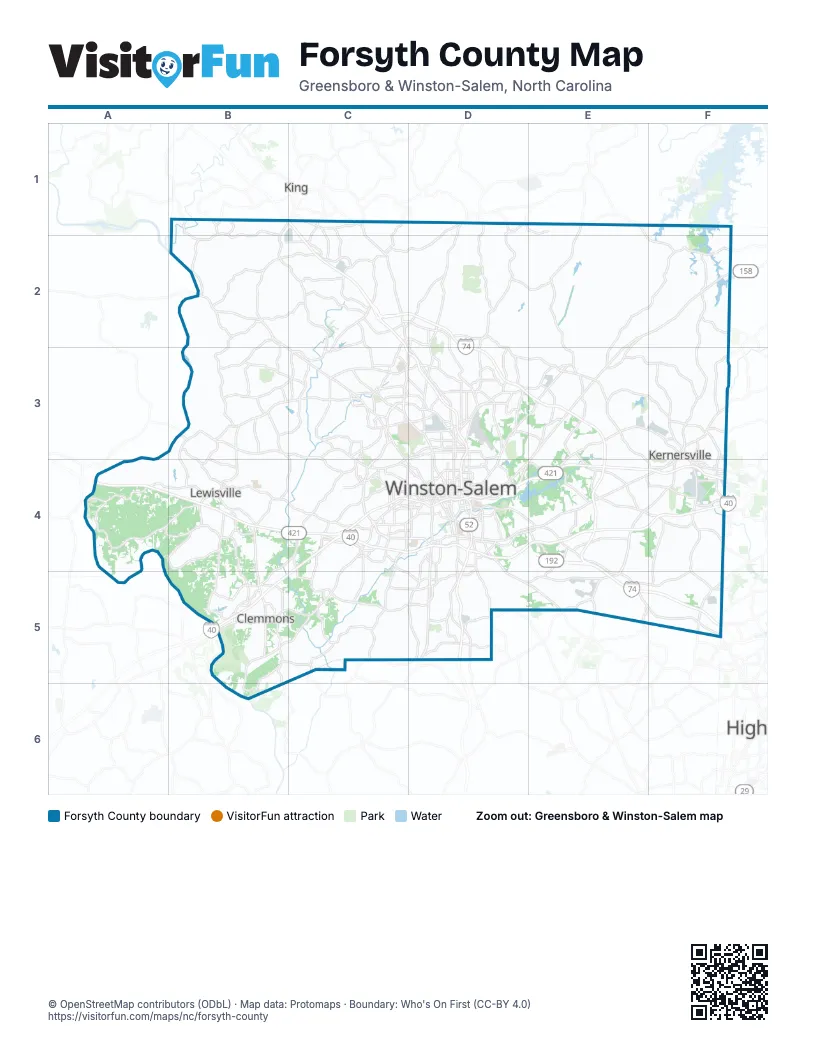
Maps inside Forsyth County
1 map inside, from the street map of Forsyth County down.
Street index of Forsyth County
Each street on the sheet and the grid squares it crosses.
- King-Tobaccoville RoadB1, B2
- South Main StreetB1, C1, F3, D4, E4, F4, D5
- Broad StreetC1, C2
- Old US Hwy 52C1
- State Highway 66 SouthC1
- Germanton RoadD1, D2, D3
- Rural Hall-Germanton RoadD1, C2, D2
- Walnut Cove RoadE1, E2, E3
- Doral DriveB2, C2
- NC Highway 67B2
- Reynolda RoadB2, C3, C4, D4
- Bethania Rural Hall RoadC2, C3
- Bethania Tobaccoville RoadC2
- East Hanes Mill RoadC2, D2
- Forum ParkwayC2
- Griffin RoadC2
- John Gold Memorial ExpresswayC2, C3, D3, D4, D5
- Main StreetC2, C3, E3
- Old Hollow RoadC2, D2, D3, E3
- Stanleyville DriveC2, D2
- Tobaccoville RoadC2
- University ParkwayC2, D2, C3, D3, D4
- West Hanes Mill RoadC2
- Westinghouse RoadC2
- Winston-Salem Northern BeltwayC2, D2, D3, E3, E4
- Baux Mountain RoadD2, D3
- Belews Creek RoadE2, F2, E3
- Reidsville RoadE2, F2, E3, D4, E4
- Piney Grove RoadF2, F3
- Meadowlark DriveB3, C3, B4, C4
- Robinhood RoadB3, C3, C4
- Yadkinville RoadB3, C3
- Bethabara Park BoulevardC3
- Bethabara Park Boulevard NorthwestC3
- Bethabara RoadC3
- Bethania RoadC3
- Coliseum Drive NorthwestC3, D3, C4
- Fairlawn DriveC3
- Indiana AvenueC3, D3
- Long RoadC3
- North Point BoulevardC3, D3
- Oak Summit RoadC3, D3
- Peace Haven Road NorthC3, C4
- Polo RoadC3, D3
- Shattalon DriveC3
- Silas Creek ParkwayC3, C4, D4
- Wake Forest RoadC3
- Yadkinville Road NorthwestC3
- Akron DriveD3
- Carver School RoadD3
- Indiana Ave.D3
- Leo StreetD3
- Motor RoadD3
- New Walkertown Road NortheastD3, E3, D4
- North Cherry StreetD3, F3
- North Cherry Street NorthwestD3
- North Liberty StreetD3, D4
- North Patterson AvenueD3, D4
- Old Rural Hall RoadD3
- Old Walkertown RoadD3, E3
- Reynolds BoulevardD3
- West 27th StreetD3
- Darrow RoadE3
- Harley DriveE3
- Hastings Hill RoadE3, E4
- Hopkins RoadE3, F4
- West Mountain StreetE3, F3, E4
- East Bodenhamer StreetF3, F4
- East Mountain StreetF3, F4
- Kernersville LoopF3
- Macy Grove Rd.F3
- Macy Grove RoadF3, F4
- North Main StreetF3, D4, F5
- Oak Ridge RoadF3
- South Cherry StreetF3, F4
- West Bodenhamer StreetF3
- Country Club RoadB4, C4, D4
- Lewisville Clemmons RoadB4, B5
- Shallowford RoadB4
- South Peace Haven RoadB4, C4, B5
- Styers Ferry RoadB4
- Williams RoadB4
- Ebert RoadC4, C5
- Ebert Road SouthwestC4, C5
- Ebert StreetC4
- Hanes Mall BoulevardC4
- Jonestown RoadC4, C5
- Knollwood StreetC4
- Robinhood Road NorthwestC4
- Salem ParkwayC4, D4, E4, F4
- South Hawthorne RoadC4, D4
- South Stratford RoadC4, D4, B5, C5
- Stratford Road NorthC4, D4
- Tiseland Drive NorthwestC4
- Broad Street NorthD4
- Cherry Street NorthD4
- Cherry Street SouthD4
- City Yard DriveD4
- Cloverdale AvenueD4
- Cloverdale Avenue NorthwestD4
- East 11th StreetD4
- East 14th StreetD4
- East 1st StreetD4
- East 3rd StreetD4
- East 5th StreetD4
- East Clemmonsville RoadD4, D5
- East Salem AvenueD4
- East Sprague StreetD4
- Fayetteville Street SoutheastD4
- Glendale StreetD4
- Hawthorne Road NorthD4
- High Street SouthwestD4
- Lockland AvenueD4
- Lowery CourtD4
- Lowery StreetD4
- Marshall Street NorthD4
- Marshall Street SouthD4
- Miller StreetD4
- North Broad StreetD4
- North Frontage RoadD4
- North Martin Luther King Jr DriveD4
- North Research ParkwayD4
- Northwest BoulevardD4
- Old Greensboro RoadD4, E4
- Old Lexington RoadD4
- Old Salem RoadD4
- Old Salisbury RoadD4, D5
- Old Salisbury Road SouthwestD4
- Old Stadium DriveD4
- Peters Creek ParkwayD4, D5
- Rams DriveD4
- Research ParkwayD4
- Reynolda Road NorthwestD4
- Reynolds Park RoadD4, E4
- Salem Ave WestD4
- Salem Avenue WestD4
- South Frontage RoadD4
- South Liberty StreetD4
- South Martin Luther King Jr DriveD4
- South Martin Luther King Junior Drive SoutheastD4
- Thomasville RoadD4, D5, E5
- Thomasville Road SoutheastD4
- Vargrave StreetD4
- Waughtown StreetD4, E4
- West 1st StreetD4
- West 2nd StreetD4
- West 3rd StreetD4
- West 4th StreetD4
- West 5th StreetD4
- West 8th StreetD4
- West Cemetery StreetD4
- West Northwest BoulevardD4
- High Point RoadE4, E5, F5
- Kernersville RoadE4
- Linville RoadE4
- Linville Road SoutheastE4
- Ridgewood RoadE4, E5
- Union Cross RoadE4, F4, D5, E5
- Kernersville Medical ParkwayF4
- Market View DriveF4
- Old Winston RoadF4
- Salisbury StreetF4
- Clemmons RoadB5
- Hampton RoadB5, B6
- Harper RoadB5
- Idols RoadB5, C5
- Kinnamon RoadB5
- West Clemmonsville RoadC5, D5
- Stafford Village BoulevardD5
- Gumtree RoadE5
- Wallburg RoadE5
- Horneytown RoadF5
Places on the map
- Aldbrige
- Aquilla Islands Preserve
- Ardmore
- Arnold Lake
- Asbury Place
- Ashley Forest Residential Area
- Avenbury Circle
- Bashavia Creek Preserve
- Bethania
- Bethania Wetlands
- Bolton Park
- Brandmere Apartments
- British Woods
- Brookberry Farm
- Brookberry Park Apartments
- C. G. Hill Memorial Park
- Caterpillar, Inc
- Century Park Plaza
- Chamblin Place
- Chandler Pointe
- Civitan Park
- Clemmons
- Clemmons Town Center
- Clemmons Trace Village
- Clemmons West
- Conrad Farm
- Conrad Lake
- Countryside Villa
- Durham Lake
- East Forsyth High School
- Enclave at North Point
- Etta Lea & Lawrence Pope Memorial Park
- Evergreen Cemetery
- Fair Oaks
- Fairmont
- Forest Hills Estates
- Forsyth Country Club
- Forsyth Country Day School
- Forsyth County
- Forsyth Medical Center
Next to Forsyth County
- King
© OpenStreetMap contributors (ODbL) · Map data: Protomaps · Boundary: Who's On First (CC-BY 4.0)