

New Hampshire map
Carroll County map
About 52,580 people live here (Census Bureau, 2024 estimate). The sheet's index lists 300 streets; White Mountain Highway, Main Street and Camp Road cross the most grid squares. Things to do inside the boundary: Castle in the Clouds, Conway Scenic Railroad and Crawford Notch State Park.
Open the map (PDF, US Letter)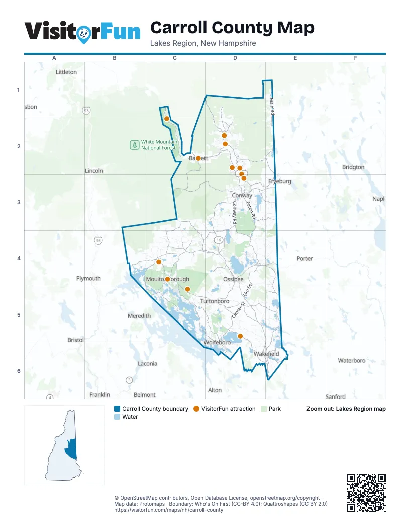
Street index of Carroll County
Each street on the sheet and the grid squares it crosses.
- White Mountain HighwayD2, D3, D4, D5, E5, D6, E6
- Crawford Notch RoadC1, C2, D2
- Whittier HighwayC4, C5
- Center StreetD5, D6
- Pinkham Notch RoadD1, D2
- Main StreetC2, D2, D3, E3, C4, D4
- East Main StreetD3, E3
- Ossipee TrailD4, E4
- White Mountain RoadD1, D2, D3
- Ossipee Mountain HighwayC4, D4
- Whittier RoadC4, D4
- Eastman RoadD3
- South Main StreetD5, D6
- Porter RoadE4
- Bear Camp HighwayC4
- Chocorua Mtn HighwayD3, D4
- Route 302C2
- West Main StreetD3
- State Route 28D6
- Old White Mountian HighwayE6
- State Route 25C4
- Old Goodrich Falls RoadD2
- Province Lake RoadE4, E5, E6
- Governor John Wentworth HighwayC4, C5, D5
- Eaton RoadD3, D4, D5
- Kancamagus HighwayC3, D3
- Mountain RoadC4, C5, D5
- Pine Hill RoadD3, C4, D4, D5
- Main RoadE1, E2
- Middle RoadC4, D4, C5, D5, E5
- State Route 113AC3, C4
- East Conway RoadE2, D3, E3
- Wakefield RoadE5, D6, E6
- Green Mountain RoadD4
- Lovell Lake RoadE6
- Wentworth RoadD5, D6
- Plains RoadD3, D4
- Conway RoadD3
- Holderness RoadB4, C4
- Elm StreetD4, E4, D5
- Water Village RoadD5
- North Main StreetC5, D5, D6
- Old Mountain RoadC4, C5
- North Sandwich RoadC4
- Chocorua RoadC4, D4
- Whiteface RoadC4
- Beede Flats RoadC4
- Wentworth Hill RoadD2, C4
- Chase RoadC3, C4
- Bunker Hill RoadC4
- Tamworth RoadC4, D4
- Deer Hill RoadE1, D3, D4
- Village RoadD3
- Holland StreetC4
- River StreetC2, D3, E3, D5
- Old Granite RoadD5
- Maple StreetD2, C4, D4, E6
- Skinner StreetC4
- Jackman Pond RoadC4
- Chinook TrailC4
- Meadow StreetD6, E6
- Pleasant StreetD3, D5, D6
- Silver Lake RoadD4
- Courthouse SquareD5
- Middleton Hill RoadE6
- Stow RoadE1
- State Route 153E5, E6
- State Route 109E6
- West Side RoadD2, D3
- Bear Notch RoadC2, C3
- Brownfield RoadD3, E3
- Green Hill RoadD2, E2
- Hurricane Mountain RoadD2, E2
- Granite RoadD5, E5
- Moultonborough Neck RoadC5
- Carter Notch RoadD1, D2
- Bean RoadD3, B4, C4, C5
- Chickville RoadD4, D5
- Browns Ridge RoadD5
- East Madison RoadD3, D4
- Squam Lake RoadB4, C4
- North-South RoadD2, D3
- Black Mountain RoadD2, D3
- Governors RoadD6, E6
- River RoadC2, D2, E5
- State Route 16BD4
- Witchtrot RoadE6
- Pork Hill RoadD5
- Kearsarge RoadD2
- Moody Farm RoadD2
- Pick Pocket RoadE5
- Washington StreetD2, D3, D4
- Moultonville RoadD4
- Mill StreetD2, D3, D5, D6
- East Side RoadD3, E6
- Dore StreetD4
- Mountain Valley BoulevardD3
- Folsom RoadD4
- Hampshire RoadE3, D4
- South Chatham RoadE2
- Chatham RoadE2
- Ossipee Lake RoadD4
- Passaconaway RoadD3, D4
- Sandwich Notch RoadB4
- Ossipee Mountain RoadC4, D4
- Stoneham RoadD5, E6
- Dundee RoadD2
- Great Hill RoadC3, C4
- Fowlers Mill RoadC3, D3
- Mount Israel RoadC4
- Cleveland Hill RoadC4
- High StreetD3, C5, D5, E6
- Potter RoadD3
- Pleasant Valley RoadD6
- North Line RoadD5
- Depot RoadD2, C4, D4
- Town Hall RoadD2, D3
- Ridge RoadD2, D3, D4, C5, D5
- East Branch Saco River RoadD1, D2
- Valley RoadD4, D5
- Town House RoadD4, E4
- Brown Hill RoadC4
- Thorn Hill RoadD2, E5
- Beach Pond RoadD5
- Lead Mine RoadD4
- Stark RoadD3
- Washington Hill RoadD3, D4
- Pequawket TrailD4
- Oak Hill RoadC5, E6
- Ledge Hill RoadD5
- Glen Ledge RoadD2
- Sodom RoadC5
- Red Hill RoadC4, C5
- Drake Hill RoadD3
- Shaker Jerry RoadC5
- Sheridan RoadC4
- Canaan RoadD5
- Bald Hill RoadD3
- Butter Hill RoadE1, E2
- Old Stage RoadE6
- Huckins RoadD4
- Long Island RoadC5
- Little Chatham RoadE2
- Coolidge Farm RoadB4, C4
- Canal RoadE6
- Lord RoadD5, E5
- Jericho RoadD2
- Stewart RoadD3, E3
- Garney RoadD5, D6
- Davis Hill RoadD3, E3
- Diamond Ledge RoadB4, C4
- East Shore DriveD4
- Foss Mountain RoadD3, D4, E4
- Peaked Hill RoadD2, E2
- Sewall RoadD5, D6
- Forest RoadC2, C5, D5, C6, D6
- Foggs Ridge RoadD5, E5
- Old Mill RoadD3, E3, D4
- Pine River RoadD4
- Glines Hill RoadD3
- Cobb RoadC2
- John Hodgdon RoadD5
- Wilkinson Swamp RoadD5, E5
- Long Point RoadB4, C5
- Pine River Pond RoadD5, E5
- Winter RoadD3, D4
- Beech Pond RoadD5
- Allard Hill RoadD3
- Newman Drew RoadD4
- Cove RoadD3, D4, C5, E5
- Modock Hill RoadD3
- Old Portland RoadD4, E4
- Stoddard RoadD5
- Gilman Valley RoadD4
- Gulf RoadE3
- Rolling Ridge RoadC2
- Walker Hill RoadD5
- Little Pond RoadC4
- Ballards Ridge RoadE5
- Federal Corner RoadD5
- Allen RoadD2, C5, D5
- Bennett StreetC4
- Cotton Valley RoadD5
- Old Mail RoadC3, C4
- Slippery Brook RoadD2
- Towle Hill RoadD4
- Grandview RoadD3
- Wentworth Shores RoadC5
- Lyford RoadD6
- Camp RoadC3, C5, D5, E5, D6, E6
- Strich RoadD3
- Page Hill RoadD4
- North Wakefield RoadD5
- Leavitt RoadD3, E3, D4
- Range RoadC4, C5
- Maple Ridge RoadC4
- Turkey StreetD4
- Cushing Corner RoadD4
- Clark RoadD6
- Dorrs Corner RoadD4, D5
- Acton Ridge RoadE5
- Winaukee RoadC5
- Skyline DriveD2, C4
- College RoadD5
- Upper RoadC4
- Circuit RoadD5, E5
- Bearcamp Pond RoadC4
- Blake Hill RoadD3, D4
- Tasker Hill RoadD3
- Clough RoadD5, E5
- Haines Hill RoadD5
- Eidelweiss DriveD3
- Pond RoadD4, E6
- Vittum Hill RoadC4
- Burnham RoadD4
- Pease Hill RoadC3, C4
- Oak Ridge RoadD2, D3, C4
- North Division RoadD3
- Fox Hollow RoadC4, C5
- Scarboro RoadE4
- Bryant RoadC4, D4, D5
- Tibbetts RoadD5
- Brackett RoadE6
- Dame RoadC5, D5
- Moulton RoadD4, E4
- Durrell RoadC4
- Top of the World RoadC4
- New Garden RoadD6
- Garland Pit RoadE3
- Willey RoadE6
- Birch Hill RoadD2, D3, E3
- Gardner Hill RoadC4, D4
- Redding LaneC5
- Youngs Hill RoadD4, E4
- Leighton Corner RoadE5
- Bickford RoadC3, D3, D4, D5
- Dale RoadC4, D4
- Wing RoadC4
- County RoadC5
- Hemenway RoadC3, C4
- Young Mountain RoadC4
- Elm Hill RoadC4
- Durgin Hill RoadE4
- Castle Shore RoadC5
- Pamela's TerraceC5
- Quaker-Whiteface RoadC4
- Hannah RoadC4
- School House RoadC4
- Union Wharf RoadC5, D5
- FR 379D3
- Bennett RoadD4, D5
- Tumble Down Dick RoadD6
- Hutchins Pond RoadD5
- Iron Mountain RoadD2
- Bonnyman RoadE5
- Langdon Brook RoadD2, E2
- Brown RoadD5
- Slippery Brook Road (Closed in Winter)D2
- Round Pond RoadE4, E5
- Heath RoadD3, E6
- Hatch Hill RoadE3
- Rice Hill RoadE4
- Paradise DriveC4, C5
- Pound RoadD3
- Metcalf RoadB4
- Tuftonboro Neck RoadC5
- Greeley RoadD3, E3
- West Bay RoadD4
- Middleton RoadD6
- Foss Flats RoadC4
- Eagles WayD3
- Sawyer RoadD5
- Basket StreetC4
- Moose Mountain RoadD6
- Toad Hill RoadD2, E2
- Effingham RoadD5
- Baird Hill RoadD3, E3
- Lang Pond RoadC5, D5
- Ossipee Park RoadC4, C5
- High Watch RoadD4
- Tin Mine RoadD2
- Crew RoadD5, E5
- Cold Brook RoadD4, E4
- Duncan Lake RoadD5
- Pequawket DriveD3
- Grove StreetC2, D2, C4, D5
- Freedom Village RoadD4, E4
- Aspen DriveD2, D3, D5
- Fellows Hill RoadC4
- Switchback WayD2
- Hodson Shore RoadD4
- Trotting Track RoadD5
- Bodge Hill RoadC4
- Bush RoadE3
- Thurley RoadD4
- Watson Hill RoadD4
- Robins Hill RoadE2
- Chase Pt RoadC5
- Trask Mountain RoadD5
- Bemis Mountain RoadC4
Things to do on the Carroll County map
Places on the map
- Abenaki Ski Area
- Albany
- Albany Town Forest
- Ash Cove
- Attitash Mountain Resort
- Back Bay
- Bald Peak Colony Club
- Barbers Pole
- Bartlett
- Bartlett Experimental Forest
- Bear Notch Ski Touring Center
- Bearcamp Pond
- Bearcamp River
- Bearcamp Woodlands
- Belleau Lake
- Berry Bay
- Berry Pond
- Black Mountain
- Black Spruce Bogs Natural Area
- Blackey Cove
- Bowditch-Runnells State Forest
- Braun Bay
- Brewster Heath Preserve
- Broad Bay
- Brookfield
- Castle in the Clouds Conservation Area
- Crawford Notch State Park
- Eaton Town Forest
- Freedom Town Forest
- Green Hills Preserve
- Heath Pond Bog Natural Area
- Hemenway State Forest
- High Watch Preserve
- Mount Chocorua Scenic Area
- Ossipee Mountains Forest Legacy Tract
- Ossipee Mountains Preserve
- Ossipee Pine Barrens Preserve
- Pine River State Forest
- Red Hill Conservation Area
Next to Carroll County
- Alton
- Belmont
- Bethlehem
- Bridgton
- Bristol
- Cornish
- Franklin
- Fryeburg
- Laconia map
- Lincoln
- Lisbon
- Littleton
- Meredith
- Naples
- Plymouth
- Porter
- Sanford
- Tilton
- Waterboro
© OpenStreetMap contributors, Open Database License, openstreetmap.org/copyright · Map data: Protomaps · Boundary: Who's On First (CC-BY 4.0); Quattroshapes (CC BY 2.0)















