

New Hampshire map
Portsmouth map
About 22,938 people live here (Census Bureau, 2024 estimate). The sheet's index lists 300 streets; Lafayette Road, Spaulding Turnpike and Woodbury Avenue cross the most grid squares. Things to do inside the boundary: Moffatt-Ladd House, Portsmouth and the Seacoast and Portsmouth Athenæum.
Open the map (PDF, US Letter)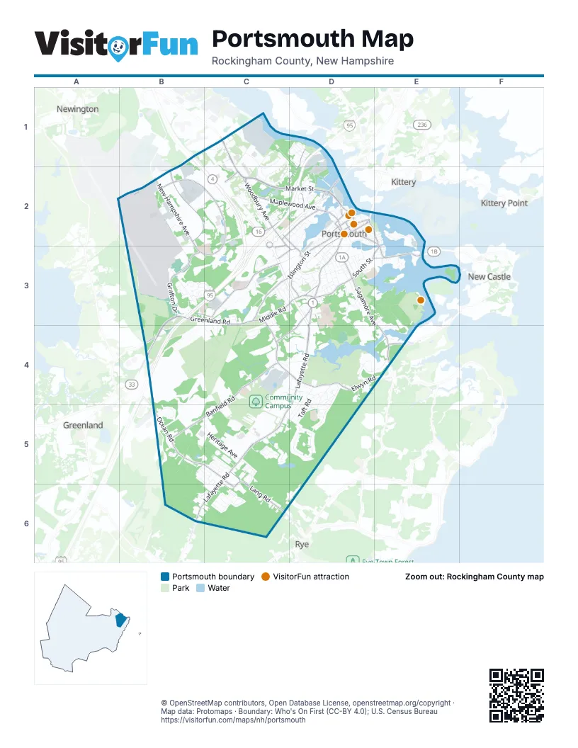
Street index of Portsmouth
Each street on the sheet and the grid squares it crosses.
- Spaulding TurnpikeB1, B2, C2, B3, C3
- Blue Star TurnpikeB3, C3, B4
- Lafayette RoadD3, D4, C5, D5, B6, C6
- State StreetD2, D3
- Middle StreetD2, D3
- Sarah Mildred Long BridgeD2
- Cutts StreetD2
- Portsmouth Traffic CircleC2, C3
- Congress StreetD2
- Daniel StreetD2
- Dutton AvenueD2
- Scott AvenueD2
- Market StreetC2, D2
- Greenland RoadB3, C3, B4
- Woodbury AvenueC1, C2, C3, D3
- South StreetE2, D3, E3
- Sagamore AvenueD3, E3, E4
- Gosling RoadB1, C1
- Middle RoadC3, D3
- New Castle AvenueD3, E3
- Pease BoulevardB1, B2
- Marcy StreetD2, E2, E3
- Pleasant StreetD2, E2
- Miller AvenueD3
- Wentworth RoadE4
- Corporate DriveB2, C2, B3, C3
- Banfield RoadC4, B5, C5
- Islington StreetD2, C3, D3
- Ocean RoadB5, C5
- Maplewood AvenueC2, D2
- Borthwick AvenueC3
- Elwyn RoadD4, E4
- International DriveB2
- Grafton DriveB3
- Peverly Hill RoadC3, C4, D4
- New Hampshire AvenueB2
- Lang RoadC5, C6
- Greenleaf AvenueD3, C4, D4
- Dennett StreetC2, D2
- Kearsarge WayD1, D2
- Bartlett StreetC2, D2, D3
- Hanover StreetD2
- Spinney RoadD3
- Longmeadow RoadC5, C6
- Rockingham AvenueC2
- Deer StreetD2
- Arthur F Brady DriveC2
- Cottage StreetC3, D3
- Fleet StreetD2
- Manchester SquareB2
- Boyd RoadC2, C3
- Bridge StreetD2
- Russell StreetD2
- Submarine WayD2
- F W Hartford DriveD5
- Heritage AvenueB5, C5
- Aviation AvenueB2, B3
- West RoadC4, D4, C5
- Sherburne RoadB3
- Suzanne DriveC5
- Colonial DriveB3, C3
- Taft RoadD4, D5
- Constitution AvenueC5
- Little Harbor RoadD3, E3
- Portsmouth BoulevardC1, C2
- Union StreetD2, D3
- Jones AvenueD3, D4
- Lincoln AvenueD3
- Odiorne Point RoadD4, E4
- McKinley RoadD4, D5
- Commerce WayC1
- White Cedar BoulevardC5
- Flightline RoadB2
- Broad StreetD3
- Coakley RoadC3
- Spring Brook CircleC5
- Buckminster WayB5
- Grant AvenueD4, D5
- Sage LaneC3, C4
- Gosport RoadD4
- Harding RoadD4, D5
- Walker Bungalow RoadD3, E3, E4
- Mariette DriveB5, C5
- Peirce Island RoadE2
- Freedom CircleC5
- Boat RoadC1, D1
- Goose Bay DriveB2, C2
- Redhook WayB1, B2
- Richards AvenueD2, D3
- Rochester AvenueB2
- Court StreetD2
- Spinnaker WayC1, C2
- Coolidge DriveD4, C5, D5
- Thornton StreetC2, D2
- Ashland RoadC2
- Belle Isle RoadE3
- Bluefish BoulevardC6
- Mirona RoadC4, D4
- Blue Heron DriveC1, C2
- Wilson RoadC4, D4
- Greenleaf Woods DriveC4, D4
- Meadow RoadC2
- Junkins AvenueD2, D3
- Eastwood DriveC6, D6
- Edmond AvenueC2
- Maritine Cottage RoadE3, E4
- Wibird StreetD3
- Leslie DriveD2
- Osprey DriveC1, C2
- Exeter StreetB2
- Aldrich RoadD3
- Regina RoadD4
- Thaxter RoadD3
- Winchester StreetC5, C6
- The Cedars of PortsmouthC5
- Clough DriveD3, E3
- Parrott AvenueD2, D3
- Durgin LaneC1, C2
- Cabot StreetD2, D3
- Durham StreetB2, B3
- Little Harbor Loop TrailE3
- Echo AvenueC2
- Essex AvenueC3
- Oak AvenueB2, C2
- Nathaniel DriveB5, C5, C6
- Rye StreetB2, C2
- Desfosses AvenueC5, C6
- Codfish Corner RoadC6
- Rockland StreetD3
- Woodlawn CircleC2
- Austin StreetD2, D3
- Cass StreetD3
- Holly LaneB3
- Hillside DriveD3
- Griffin RoadC3, C4
- Robert AvenueC5
- StonecroftC5, C6
- Highland StreetD3
- Greenside AvenueB3
- Willard AvenueD3
- Sewall RoadD3
- Melborne StreetC3
- Crescent WayD1
- Chevrolet AvenueD3
- Concord WayD1
- Cate StreetC3, D3
- Hampshire RoadC3, D3
- McDonough StreetD2
- Sheffield RoadC3, D3
- Stark StreetC2, D2
- Raleigh WayD1
- Clinton StreetD2, D3
- Coach RoadB6
- Park StreetD3
- Van Buren AvenueD4, D5
- Campus DriveC5
- Northwest StreetD2
- Farm LaneC2
- Walford LaneC4
- Barberry LaneC3
- Cleveland DriveD4, D5
- Curriers CoveD3, E3
- Country Club RoadB3
- Orchard StreetD3
- Burkitt StreetD2
- Eileen Dondero Foley AvenueC3
- Pleasant Point DriveE3
- Washington StreetD2
- Summer StreetD2, D3
- Beech StoneC5, C6
- Elwyn AvenueD3
- Bow StreetD2
- Martha TerraceB5
- Dunlin WayC1
- Juniper LaneB6, C6
- Hodgdon WayC3, D3
- Ocean Road Village CondominiumB5
- Echo HillC2
- Mechanic StreetE2
- Harrison AvenueD4, D5
- Sherburne AvenueD3
- Michael Succi DriveD2
- Taylor LaneD4
- Ranger WayD1
- Dodge AvenueC3
- Swett AvenueC3, C4
- Decatur RoadB3, C3
- Gates StreetD2, E2
- Dolphin DriveC6
- Hampton StreetB2
- Urchine AvenueC6
- Hoover DriveC5, D5
- Shearwater DriveC2
- Pheasant LaneC5
- Madison StreetD3
- Cutts AvenueD2
- Wedgewood RoadC1
- Monarch WayB6, C6
- Central AvenueD2
- Striped Bass AvenueC6
- T J Gamester AvenueD5
- Emery StreetD2
- Salmon AvenueC6
- Mackerel AvenueC6
- Porter StreetD2
- Hillcrest DriveC2
- Pinehurst RoadD3
- Laurel CourtD1
- Nixon ParkD4
- Chase DriveD2
- Oakwood DriveD4
- Denise StreetB5, C5
- Woodworth AvenueC3, C4
- Franklin DriveC2
- Edgewood RoadD4
- Simonds RoadC5
- Foundry PlaceD2
- Monroe StreetD3
- Joan AvenueC5
- Andrew Jarvis DriveD3
- Sanderling WayC2
- Sparhawk StreetD2
- Fairview DriveC2
- Weatherstone RoadB6, C6
- Hancock StreetD2, E2
- Wallis RoadC5
- Myrtle AvenueC2, D2
- Spring StreetD3
- McGee DriveC2
- Saratoga WayD1
- Brewster StreetD2
- Chapel StreetD2
- Penhallow StreetD2
- High StreetD2
- Ceres StreetD2
- Preble WayD1
- Clover LaneC2
- Pine StreetD2
- Octopus AvenueC6
- Oxford RoadC3, C4
- Albany StreetD3
- Brackett RoadD3, E3
- Atkinson StreetD2
- Sapphire StreetC2
- Fairview AvenueC2
- Boss AvenueD3
- Mill Pond WayD2
- Fells RoadD3
- Haven RoadD3
- Garfield RoadD5
- Brewery LaneD3
- Kane StreetD2
- Jackson Hill StreetD2
- Vaughan StreetD2
- Kensington RoadD3
- Pearson StreetC3
- Lawrence StreetD3
- Leavitt AvenueC3, C4
- Lee StreetB2
- Sunset RoadD3
- Diamond DriveC2
- Marjorie StreetC3, D3
- Arthur RoadD4
- Fillmore RoadD5
- Ash StreetD3
- Airline AvenueB2
- Mason AvenueB3, C3
- Shaw RoadE3, E4
- Albacore WayD1
- McClintock StreetC3, C4
- Merrimack StreetD3
- Fields RoadD3
- Church StreetD2
- Morning StreetD3
- Humphrey's CourtE3
- Porpoise WayD1
- Sims AvenueC3
- Ridges CourtE3
- Cliff RoadE3
- Sutton StreetB3
- Staysail WayC2
- Langdon StreetD2
- Marne AvenueD3
- Harvard StreetC3
- Mirona Road ExtensionC4, D4
- Brigham LaneD2
- Highliner AvenueC3
- Post RoadC5
- Sagamore GroveE4
- Holiday DriveD4
- Jefferson StreetD2
- Puddle LaneD2
- Brackett LaneD3
- Cedar Ridge CondominiumB5
- Mendum AvenueD3
- Watson's LandingD2
- Tuna TerraceC6
- Davis RoadC3, C4
- Rogers StreetD2
- Marston AvenueD3
Things to do on the Portsmouth map
Places on the map
- Atlantic Height Playground
- BJ's Wholesale Club
- Calvary Cemetery
- Cedar Healthcare Center
- Community Campus
- Corporate Center at Pease
- Creek Farm Reservation
- Drake Land
- Durgin Square
- Edgewood Center
- Extra Space Storage
- Figure Eight Beaver Pond
- General Aviation Apron
- Great Bog
- Great Bog Wildlife Management Area
- Greenleaf Woods
- Hobbs Hill
- Jones Avenue Recreation Area
- Lafayette Park
- Lafayette Plaza
- Little Harbor Trust Fund Land
- Little Harbour School
- Madison Village
- North Mill Pond
- Portsmouth Green
- Portsmouth Greenbelt
- Portsmouth High School
- Portsmouth International Airport
- Portsmouth Office Park
- Portsmouth Regional Hospital
- Sagamore Creek Headlands
- South Mill Pond
- South Street Cemetery
- Urban Forestry Center
- Water Country
- Wentworth Grove Open Space
- Wentworth-Coolidge Historic Site
Next to Portsmouth
- Greenland
- Kittery
- Kittery Point
- New Castle
- Newington
- Rye
© OpenStreetMap contributors, Open Database License, openstreetmap.org/copyright · Map data: Protomaps · Boundary: Who's On First (CC-BY 4.0); U.S. Census Bureau















