

New Jersey map
Somerset County map
About 357,467 people live here (Census Bureau, 2024 estimate). The sheet's index lists 82 streets; Amwell Road, Main Street and Middlesex Freeway cross the most grid squares. Also on it: Abandoned Quarry, ADESA New Jersey and Alexandria At Hillsborough.
Open the map (PDF, US Letter)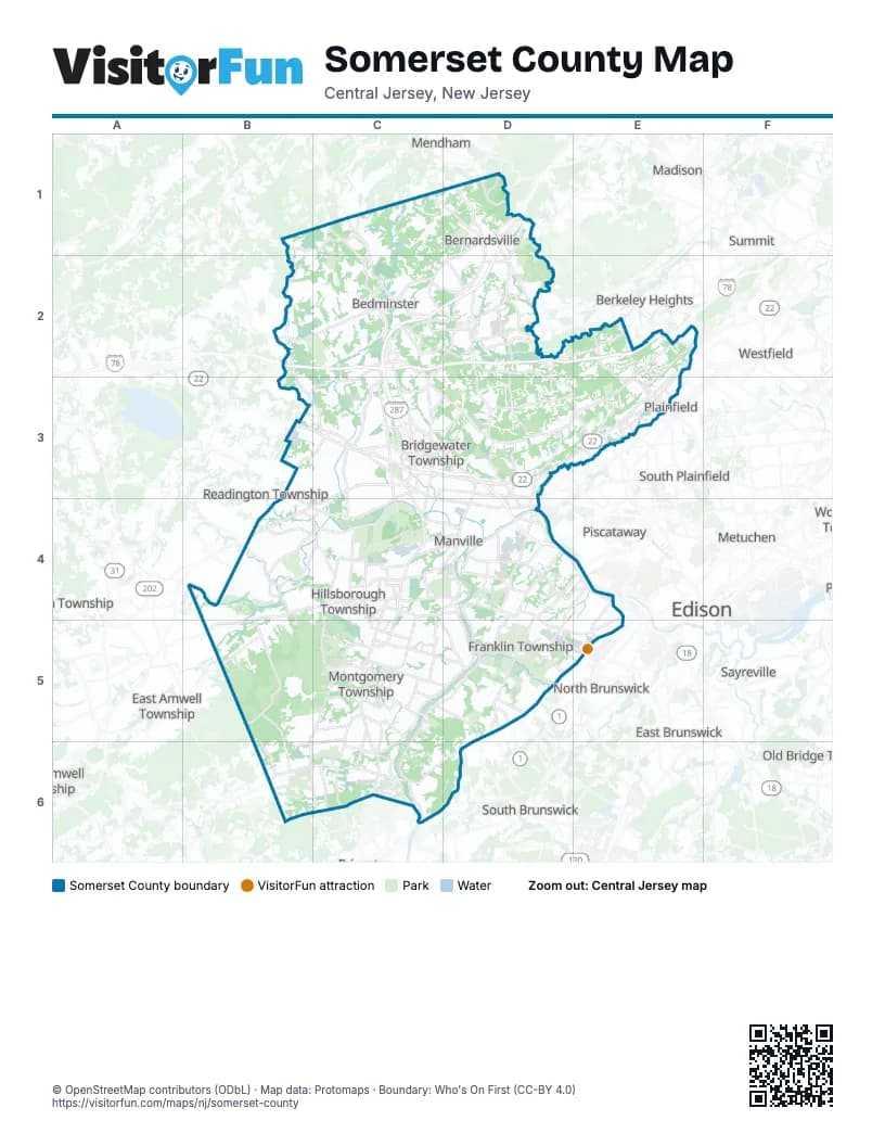
Street index of Somerset County
Each street on the sheet and the grid squares it crosses.
- Black River RoadB1
- Pottersville RoadB1, C1
- Jackson AvenueC1
- Main StreetC1, C2, D4, C6
- Mendham RoadC1, D1
- Old Chester RoadC1
- Old Chester-Gladstone RoadC1
- US Highway 206C1, C2
- Bernardsville RoadD1
- Claremont RoadD1
- Finley AvenueD1, D2
- Middlesex FreewayD1, C2, D3, D4
- Mine Brook RoadD1, C2, D2
- Morristown RoadD1
- Mount Airy RoadD1, D2
- North Finley AvenueD1, D2
- North Maple AvenueD1
- Olcott SquareD1
- Lamington RoadB2, C2
- Phillipsburg-Newark ExpresswayB2, C2, D2, E2
- Liberty Corner RoadC2, D2
- Peapack RoadC2
- Schley Mountain RoadC2
- Somerville RoadC2
- Church StreetD2
- East Oak StreetD2
- King George RoadD2, D3
- Lyons RoadD2
- Martinsville RoadD2
- Mountain AvenueD2, E2, D3, D4
- South Finley AvenueD2
- South Maple AvenueD2
- Stonehouse RoadD2
- Valley RoadD2, E2, E3
- Bonnie Burn RoadE2
- Dale RoadE2
- Drift RoadE2
- Hillcrest RoadE2
- New Providence RoadE2
- Plainfield AvenueE2
- Easton TurnpikeC3
- Garretson RoadC3
- ramp to Route 28 EastC3
- Somerville CircleC3
- US Route 22 EastboundC3
- East Union AvenueD3, D4
- Finderne AvenueD3, D4
- Mount Bethel RoadD3, E3
- Promenade BoulevardD3
- Union AvenueD3
- West Union AvenueD3
- Pearl StreetE3
- Route 22E3
- Somerset StreetE3, E5
- Warrenville RoadE3
- Washington AvenueE3
- Watchung AvenueE3
- Amwell RoadB4, C4, D4, B5, D5
- Millstone BypassC4, D4
- Peter J. Biondi Memorial BypassC4, C5
- US 206C4
- Cedar Grove LaneD4
- East Main StreetD4
- Easton AvenueD4, E4
- Millstone River RoadD4, D5
- North Main StreetD4
- Somerset Courthouse RoadD4
- South Main StreetD4
- Landing LaneE4
- River RoadC5, D5, C6
- Hamilton StreetD5, E5
- Lincoln HighwayD5, E5, C6, D6
- Franklin BoulevardE5
- French StreetE5
- How LaneE5
- Georgetown-Franklin TurnpikeB6, C6, D6
- Hopewell-Rocky Hill RoadB6
- Duffy PlaceC6
- Dunn WayC6
- Orchard RoadC6
- State RoadC6
- Washington StreetC6
Places on the map
- Abandoned Quarry
- ADESA New Jersey
- Alexandria At Hillsborough
- Amsterdam School Fields
- Ann Van Middlesworth Park
- Aster Grove
- AVE Somerset
- Barron Circle
- Basking Ridge Country Club
- Bedens Brook Farms
- Bedminster
- Bedminster Township
- Beekman Gardens
- Berkeley Circle
- Bermuda Drive
- Bernards Township
- Bernardsville
- Blawenburg
- Bloomberg Business Park
- Blue Star Shopping Center
- Bonnie Brae School
- Boudinot Southard Ross Farm
- Bound Brook
- Bound Brook Quarry
- Branchburg Commons
- Branchburg Township
- Bridgewater Commons
- Bridgewater Crossing
- Bridgewater Township
- Brookhaven Lofts
- Brookside Square
- Bunker Hill Golf Course
- Canal Walk
- Central Jersey Regional Airport
- Cherry Valley Country Club
- Claremont Hills Condominium
- Coakley-Russo Memorial Golf Course
- Colonial Park
- Colonial Park Estates
Next to Somerset County
- Berkeley Heights
- Chatham
- Cranford
- East Amwell Township
- East Brunswick
- Edison
- Flemington
- Long Hill Township
- Madison
- Mendham
- Metuchen
- New Brunswick
- North Brunswick
- Old Bridge Township
- Piscataway
- Plainfield
- Raritan Township
- Readington Township
- Sayreville
- Scotch Plains
- South Brunswick
- South Plainfield
- Summit
- Westfield
© OpenStreetMap contributors (ODbL) · Map data: Protomaps · Boundary: Who's On First (CC-BY 4.0)