

New York map
Borough Park map
A printable two-page map of Borough Park (Brooklyn, New York), drawn by VisitorFun from OpenStreetMap. Page two is the street index: every street on the sheet with its grid square, the same list as below.
Open the map (PDF, US Letter)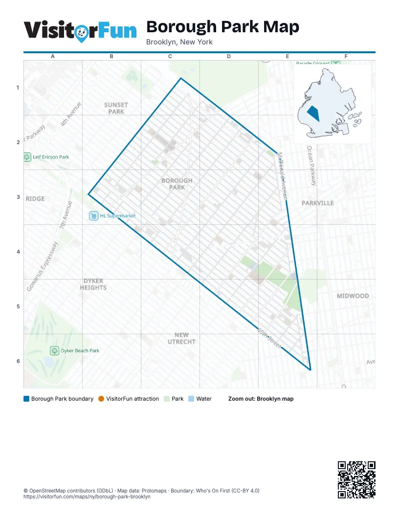
Street index of Borough Park
Each street on the sheet and the grid squares it crosses.
- 10th AvenueC1, D1, C2, B3
- 39th StreetC1, D1, D2, E2
- 40th StreetC1, D1, D2, E2, E3
- 41st StreetC1, C2, D2, E2, E3
- 9th AvenueC1, B2, C2, B3
- New Utrecht AvenueC1, C2, C3, C4
- 37th StreetD1, D2, E2
- 38th StreetD1, D2, E2
- Fort Hamilton ParkwayD1, C2, D2, B3, C3
- 51st StreetB2, C2, C3, D3, D4, E4
- 52nd StreetB2, C2, C3, D3, D4, E4
- 53rd StreetB2, C3, D3, D4, E4
- 54th StreetB2, C3, D3, D4, E4
- 55th StreetB2, C3, D3, D4, E4
- 11th AvenueC2, B3, C3
- 12th AvenueC2, D2, C3
- 42nd StreetC2, D2, E3
- 43rd StreetC2, D2, E3
- 44th StreetC2, D2, E3
- 45th StreetC2, D2, D3, E3
- 46th StreetC2, D2, E3
- 47th StreetC2, D2, E3, E4
- 48th StreetC2, D2, D3, E3, E4
- 49th StreetC2, C3, D3, E3, E4
- 50th StreetC2, C3, D3, E4
- 13th AvenueD2, C3, D3, C4
- 14th AvenueD2, C3, D3, C4
- 15th AvenueD2, E2, D3, C4, D4
- Church AvenueD2
- Old New Utrecht RoadD2, D3, E3, D4
- 16th AvenueE2, D3, E3, C4, D4
- Cortelyou RoadE2
- Dahill RoadE2, E3, E4, E5, E6
- McDonald AvenueE2, E5, E6
- 56th StreetB3, C3, D3, D4
- 57th StreetB3, C3, C4, D4, E5
- 58th StreetB3, C3, C4, D4, E5
- 59th StreetB3, C3, C4, D4, E5
- 60th StreetB3, C3, C4, D4, E5
- 61st StreetB3, C3, C4, D4, E5, E6
- 62nd StreetB3, C4, D4, D5, E5, E6
- 63rd StreetB3, C4, D4, D5, E5, E6
- 64th StreetB3, B4, C4, D4, E5, E6
- Tabor CourtC3, C4
- 17th AvenueE3, D4
- 18th AvenueE3, D4, E4, D5
- Avenue FE3
- Ditmas AvenueE3
- Webster AvenueE3
- 19th AvenueD4, E4, D5
- Dahl CourtD4
- 20th AvenueE4, D5, E5
- 21st AvenueE4, D5, E5
- Avenue IE4
- Avenue JE4
- Lawrence AvenueE4
- Parkville AvenueE4
- 23rd AvenueE5, E6
- 24th AvenueE5, E6
- Avenue ME5
- Avenue NE5
- Bay ParkwayE5
- 65th StreetE6
- Avenue OE6
- Ryder AvenueE6
Places on the map
- 100 Fun
- 10th Avenue Yard
- 13th Avenue & 39th Street
- 13th Avenue & 41st Street
- 13th Avenue & 43rd Street
- 13th Avenue & 45th Street
- 13th Avenue & 47th Street
- 13th Avenue & 49th Street
- 13th Avenue & 50th Street
- 13th Avenue & 52nd Street
- 13th Avenue & 54th Street
- 13th Avenue & 56th Street
- 14th Avenue & 39th Street
- 14th Avenue & 41st Street
- 14th Avenue & 44th Street
- 14th Avenue & 47th Street
- 14th Avenue & 50th Street
- 14th Avenue & 53rd Street
- 14th Avenue & 56th Street
- 168 Kim Wei Kitchen
- 16th Avenue Food Corner
- 18 Ave Check Cashing
- 18 Ave Home Appliance Inc
- 18th Avenue
- 18th Avenue & 45th Street
- 18th Avenue & 47th Street
- 18th Avenue & 49th Street
- 18th Avenue & 50th Street
- 18th Avenue & 53rd Street
- 18th Avenue & 55th Street
- 18th Avenue & 57th Street
- 18th Avenue & 60th Street
- 18th Avenue & 62nd Street
- 18th Avenue & 64th Street
- 18th Avenue & McDonald Avenue
- 1982 Coffee Roasters
- 20th Avenue
- 2AM Hair Salon
- 3 in 1
- 37th Street & 12th Avenue
Next to Borough Park
- Bay Ridge map
- Dyker Heights map
- Kensington map
- Midwood map
- New Utrecht
- Parkville
- Sunset Park map
© OpenStreetMap contributors (ODbL) · Map data: Protomaps · Boundary: Who's On First (CC-BY 4.0)