

New York map
Central map
A printable two-page map of Central (Buffalo, New York), drawn by VisitorFun from OpenStreetMap. Page two is the street index: every street on the sheet with its grid square, the same list as below.
Open the map (PDF, US Letter)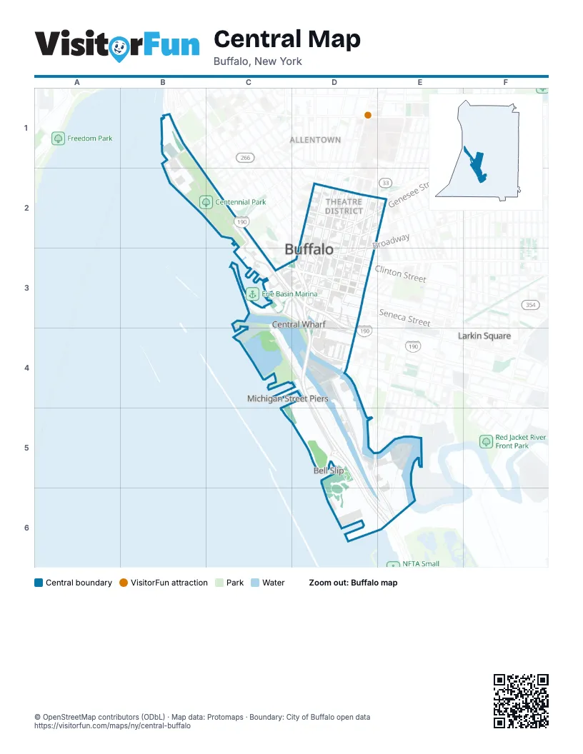
Street index of Central
Each street on the sheet and the grid squares it crosses.
- Amvets DriveB1, B2, C2
- D A R DriveB1, B2
- Niagara ThruwayB1, C2, C3, D3, D4
- Porter AvenueB1
- D. A. R. DriveB2, C2
- Lakefront BoulevardC2, C3, D3
- Bean AlleyD2
- Blossom StreetD2, D3
- Cary StreetD2
- Court StreetD2, D3
- Delaware AvenueD2, D3
- East Chippewa StreetD2
- East Huron StreetD2
- East Mohawk StreetD2
- East Tupper StreetD2
- Ellicott StreetD2, D3
- Elm StreetD2, E2, D3
- Franklin StreetD2, D3
- Genesee StreetD2, D3
- Hersee AlleyD2
- Jerge DriveD2
- Main StreetD2, D3
- Niagara SquareD2, D3
- Niagara StreetD2, D3
- North Johnson ParkD2
- Oak StreetD2, D3
- Pearl StreetD2, D3
- Saint Michaels PlaceD2
- South Elmwood AvenueD2, D3
- South Johnson ParkD2
- Sycamore StreetD2
- Tracy StreetD2
- Washington StreetD2, D3, D4
- West Chippewa StreetD2
- West Huron StreetD2
- West Mohawk StreetD2
- West Tupper StreetD2
- BinghamC3, D3
- Charles StreetC3, D3
- Church StreetC3, D3
- Erie StreetC3, D3
- Gull LandingC3
- La Riviere DriveC3
- Marine DriveC3, D3
- Ojibwa CircleC3
- Rivermist Drive NorthC3
- Rivermist Drive SouthC3
- Templeton TerraceC3
- Waterfront CircleC3
- Wilkeson WayC3
- Arsenal PlaceD3
- Booth AlleyD3
- BroadwayD3
- Buffalo SkywayD3, D4, D5, D6, E6
- Cathedral PlaceD3
- Clinton StreetD3
- Commercial StreetD3
- East Eagle StreetD3
- Exchange StreetD3
- Hanover StreetD3, D4
- Lafayette SquareD3
- Lloyd StreetD3, D4
- Lower TerraceD3
- Michigan AvenueD3, D4
- Nichols PlaceD3
- North Division StreetD3
- Perkins DriveD3
- Perry BlvdD3
- Perry BoulevardD3
- Scott StreetD3, D4
- Seneca StreetD3
- Seymore H. Knox III PlazaD3, D4
- South Division StreetD3
- Swan StreetD3
- Upper TerraceD3
- West Eagle StreetD3
- West Seneca StreetD3
- West Swan StreetD3
- William StreetD3
- Fuhrmann BoulevardC4, D4, D5, D6, E6
- Baltimore StreetD4
- Columbia StreetD4
- Ganson StreetD4, D5
- Illinois StreetD4
- Mississippi StreetD4
- Ohio StreetD4, D5, E5, E6
- Outer Harbor DriveD4, D5
- Perry StreetD4
- Prime StreetD4
- Shoreline TrailD4
- South Michigan AvenueD4
- South Michigan Avenue Lift BridgeD4
- South Park AvenueD4
- Silo City RowD5, E5
- Fuhrmann BoulevatdE6
Places on the map
- 157 Exchange Street Lot
- 201 Ellicott Apartments
- 500 Pearl
- Adam Ramp
- Agway Elevator
- Alumni Plaza
- American/Peavey
- American/Peavey Elevator
- Augspurger Ramp
- Buffalo and Erie County Naval & Military Park
- Buffalo and Erie County Naval & Military Park Museum
- Buffalo Animal Shelter
- Buffalo Central Library
- Buffalo City Court
- Buffalo City Hall
- Buffalo Fire Department E-1 L-2
- Buffalo Grand Hotel & Event Center
- Buffalo Iron Works
- Buffalo Marriott at LECOM Harborcenter
- Buffalo Niagara Convention Center
- Buffalo Place
- Buffalo Platform
- Buffalo Police Department B District
- Buffalo RiverWorks
- Buffalo RiverWorks Parking Lot
- Buffalo Skate Plaza
- Buffalo–Exchange Street Station
- Bully Hill Party Deck
- Buoy Yard
- Burt Flickinger Athletic Center
- Captain of the Port
- Cars Sharing Main Street Mohawk to Exchange Street Section
- Cazenovia Community Boating Center
- Centennial Park
- Centennial Pool
- CGX
- Charles & Marie Fontana Boathouse
- City of Buffalo Police Substation at Canalside
- City Ship Canal
- Colonel Ward Pumping Station
Next to Central
- Allentown map
- Bell Slip
- Fruit Belt map
- Larkin Square
- Larkinville
- Lower West Side map
- Michigan Street Piers
© OpenStreetMap contributors (ODbL) · Map data: Protomaps · Boundary: City of Buffalo open data