

New York map
Central Park map
A printable two-page map of Central Park (Buffalo, New York), drawn by VisitorFun from OpenStreetMap. Page two is the street index: every street on the sheet with its grid square, the same list as below.
Open the map (PDF, US Letter)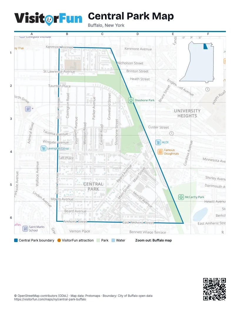
Street index of Central Park
Each street on the sheet and the grid squares it crosses.
- Alden AvenueB1
- Hecla StreetB1, B2
- Starin AvenueB1, B2, B6
- Kenmore AvenueC1
- Klauder RoadC1
- Nicholson StreetC1
- North Parker AvenueC1, C2
- Parker BoulevardC1
- Rosemary AvenueC1, C2
- Seattle StreetC1
- Covington RoadB2, B3
- Rachel Vincent WayB2
- St Lawrence AvenueB2, C2
- Taunton PlaceB2, C2
- Voorhees AvenueB2, B3, B4, B6
- Brinton StreetC2
- Carmel RoadC2, C4
- Groveland StreetC2, C3
- Parker AvenueC2, C4, C6
- Shoshone StreetC2, C3, C4
- Winston RoadC2, B3, C3, B4
- Heath StreetD2
- Admiral RoadB3
- North DriveB3
- Parkside AvenueB3, C3, D3
- Tacoma AvenueB3, C3
- Parkside CourtC3, D3
- Hertel AvenueB4, C4, D4
- Huntington AvenueB4, C4, D4, D5
- Sagamore TerraceB4, B5
- Taft PlaceB4
- Wingate AvenueB4
- Wesley AvenueC4, C5
- Beard AvenueD4, C5, D5, B6, C6
- William Price ParkwayE4, E5
- Woodbridge AvenueB5, C5, D5
- Benwood AvenueC5, D6
- Depew AvenueC5, D5
- Main StreetC5, D5, C6
- Morris AvenueC5, C6
- East Depew AvenueD5, D6
- Mercer AvenueD5, D6, E6
- Hill StreetE5, D6
- Manhattan AvenueE5, E6
- Duane TerraceB6
- Linden AvenueB6
- Amherst StreetC6
- East Amherst StreetC6
- East Morris AvenueC6, D6, E6
- Pannell StreetC6
- Holden StreetD6
Places on the map
- Buffalo Fire Station Engine 34 / Ladder 7 Quarters
- Carmelite Monastery
- Central Park United Methodist Church
- Community Health Center of Buffalo
- Dash's Market
- Dr Bob's Dental Care
- Elbers Landscape Service
- Gospel Temple Church of God
- Hair Que
- Heritage Locksmith
- Illos Piano Restoration
- Park and Ride Lot
- People Inc
- Planned Parenthood
- Ripen With Us
- Robert Rich Senior All High Stadium
- Saint Clare Apartments
- Saint Rose Of Lima Catholic Church
- Shoshone Park
- Zone One Family Entertainment Complex
Next to Central Park
© OpenStreetMap contributors (ODbL) · Map data: Protomaps · Boundary: City of Buffalo open data