

New York map
Dix map
About 3,538 people live here (Census Bureau, 2024 estimate). The sheet's index lists 133 streets; State Highway 414, County Route 19 and Meads Hill Road cross the most grid squares. Things to do inside the boundary: Watkins Glen State Park.
Open the map (PDF, US Letter)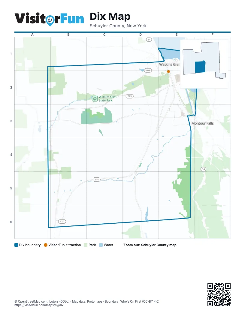
Maps inside Dix
1 map inside, from the street map of Dix down.
Street index of Dix
Each street on the sheet and the grid squares it crosses.
- County Line RoadB1, C1, D1
- Cross RoadB1, B2
- Ellison RoadC1, C2
- Teddy Bear LaneC1
- Tennesee Bunker DriveC1
- Vanzandt Hollow RoadC1, B2, B3
- Division StreetD1, E1
- Lakeview AvenueD1, E1
- Orchard AvenueD1
- State Route 409D1, D2
- West Second StreetD1, E1
- Boat Launch RoadE1
- Cedar StreetE1
- Cemetery RoadE1, D2, E2
- East Eighth StreetE1
- East Fourth StreetE1
- East Second StreetE1
- Fifth StreetE1
- First StreetE1
- Jackson StreetE1
- Lake Shore DriveE1
- Magee StreetE1, E2
- Ninth StreetE1, E2
- North Decatur StreetE1, E2
- North Franklin StreetE1, E2
- North Monroe StreetE1
- North Perry StreetE1, E2
- North Porter StreetE1, E2
- Pine StreetE1, E2
- Rock Cabin RoadE1, F1, F2
- Seventh StreetE1
- Sixth StreetE1
- South Glen AvenueE1
- South Jackson StreetE1
- South Madison AvenueE1
- South Monroe StreetE1
- Steuben StreetE1, E3
- Tenth StreetE1, E2
- Third StreetE1
- West Eighth StreetE1
- West Fourth StreetE1
- West Fouth StreetE1
- Templar RoadA2, B2
- Happy TrailC2
- Meads Hill RoadC2, C3, C4, C5, D5
- Punch Bowl RoadC2, D2
- State Highway 329C2, D2, E2
- Station RoadC2, D2
- Townsend RoadC2, B3, C3
- Whites Hollow RoadC2
- Willow DriveD2, E2
- Clarence StreetE2
- County Road 17E2, D3, E3
- County Road 31E2, E3
- Durland PlaceE2
- Eleventh StreetE2
- Fairgrounds LaneE2
- Fifteenth StreetE2
- Fourteenth StreetE2
- Grandview AvenueE2
- Marina DriveE2, E3, F3
- Marina RoadE2
- Old Corning RoadE2
- Porter StreetE2
- Santley LaneE2
- Shannon StreetE2
- South AvenueE2
- South Decatur StreetE2
- South Franklin StreetE2, E3
- South Perry StreetE2
- State Highway 414E2, D3, E3, D4, B5, C5, D5, B6
- State Route 419E2
- Twelfth StreetE2
- Walnut RoadE2
- County Route 16A3, B3, C3, D3, E3
- County Route 19A3, B3, A4, B4, B5, B6
- Baker Hill RoadB3, B4, B5
- Old Joe RoadB3
- Barry LaneC3
- Pit LaneC3, C4
- The EssesC3, C4
- The NinetyC3
- Watkins Glen InternationalC3, C4
- Wedgewood RoadC3, D3
- Belle P Cornell DriveE3
- Coykendall RoadE3, D4, E4
- Cronk RoadE3, D4, E4
- North Catherine StreetE3
- Wgmf RoadE3
- Wollet RoadA4
- Hedden RoadB4, C4
- Bronson Hill RoadC4, C5
- Inner LoopC4
- Outer LoopC4
- Short CourseC4
- The BootC4
- The ChuteC4
- The Fast LefthanderC4
- The HeelC4
- The ToeC4
- Bennett RoadD4
- County Route 18D4, D5, D6
- Allen RoadE4
- Froggy LaneE4
- Gano RoadE4, E5
- Oakley LaneE4
- Price RoadE4, D5, E5
- Anthony RoadA5, B5
- Swarthout LaneA5, B5
- Beaver Dams Moreland RoadB5, C5, D5, E5, B6
- Cooley RoadB5
- Rockwell RoadB5
- Walt Gilbert RoadB5, C5
- Catlin Hill RoadC5, D5, C6
- De MunnC5
- De Munn RoadC5, C6
- Koa DriveC5
- Mill Hill RoadC5, D5
- Parrish RoadC5
- Pearl StreetC5
- Russell Hill RoadC5
- Yskamp PlaceC5
- Dug RoadD5, E5
- King Hill RoadE5, E6
- Lawrence Johnson RoadE5
- Roloson Hollow RoadE5, E6
- Hornby RoadA6, B6
- County Route 20B6
- Duvall RoadB6
- Hall RoadB6
- New RoadE6
- Roloson Hill RoadE6
- Wren HollowE6
Things to do on the Dix map
Places on the map
- Advance Auto Parts
- Arby's
- Bad Indian Swamp
- Baker Hill
- Beaver Dams Cemetery
- Beaver Dams Post Office
- Classy Chassy Car Wash
- Clute Park
- CVS Pharmacy
- El Rancho Mexican Restaurant
- First Baptist Church
- First Methodist Church
- First Presbyterian Church
- Glenwood Cemetery
- Harbor Park
- Hemlock Run Airport
- Hidden Valley Camp Road
- Kingdom Hall of Jehovah’s Witnesses
- KOA Kampground
- LaFayette Park
- Lily Pond
- Marina Park
- Royce-Chedzoy Funeral Home
- Saint James Episcopal Church
- Saint Mary of the Lake Roman Catholic Church
- Saint Marys Cemetery
- Schuyler County Court House
- Schuyler Hospital
- Six Nations Campground
- The Glen Theater
- Tobey's Donut Shop
- Tops
- Town of Dix
- Visions Federal Credit Union
- Walmart Supercenter
- Watkins Glen
- Watkins Glen Elementary School
- Watkins Glen High School
- Watkins Glen International
- Watkins Glen Municipal Hall
Next to Dix
- Montour Falls
© OpenStreetMap contributors (ODbL) · Map data: Protomaps · Boundary: Who's On First (CC-BY 4.0)