

New York map
Watkins Glen map
About 1,746 people live here (Census Bureau, 2024 estimate). The sheet's index lists 78 streets; Rock Cabin Road, North Glen Avenue and East Fourth Street cross the most grid squares. Things to do inside the boundary: Watkins Glen State Park.
Open the map (PDF, US Letter)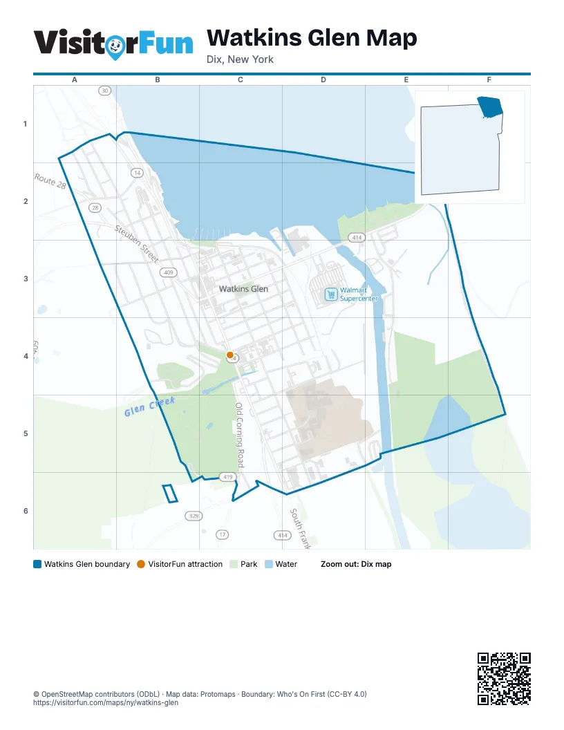
Street index of Watkins Glen
Each street on the sheet and the grid squares it crosses.
- Howard AvenueA1, A2
- Middlesex RoadA1
- North Glen AvenueA1, A2, B2, B3
- Reading RoadA1, B1
- Summit AvenueA1, A2
- County Road 30B1
- Kimberly LaneB1
- Salt Point RoadB1, B2
- Bath StreetA2, B2
- County Line RoadA2
- County Route 28A2
- Lee StreetA2
- Little StreetA2
- Scenic PlaceA2, B2
- Steuben StreetA2, B2, B3
- Cross StreetB2, B3
- Magee Point RoadB2
- Margaret LaneB2, B3
- North Jackson StreetB2, B3
- North Madison AvenueB2, B3
- North Monroe StreetB2, B3
- Partition StreetB2
- Seneca StreetB2
- East Fourth StreetD2, E2, C3, D3
- Boat Launch RoadE2, E3, E4
- Rock Cabin RoadE2, F2, F3, F4, F5
- Division StreetA3, B3
- Orchard AvenueA3, B3
- First StreetB3, C3
- Jackson StreetB3
- Lake Shore DriveB3
- Lakeview AvenueB3, B4
- North Franklin StreetB3, C3, C4
- South Glen AvenueB3, B4
- South Jackson StreetB3, B4
- South Madison AvenueB3, C3, C4
- South Monroe StreetB3, C4
- West Fourth StreetB3, C3
- West Second StreetB3, C3
- East Second StreetC3
- Fifth StreetC3, D3
- Magee StreetC3, D3, D4
- North Decatur StreetC3, C4
- North Perry StreetC3, D3, D4
- North Porter StreetC3, D4
- Seventh StreetC3, D3, C4
- Sixth StreetC3, D3, C4
- Third StreetC3
- West Fouth StreetC3
- East Eighth StreetD3, C4
- Cedar StreetB4
- Cemetery RoadB4, C4
- Pine StreetB4, C4
- Clarence StreetC4, D4
- Eleventh StreetC4
- Ninth StreetC4, D4
- Old Corning RoadC4, C5, C6
- Santley LaneC4, C5
- South Decatur StreetC4, C5, D5, D6
- South Franklin StreetC4, C5, D6
- Tenth StreetC4, D4
- Twelfth StreetC4, D4, C5
- West Eighth StreetC4
- Porter StreetD4
- Shannon StreetD4
- South Perry StreetD4
- Durland PlaceC5
- Fifteenth StreetC5, D5
- Fourteenth StreetC5, D5
- Grandview AvenueC5, D5
- South AvenueC5, D5
- Fairgrounds LaneD5, E5, D6
- Marina RoadE5
- State Route 419B6, C6
- County Road 17C6
- State Highway 329C6
- Walnut RoadC6
- Willow DriveC6
Things to do on the Watkins Glen map
Places on the map
- Advance Auto Parts
- Arby's
- Classy Chassy Car Wash
- Clute Park
- CVS Pharmacy
- El Rancho Mexican Restaurant
- First Baptist Church
- First Methodist Church
- First Presbyterian Church
- Glenwood Cemetery
- Harbor Park
- LaFayette Park
- Lily Pond
- Royce-Chedzoy Funeral Home
- Saint James Episcopal Church
- Saint Mary of the Lake Roman Catholic Church
- Schuyler County Court House
- The Glen Theater
- Tobey's Donut Shop
- Tops
- Visions Federal Credit Union
- Walmart Supercenter
- Watkins Glen
- Watkins Glen Elementary School
- Watkins Glen High School
- Watkins Glen Municipal Hall
- Watkins Glen Public Library
- Watkins Glen School Apartments
- Watkins Glen State Park Gift Shop
- Watkins Glen Villager Motel
- Watkins Motel
- Wright's Beverages
© OpenStreetMap contributors (ODbL) · Map data: Protomaps · Boundary: Who's On First (CC-BY 4.0)