

New York map
Lake Placid map
About 2,302 people live here (Census Bureau, 2024 estimate). The sheet's index lists 91 streets; Mill Pond Drive, Mirror Lake Drive and Saranac Avenue cross the most grid squares. Also on it: Adirondack Community Church, Adirondack Corner Store & Deli and Alpine Mall.
Open the map (PDF, US Letter)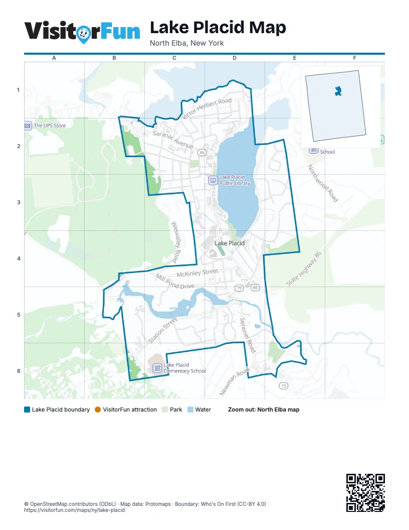
Street index of Lake Placid
Each street on the sheet and the grid squares it crosses.
- Peninsula RoadB1
- Saranac AvenueB1, B2, C2, D2
- State Highway 86B1
- Onondaga TrailC1, C2
- Opeechee WayC1
- Seneca TrailC1, D1
- Victor Herbert RoadC1, D1, C2
- George and Bliss LaneD1
- Harbor LaneD1
- Interlaken AvenueD1, D2
- Mirror Lake DriveD1, D2, E2, D3, D4
- Signal Hill RoadD1, D2
- Stevens RoadD1, C2, D2
- Walsh RoadD1
- Yacht Club WayD1
- Acorn StreetB2, C2
- Chickadee LaneB2
- Greenwood StreetB2, C2
- Wesvalley RoadB2, C2, C3, C4
- Cayuga WayC2
- Cherokee TrailC2
- Elm StreetC2, C3
- Essex StreetC2, C3
- Grandview AvenueC2, C3
- Hayes StreetC2, D3
- Hillcrest AvenueC2, C3
- Maple StreetC2
- Margaret PlaceC2, D2
- Nash StreetC2
- Pioneer LaneC2
- Sheldrake WayC2
- Waters Edge WayC2
- Main StreetD2, D3, D4
- Norton RoadD2
- Swiss RoadD2
- Beech Hill CircleE2
- Wilderness CircleE2
- Highland PlaceC3
- Kate Smith AvenueC3
- Marcy RoadC3, D3
- Olympic DriveC3, D3
- Oneida AvenueC3
- Cedars WayD3, E3
- Garden WayD3, E3
- Lake Placid Club WayD3, E3, D4, E4
- Parkside DriveD3, D4
- Dewey Decimal WayE3
- Norsnol WayE3
- Mill Pond DriveB4, C4, D4, B5, C5, D5
- Cummings RoadC4, D4
- McKinley StreetC4, D4
- School StreetC4, D4
- Smith LaneC4
- The Commons WayC4, C5
- Colden AvenueD4, D5
- Dunn WayD4
- McCasland WayD4
- McLenathen AvenueD4
- Middle StreetD4
- Morningside DriveD4
- Roy WayD4
- Searle LaneD4
- South Main StreetD4, D5
- Spring StreetD4
- Wilmington RoadD4, D5
- Karibu WayE4
- Chabbott WayB5, B6
- Cimerron TrailB5, C5
- June WayB5, B6
- Long Pond TrailB5, C5, C6
- Old Military RoadB5, B6
- Blueberry Ridge RoadC5
- Hough WayC5, C6
- Oak WayC5, D5
- Otter WayC5
- Station StreetC5, D5, B6
- Trillium DriveC5, D5, C6
- Chub River WayD5
- Dooling WayD5
- Dow RoadD5
- Fir WayD5
- Hurley AvenueD5
- McIntyre WayD5
- Power House LaneD5, E5, E6
- Sentinel RoadD5, D6
- Alpine LaneE5
- Averyville LaneB6
- Cascade RoadD6
- New StreetD6
- Newman RoadD6
- Nichols StreetD6
Places on the map
- Adirondack Community Church
- Adirondack Corner Store & Deli
- Alpine Mall
- American Legion Hall - Post 326
- Best Western Adirondack Inn
- Big Z’s Hangout at Lake Placid Lanes
- Courtyard Lake Placid
- Cunningham's Ski Barn
- Dunn Way
- Faizy’s Fun House
- Fratellis
- Golden Arrow Lakeside Resort
- Hampton Inn & Suites Lake Placid
- Herb Brooks Arena
- Jack Shea Arena
- James B. Sheffield Olympic Skating Rink
- L. Post Rustics Artisan Furniture & Fine Art
- Lake House
- Lake Placid Baptist Church
- Lake Placid Club Grandview Hotel
- Lake Placid Elementary School
- Lake Placid Family Dental
- Lake Placid Flower & Gift
- Lake Placid High School
- Lake Placid Inn Boutique Hotel
- Lake Placid Pub & Brewery
- Lake Placid Public Beach
- Lake Placid Public Library
- Lake Placid Synagogue
- Lake Water Pool
- Lisa G's
- Locker Room 5
- Man and Beast
- Mirror Lake
- North Elba Town Hall
- Olympic Center
- Origin Coffee Co. (Lake Placid, NY)
- Palace Theatre
- Placid Bay Hotel
- Placid Boatworks
© OpenStreetMap contributors (ODbL) · Map data: Protomaps · Boundary: Who's On First (CC-BY 4.0)