

New York map
Poughkeepsie map
About 32,293 people live here (Census Bureau, 2024 estimate). The sheet's index lists 300 streets; Sheafe Road, River Edge Drive and Summersweet Drive cross the most grid squares. Things to do inside the boundary: Frances Lehman Loeb Art Center, Poughkeepsie Galleria and Vassar Modfest.
Open the map (PDF, US Letter)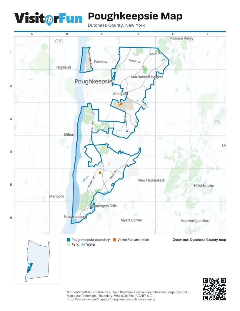
Street index of Poughkeepsie
Each street on the sheet and the grid squares it crosses.
- South RoadC3, C4, C5
- Dutchess TurnpikeD1, E1, D2
- Manchester RoadD2, D3
- North RoadC1
- Delafield StreetC1, C2
- Haight AvenueD2
- Marist DriveC1
- East-West ArterialD2
- Albany Post RoadC5
- Salt Point TurnpikeC1, D1, C2
- New Hackensack RoadD3
- Raymond AvenueC2, C3, D3
- Innis AvenueC2
- Spackenkill RoadC3, C4, D4
- West Main StreetC5
- Sheafe RoadC4, C5, B6, C6
- Van Wagner RoadD1, D2
- Vassar RoadD4, C5
- Channingville RoadC5, B6, C6
- Wilbur BoulevardC3
- Hooker AvenueC3, D3
- Cedar AvenueC3
- Spring RoadC5
- Delavergne AvenueC5
- Tucker DriveD2
- Main StreetD2, B6
- Jackson RoadC5, D5
- De Garmo RoadD2
- New Hamburg RoadB6
- IBM RoadC4
- Old Post RoadC5
- Burnett BoulevardD2
- Sand Dock RoadB4, C4
- Creek RoadC1, C2
- Old Manchester RoadD3
- Taft AvenueD2
- Cherry Hill DriveD2
- River Edge DriveB3, C3, B4, C4
- North Grand AvenueD1, C2, D2
- Boardman RoadD3, D4
- Rochdale RoadE1, E2
- Overocker RoadD2
- Bedell RoadD1
- Hillis TerraceC4, D4
- Wildwood DriveC4
- Thomas Watson DriveC3, C4
- Underhill RoadC1, D1, D2
- Thelberg RoadD2, D3
- Bower RoadD1, E1
- Ireland DriveD2
- Sutton Park RoadD4
- Stratford DriveE1
- Page Park DriveD2, D3
- Tamarack Hill DriveD1, E1
- Alexander BoulevardC4, D4
- Hornbeck RoadD1, D2
- Vero DriveD1
- Mapleknoll RoadB5, C5
- Kensington LaneE1
- Edgewood DriveD1
- Ridgeview RoadD3
- Autumn DriveD4
- Brooklands Farm RoadC4
- Cottam Hill RoadC5
- Regency DriveD1, D2
- Rivercrest CourtB3, C3
- Skyview DriveD2, E2
- Clearwater DriveC1
- Ray BoulevardC2, D2
- Crestwood BoulevardC2
- TrailerD2
- Lincoln DriveC5
- Edvard Bech DriveC1
- Kerr RoadC4, C5
- Victor LaneC4, C5
- Carriage Hill LaneD3
- Enterprise DrC4
- Henmond BoulevardD3
- Homer PlaceD3
- Sandi DriveC5
- George T Bowdoin WayB5, C5, B6
- Merrywood RoadC5
- Coachlight DriveD3
- Hart DriveE1
- Camelot RoadC4
- Sunrise LaneD3
- Lorraine BoulevardD4, C5, D5
- Overlook DriveD2
- Wendy DriveC5
- Ridge RoadD2
- Champagnat WayC1
- Sharon DriveC3
- Shamrock CircleD2
- Marple RoadC2, D2
- Stephanie LaneC5
- Castle BoulevardC4, C5
- Hudson Harbor DriveC3
- Waterworks RoadC1
- Old Field RoadD2
- Development CrB3, C3
- Cathy RoadC3
- Colette DriveC4
- Tanglewood DriveC5
- Evergreen AvenueC3
- Monroe DriveC5
- Gables BoulevardD1
- Deer Run RoadC4, D4
- Brewers LaneC3
- Hornbeck RidgeD3
- Swenson DriveC5
- Strawberry Hill RoadC5
- Dragotta RoadC4, C5
- Woodland DriveC5
- John Winslow DriveC1
- Beechwood AvenueC3
- Spy HillD3
- Peach RoadD1
- Earlwood DriveD3
- Greenvale Farms RoadD3
- Briarcliff AvenueC4, C5
- Field CourtC3
- Victory LaneD2
- Jackman DriveC2
- Knollwood LaneE1
- Old English WayC5
- Mountainview RoadD2
- Cliff House LaneB4
- Susie BoulevardD2
- Trailer ParkC5
- Friendly LaneD2
- Townsend BoulevardD1, D2
- Delbaso BoulevardB6, C6
- Catskill AvenueD2
- Thelburg RoadD2
- Valley View RoadC3
- Lori StreetC4, C5
- Thomas AvenueD2
- Edwin RoadD2
- Johns BoulevardC2, D2
- Main CircleD3
- Claudia LaneD4
- Bridge StreetB6
- Phyllis RoadC6
- Lindbergh PlaceC2
- Vassar Lake DriveC3, D3
- Jordan StreetC6
- Beechwood ParkC3
- Zach's WayD3
- McIntosh DriveD3
- Durocher TerraceD2
- Hudson AvenueC2
- Jonathan LaneC3
- Shore Line RoadB4
- Hampton RoadD4
- Jackson Drive NorthC5, D5
- Janet DriveD2
- Manchester CircleD2
- Old Silvermine PlaceD3
- Edge Hill RoadC5
- Ziegler AvenueC2, C3
- Cedar Valley RoadD3
- Maple Syrup DriveB5
- Fallkill AvenueC2
- Rowley RoadC5
- Trotter LaneD3
- Degarmo RoadD2
- Cooper RoadD2
- Rochambeau LaneC4
- Spring Manor CircleC3
- Honey LaneB6
- Misty Ridge CircleD4
- Brian RoadC5
- Point StreetB6
- Dublin LaneD2
- Caroline AvenueD1, D2
- Hillside DriveD2
- Sterling PlaceC5
- Oakwood DriveC5
- Meadow DriveC5
- Parkside DriveD2
- Reed AvenueB6
- Sheate Manor RoadC5
- Wasson DriveC5
- Sherwood DriveC5
- Titus RoadE2
- Patricia RoadD1
- Sunstone DriveC1, D1
- James StreetD2
- Peckham RoadD2
- Scofield HeightsC4, D4
- Longview RoadD2
- Argent DriveC5
- Clover WayC3
- Vassar View RoadD2
- Lafko DriveD2
- Corlies AvenueC2
- Innovation WayC3
- Morehouse RoadC3
- Naples DriveD1
- Mary AvenueE1
- Caywood RoadC2
- Lawton RoadC5
- Evelyn WayD2
- Bennett RoadC1
- Darrow PlaceD2
- Walnut Hill RoadC3
- Short Hill DriveD2
- Roland TerraceD4
- Watson DriveC3
- Wayne DriveC4
- Wendover DriveC5
- Love RoadD2
- North DriveD2, D3
- Toddy LaneD4
- Biscayne BoulevardD1
- Pehl RoadC2
- Town Center DriveD2
- Summersweet DriveC1, D1, C2, D2
- White Marina at Point StreetB6
- Susan LaneC5
- Tower LnB4, C4
- Harmony CircleE2
- Twin RoadB6
- Wiltse LaneD2
- Ridgewood TerraceC4
- Dartmouth DriveE1
- Macdonnell HeightsD2
- Cleveland DriveC5
- Eileen BoulevardD2
- Sugar Maple RoadD4
- Eastern ParkwayD2
- Husky Hill RoadC4
- Jackson Drive SouthD5
- Willowbrook HeightsD4
- Golf Club LaneC4
- McKinley LaneC2
- Fitchett WayC1, C2
- Shady Tree LaneE1
- Thames RoadE1
- Greystone LaneC3
- Founders WayD2
- Williams RoadD2
- Glen DriveC5
- Cedar Pond LaneC3
- West Bank RoadE2
- East Bank RoadE2
- Stone StreetB6
- Pewter CourtC5
- Ansara RoadC5
- Barnegat RoadC4
- Brett PlaceD2
- Ann StreetE1
- Dutchess Landing RoadB2, C2
- Ronnie LaneC4
- Silver LaneD4
- Vaeth RoadD4
- Vista LaneD1
- Peekaboo LaneC5
- Lawson StreetB6
- Harvard DriveD1
- Van Siclen DriveC3
- Hawthorne LaneD4
- Fiji LaneD1
- Pleasant View RoadE1
- Assembly AvenueB4, C4
- Gentry BendD3
- Priscilla LaneC3
- Toomey DriveD3
- Orlando DriveD1
- Barnes DriveD2
- Eagle View LaneB5
- Smokerise LaneC5
- Camelford DriveC4
- Dorland AvenueD2
- Logans CourtD4
- Casper's Kill DriveD3
- North Jackson RoadC5
- Broadview RoadC5
- Meadow RoadD2
- Clubhouse DriveD1
- Stanley StreetE1
- Surrey LaneD3
- Lenape CircleC5, C6
- Haines RoadD2
- Pearl Bush LaneD4
- Locust RoadD2
- Otto WayD2
- Hickory LaneB6, C6
- River RoadB6
- Wing RoadD2
- Santa Anna DriveC3
- Gertrude PlaceC5
- Jay RoadD4
- Malmros TerraceC5
- Stanton TerraceD1, D2
- Whipple WayD1, D2
- Bermuda BoulevardD1
- Kimlin CourtC3
- North Gate RoadC1
- Oak Bend RoadD4
Things to do on the Poughkeepsie map
Places on the map
- Bilmar Nurseries Inc
- Bowdoin Park
- Casperkill Golf Club
- Coablt Lake
- Dutchess Golf Club
- Fern Tor
- Gartland Athletic Field
- Greenvale Park
- Hillis Park
- Hudson Plaza
- IBM
- Locust Grove
- Lowe's
- MacDonnell Heights
- Mailroom
- Marist College
- Marist University
- McCann Baseball Field
- McCann Golf Course
- New Hamburg
- New Hamburg Yacht Club
- Oak Grove Elementary School
- Oakwood Commons
- Peach Hill
- Peach Hill Park
- Post Road Plaza
- Poughkeepsie Galleria
- Poughkeepsie Rural Cemetery
- Poughkeepsie Speedway
- Quiet Cove Riverfront Park
- Saint Peter's Cemetery
- Solvang Tree Farm
- South Road Crossing
- South Road Post Office
- Spratt Park
- Sunfish Cove
- The Shoppes at South Hills
- Vassar College
- Vassar Golf Course
- Vassar's Back Yard
Next to Poughkeepsie
- Arlington
- Fairview
- Highland
- Hillside Lake
- Hopewell Junction
- Marlboro
- Milton
- Myers Corner
- New Hackensack
- Pleasant Valley
- Wappingers Falls
© OpenStreetMap contributors, Open Database License, openstreetmap.org/copyright · Map data: Protomaps · Boundary: Who's On First (CC-BY 4.0)















