

Oregon map
Portland map
About 635,749 people live here (Census Bureau, 2024 estimate). The sheet's index lists 251 streets; Southeast Powell Boulevard, Northeast Marine Drive and Northeast Airport Way cross the most grid squares. Things to do inside the boundary: A Convenient Cycle, Arlene Schnitzer Concert Hall and Around Portland Tours.
Open the map (PDF, US Letter)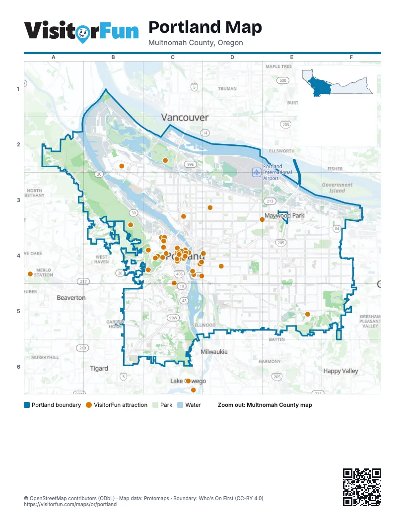
Street index of Portland
Each street on the sheet and the grid squares it crosses.
- North Columbia BoulevardB1, B2, C2, C3
- North Marine DriveB1, B2, C2
- Northwest Germantown RoadA2, B2, A3, B3
- Northwest Newberry RoadA2
- Northwest Saint Helens RoadA2, B2, B3, C4
- Northwest Skyline BoulevardA2, A3, B3, B4
- North Columbia WayB2
- North Fessenden StreetB2
- North Ivanhoe StreetB2
- North Lombard StreetB2, B3, C3
- North Philadelphia AvenueB2
- North Portland RoadB2, C2
- North Richmond AvenueB2, B3
- North Saint Louis AvenueB2
- Northwest Bridge AvenueB2, B3
- Saint Johns BridgeB2, B3
- Interstate BridgeC2
- North Denver AvenueC2, C3
- North Marine WayC2
- North Martin Luther King Junior BoulevardC2
- North Tomahawk Island DriveC2
- North Union CourtC2
- North Vancouver WayC2
- Northeast Marine DriveC2, D2, E2, E3, F3
- Northeast Martin Luther King Junior BoulevardC2, C3, C4
- ArrivalsD2
- DeparturesD2
- Northeast 33rd DriveD2, D3
- Northeast Airport WayD2, E2, D3, E3, F3
- Glenn L. Jackson Memorial BridgeE2, E3
- North Willamette BoulevardB3, C3
- Northwest Front AvenueB3, C3, C4
- Northwest Kittridge AvenueB3
- Northwest Yeon AvenueB3, C3, C4
- North Anchor StreetC3
- North Argyle StreetC3
- North Argyle WayC3
- North Basin AvenueC3
- North Channel AvenueC3
- North Cook StreetC3
- North Fremont StreetC3
- North Going StreetC3
- North Greeley AvenueC3
- North Interstate AvenueC3, C4
- North Killingsworth StreetC3
- North Minnesota AvenueC3
- North Missouri AvenueC3
- North Rosa Parks WayC3
- North Vancouver AvenueC3, C4
- North Williams AvenueC3, C4
- Northeast Columbia BoulevardC3, D3, E3
- Northeast Fremont StreetC3, D3, E3
- Northeast Killingsworth StreetC3, D3
- Northeast Lombard StreetC3, D3, E3
- Northeast 33rd AvenueD3, D4
- Northeast 57th AvenueD3, D4
- Northeast Alderwood RoadD3, E3
- Northeast Cully BoulevardD3
- Banfield FreewayE3, C4, D4, E4
- Columbia River HighwayE3, F3, F4
- Northeast 102nd AvenueE3, E4
- Northeast 103rd PlaceE3
- Northeast 122nd AvenueE3, E4
- Northeast 82nd AvenueE3, E4
- Northeast 82nd WayE3
- Northeast Morris CourtE3
- Northeast Sandy BoulevardE3, F3, D4
- Northeast 148th AvenueF3, F4
- Northeast 162nd AvenueF3, F4
- Northwest Cornell RoadB4, C4
- Northwest Miller RoadB4
- Southwest Barnes RoadB4
- Southwest Humphrey BoulevardB4, C4
- Southwest Scholls Ferry RoadB4, B5
- Southwest Skyline BoulevardB4
- Sunset HighwayB4, C4
- West Burnside RoadB4, C4
- Broadway BridgeC4
- Burnside BridgeC4
- East Burnside StreetC4, D4
- Fremont BridgeC4
- Hawthorne BridgeC4
- Marquam BridgeC4
- Morrison BridgeC4
- North BroadwayC4
- North Multnomah StreetC4
- North Oregon StreetC4
- North Weidler StreetC4
- North Wheeler AvenueC4
- Northeast BroadwayC4, D4
- Northeast Couch StreetC4, D4
- Northeast Everett StreetC4
- Northeast Grand AvenueC4
- Northeast Lloyd BoulevardC4, D4
- Northeast Victoria AvenueC4
- Northeast Weidler StreetC4, D4, E4
- Northwest 10th AvenueC4
- Northwest 14th AvenueC4
- Northwest 15th AvenueC4
- Northwest 16th AvenueC4
- Northwest 23rd AvenueC4
- Northwest 23rd PlaceC4
- Northwest 4th AvenueC4
- Northwest BroadwayC4
- Northwest Everett StreetC4
- Northwest Glisan StreetC4
- Northwest Lovejoy StreetC4
- Northwest Naito ParkwayC4
- Northwest Nicolai StreetC4
- Northwest Northrup StreetC4
- Northwest Vaughn StreetC4
- Northwest Wardway StreetC4
- Northwest Westover RoadC4
- Ross Island BridgeC4
- South Corbett AvenueC4
- South Harbor DriveC4
- South Hood AvenueC4, C5
- South Kelly AvenueC4, C5
- South Kelly WayC4
- South Macadam AvenueC4, C5, C6
- South Water AvenueC4
- South Whitaker StreetC4, C5
- Southeast 11th AvenueC4, D4
- Southeast 8th AvenueC4
- Southeast Belmont StreetC4, D4
- Southeast Division StreetC4, D4, E4, F4
- Southeast Grand AvenueC4
- Southeast Hawthorne BoulevardC4, D4
- Southeast Madison StreetC4, D4
- Southeast Martin Luther King Junior BoulevardC4
- Southeast McLoughlin BoulevardC4, C5, D5
- Southeast Morrison BridgeC4
- Southeast Morrison StreetC4, D4
- Southeast Powell BoulevardC4, D4, F4, D5, E5, F5
- Southeast Sandy BoulevardC4, D4
- Southeast Woodward StreetC4
- Southwest 12th AvenueC4
- Southwest 13th AvenueC4
- Southwest 14th AvenueC4
- Southwest 15th AvenueC4
- Southwest 1st AvenueC4
- Southwest 2nd AvenueC4
- Southwest 3rd AvenueC4
- Southwest 4th AvenueC4
- Southwest 5th AvenueC4
- Southwest 6th AvenueC4
- Southwest Alder StreetC4
- Southwest Arthur StreetC4
- Southwest Barbur BoulevardC4, C5, B6, C6
- Southwest BroadwayC4
- Southwest Canyon RoadC4
- Southwest Caruthers StreetC4
- Southwest Clay StreetC4
- Southwest Columbia StreetC4
- Southwest Jefferson StreetC4
- Southwest Kelly AvenueC4
- Southwest Madison StreetC4
- Southwest Main StreetC4
- Southwest Market StreetC4
- Southwest Mill StreetC4
- Southwest Naito ParkwayC4, C5
- Southwest Patton RoadC4
- Southwest Ross Island WayC4
- Southwest Sheridan StreetC4
- Southwest Terwilliger BoulevardC4, C5, C6
- Southwest Vista AvenueC4
- Southwest Washington StreetC4
- Steel BridgeC4
- West Burnside StreetC4
- Coe CircleD4
- Northeast 12th AvenueD4
- Northeast 14th AvenueD4
- Northeast 24th AvenueD4
- Northeast 37th AvenueD4
- Northeast 42nd AvenueD4
- Northeast 47th AvenueD4
- Northeast 60th AvenueD4
- Northeast César E. Chávez BoulevardD4
- Northeast Glisan StreetD4, E4, F4
- Northeast Halsey StreetD4, E4, F4
- Northeast Irving StreetD4
- Southeast 12th AvenueD4
- Southeast 25th AvenueD4
- Southeast 50th AvenueD4, D5
- Southeast 60th AvenueD4
- Southeast César E. Chávez BoulevardD4, D5
- Southeast Gilham AvenueD4
- Southeast Milwaukie AvenueD4, D5
- Southeast Stark StreetD4, E4, F4
- Southeast Thorburn StreetD4
- Southeast Washington StreetD4, E4
- Northeast 81st AvenueE4
- Northeast Jonesmore StreetE4
- Northeast Multnomah StreetE4
- Northeast Wasco StreetE4
- Southeast 102nd AvenueE4
- Southeast 103rd DriveE4
- Southeast 112th AvenueE4, E5
- Southeast 122nd AvenueE4, E5
- Southeast 82nd AvenueE4, E5
- Southeast Cherry Blossom DriveE4
- Southeast 148th AvenueF4, F5
- Southeast 162nd AvenueF4, F5
- Southwest Beaverton Hillsdale HighwayB5, C5
- Southwest Garden Home RoadB5
- Southwest Multnomah BoulevardB5, C5
- Sellwood BridgeC5
- South Barbur BoulevardC5
- South Curry StreetC5
- South Taylors Ferry RoadC5
- Southeast Tacoma StreetC5, D5
- Southwest Bertha BoulevardC5
- Southwest Capitol HighwayC5, B6, C6
- Southwest Taylors Ferry RoadC5, C6
- Southwest Vermont StreetC5
- Terwilliger CurvesC5
- Southeast 17th AvenueD5
- Southeast 23rd AvenueD5
- Southeast 28th AvenueD5
- Southeast 32nd AvenueD5
- Southeast 45th PlaceD5
- Southeast 52nd AvenueD5
- Southeast Bybee BoulevardD5
- Southeast Foster RoadD5, E5, F5
- Southeast Glenwood StreetD5
- Southeast Harney DriveD5
- Southeast Holgate BoulevardD5, E5
- Southeast Johnson Creek BoulevardD5
- Southeast Tenino StreetD5
- Southeast Tolman StreetD5
- Southeast Woodstock BoulevardD5, E5
- Southeast 111th DriveE5
- Southeast 92nd AvenueE5
- Southeast 94th AvenueE5
- Southeast 96th AvenueE5
- Southeast Couplet StreetE5
- Southeast Mount Scott BoulevardE5
- Southeast 174th AvenueF5
- Southeast Jenne RoadF5
- Kerr ParkwayB6
- Southwest 49th AvenueB6
- Southwest 53rd AvenueB6
- Southwest 60th AvenueB6
- Southwest Haines StreetB6
- Southwest Huber StreetB6, C6
- Southwest Pacific HighwayB6
- Southwest Pomona StreetB6
- Boones Ferry RoadC6
- South Riverside DriveC6
- South Terwilliger BoulevardC6
- Southwest Boones Ferry RoadC6
Things to do on the Portland map
- A Convenient Cycle
- Arlene Schnitzer Concert Hall
- Around Portland Tours
- Backstory Books & Yarn
- Betsy & Iya
- Crafty Wonderland
- Creo Chocolate
- Deschutes Brewery Portland Public House
- EcoTours of Oregon
- ECOVIBE Alberta Street
- Fiber Rhythm Craft & Design
- Forest Park
- Freakybuttrue Peculiarium
- Gray Line of Portland
- Hopscotch Portland
- Huber's Cafe
- International Rose Test Garden
- Lan Su Chinese Garden
- Leach Botanical Garden
- Lost Plate Food Tours Portland
- Mark Spencer Hotel
- McMenamins Crystal Hotel
- New Renaissance Bookshop
- Oblation Papers & Press
- Oregon Cheese Trail
- Oregon Historical Society
- Oregon Jewish Museum and Center for Holocaust Education
- Oregon Museum of Science and Industry (OMSI)
- Oregon Zoo
- Park Lane Suites & Inn
- Peak Tours and Transit
- Pittock Mansion
- Portland Aerial Tram
- Portland Art Museum
- Portland By Mouth
- Portland Food Cart Pods
- Portland Japanese Garden
- Portland Saturday Market
- Portland Spirit
- Powell's City of Books
- Sinister Coffee and Creamery
- Skeleton Key Odditorium
- Tender Loving Empire
- The Sandy Jug
- Third Wave Coffee Tours
- Tipsy Scoop Portland
- Triangle Wine Country Tours
- Washington Park
- Wildwood Adventures
- Willamette Jetboat Excursions
- World Forestry Center
Places on the map
- Adidas Village
- Adventist Health Portland
- Alameda
- Albina Yard
- Alder Ridge
- Alder Ridge Open Space
- Alpenrose Woods
- Alphabet Historic District
- Alsop/Brownwood
- Amazon DPD2
- Amazon EUG5
- Amazon PDX6
- Arbor Lodge
- Argay Terrace
- Arlene Schnitzer Concert Hall
- Arlington Heights
- Arnold Creek
- Ash Grove
- Ashcreek
- Baltimore Woods Natural Area
- Banfield Industrial Park
- Barnes Yard
- Beaumont-Wilshire
- Big Four Corners Natural Area
- Blue Heron Wetlands
- Blue Pointe
- Blue Pointe Open Space
- Boeing Hangars
- Boise
- Brentwood-Darlington
- Bridgeton
- Bridlemile
- Broadway Bridge
- Brookford
- Brooklyn
- Brooklyn Yard
- Brownstone Homes Condominiums
- Buckman
- Buttes Natural Area
Next to Portland
- Battin
- Beaverton
- Burton
- Burton Homes
- Ellsworth
- Evergreen
- Fisher
- Five Oaks
- Garden Home
- Gresham Pleasant Valley
- Happy Valley
- Harmony
- Huber
- Lake Oswego
- Maple Tree
- Maywood Park
- McLoughlin
- Merlo Station
- Milwaukie
- Milwaukie Business Industrial
- Murrayhill
- North Bethany
- North Milwaukie Industrial Area
- Raleigh West
- Roads End
- South Cooper Mountain
- Tigard
- Truman
- Vancouver
- West Haven
© OpenStreetMap contributors (ODbL) · Map data: Protomaps · Boundary: Who's On First (CC-BY 4.0)