

Rhode Island map
Cumberland map
About 37,509 people live here (Census Bureau, 2024 estimate). The sheet's index lists 300 streets; Mendon Road, Diamond Hill Road and Nate Whipple Highway cross the most grid squares. Also on it: Arnold Mills Reservoir, Catamint Brook Preserve and Cumberland Hill.
Open the map (PDF, US Letter)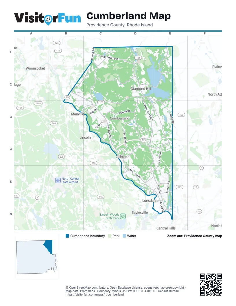
Street index of Cumberland
Each street on the sheet and the grid squares it crosses.
- Woonsocket Industrial HighwayB2
- Mendon RoadB2, C2, C3, C4, D4, E4, D5, E5
- Diamond Hill RoadC1, D1, D2, D3, D4, E4, D5, E5
- Pine Swamp RoadC1, D1
- High StreetE5, E6
- Highland Corporate DriveB2, C2
- Broad StreetD5, E5, E6
- Dexter StreetE5
- Highland AvenueE5
- John StreetE6
- Chambers StreetE6
- George Washington HighwayD4
- Lonsdale AvenueD5
- Nate Whipple HighwayD2, E2, C3, D3, E3
- Angell RoadD4
- Wrentham RoadD1
- Manville Hill RoadB3, C3
- Marshall AvenueD5, E5
- Ann and Hope WayD5, E5
- Blackstone StreetE5
- Church StreetE6
- Main Street ManvilleB3
- Cumberland RoadD1
- West Wrentham RoadC1, C2, C3
- Abbott Run Valley RoadD2, D3, E3, E4
- Scott RoadD3, D4
- Little Pond County RoadD2, D3
- Tower Hill RoadC2, D2
- Pound RoadC3, D3
- Curran RoadE5, E6
- Reservoir RoadD2, E2
- Burnt Swamp RoadE1, E2
- Hines RoadE4, E5
- Leigh RoadD3, D4
- Bear Hill RoadD4, E4
- Tingley RoadE1, E2
- Albion RoadC4
- Hillside RoadD3, E3
- North Attleboro RoadE2, E3
- America StreetB2, E6
- Torrey RoadE2
- Paine RoadE3
- Bound RoadC1
- Kay StreetC3
- Martin StreetD5
- Mill StreetE6
- Elder Ballou Meeting House RoadC1
- Mount Pleasant View AvenueC3
- Ralco WayE6
- Crowell StreetE5
- Myrtle StreetE6
- Carpenter StreetE6
- School StreetC4, E6
- West Carpenter StreetE6
- Park East DriveC2
- Brown StreetE6
- Sumner Brown RoadD1, E1
- Old Staples RoadC2, D2, C3
- Lippitt AvenueD3, D4
- Sneech Pond RoadD2, E2, C3, D3, E3
- England StreetE5
- Bryant StreetE5
- Farm DriveC3
- Thomas Leighton BoulevardD2
- Cook RoadD1
- Windsong RoadC3
- Meadowcrest DriveD5
- Sun Valley DriveE3
- Fisher RoadD1, D2
- Minerva AvenueE5
- Countryside DriveC3
- Maple Ridge DriveC1, C2
- Crestwood CourtE4
- Old West Wrentham RoadC2
- Jason Grant DriveD2
- Newell DriveE3
- Speepy Hollow DriveE3
- Lonesome Pine RoadD3, E3
- Fairhaven RoadD3, E3, E4
- Old Mendon RoadD5
- Rawson RoadE3
- Aurora DriveD4
- Silo DriveE4
- Hilltop RoadE5
- Kelsey Eden WayE2
- Crossing DriveC4, D4
- Bourque RoadD3
- Willis DriveC2, C3
- Metcalf DriveD2
- Lonsdale Farm RoadD5, E5
- New Clark RoadC3
- Scarborough DriveC3
- Vineyard AvenueE5
- Jencks RoadC1
- Louise Luther DriveE3, E4
- Industrial RoadD4, E4
- Southbury RoadC3
- Millers Brook DriveE5
- Morris StreetE5
- Ronald AvenueD3, D4
- Branch AvenueB2, B3
- Roland StreetD5
- High Ridge DriveC3
- Beach RoadD3
- Quaker RoadE2, E3
- Iroquois RoadE4, E5
- Woodside AvenueE5
- Deer Brook WayC1
- Macondray AvenueE6
- Cargill RoadE4
- Womantam LaneD2
- Terrace AvenueE5
- Howard RoadE4
- Shirley DriveD4, E4
- Alexis Donnelly WayD1
- Pollett StreetD5, E5
- Boardman AvenueC3
- Kent StreetD5, E5
- Canning StreetC3
- Arnold DriveE3
- Old Willis RoadE5
- Birch RoadD3, D4
- Redgate RoadD4
- Rolling Acres DriveC3
- Follett StreetC3
- Roosevelt RoadC3
- Titus StreetE6
- Valley Stream DriveD4
- Preserve DriveD1
- Ann StreetE5
- Circuit DriveD3, E3
- Georgiana DriveD1
- Kennedy CourtC3
- Arnold Mills RoadE2, E3
- Summit RoadD3, D4
- Hewes StreetE5, E6
- Rhode Island AvenueE4
- Circledale DriveC4
- Austin DriveD2
- Sandy WayC3
- Carlson DriveE5
- Garden StreetD5
- Bonnibrook DriveD2, D3
- Frederick LaneE3
- Thompson Hill DriveD3
- Pine RoadD3
- Streamview DriveD5
- Waumsett AvenueE4
- Orchard DriveD4
- Fairview AvenueD5
- Abbey DriveD3, D4
- Billington CircleD3
- Ferncrest DriveD4, E4
- Club DriveD3
- Forestdale DriveC4
- Broadview AvenueD4
- Front StreetD4
- Aborn AvenueB2
- Fiske AvenueC3
- Blacksmith RoadE4
- Rhodes StreetE1
- Stagecoach RoadE4
- Hadde AvenueC3
- Highland View RoadD1
- Emmett LaneE3
- Waterman StreetE5
- Garvin StreetE5
- Rabbitt Hill RoadE5
- Rocky Crest RoadC3
- Woodcrest DriveE3
- Beamis AvenueC3
- Desmarais StreetB3, C3
- Alaska StreetE4
- Hope StreetE5
- Bishop DriveE2, E3
- Greenview StreetC3
- Bruce DriveD3
- East Earle StreetE5
- Harriet LaneD4
- Gadoury DriveB2
- Notre Dame AvenueC3
- Grants Mill RoadD1
- Westwood DriveC3, C4
- Peacedale RoadC4
- Greenfield RoadD3, E3
- New York AvenueE4
- Governor StreetB2
- Clark StreetE5
- Park View TrailD3, D4
- Owen DriveD3, E3
- Ballou StreetB2
- Valley View DriveB2
- Heroux BoulevardC3
- Britts RidgeD4
- Mowry AvenueE5
- Apple Ridge RoadE4
- East Barrows StreetE5
- Tanglewood DriveD3, E3
- Forest AvenueE5, E6
- Mayflower DriveD2
- Anna Mac DriveD2, D3
- Flat StreetB3, C3
- Oakhill DriveE5
- McGirr StreetE5, E6
- Weeks StreetB2
- Buckboard DriveE4
- Murphy DriveD3
- Blissdale AvenueD5
- Apple Blossom DriveD2
- Kinsman StreetE5, E6
- Sunnyside DriveC3
- Jenna WayE4
- West Highland AvenueD5, E5
- Colonial AvenueE4
- Waterman Farm RoadE4
- Cobblestone StreetD1, D2
- Massachusetts AvenueE4
- Old Angell RoadD4
- John C Dean Memorial BoulevardD5
- WillcroftD4
- Hidden Meadow DriveE2
- Farmview DriveE3
- Holly LaneE3
- Louise AvenueB2
- Nancy DriveD3, E3
- Williams StreetE5
- Secluded CourtC3
- Grove RoadD4
- Plantation DriveC3
- Rosewood DriveE3
- Kings RowE3
- Blanche AvenueB2
- Knollcrest DriveC3
- Pequot AvenueE4
- Lantern LaneE3
- Chestnut StreetD5, E5
- Maybury StreetD5
- Cumberland StreetE5
- Vivian AvenueB2
- Fieldside DriveE3
- Girard RoadC3
- Overhill RoadD5
- Old Meadow LaneE3
- Old Whipple StreetE5
- Raymond DriveD3, E3
- Biltmore AvenueB2
- Whispering PinesB2, B3
- Leddy RoadD3
- Old Hickory DriveE3
- Stoney View DriveB3
- Brookwood LaneD4
- North Garden StreetD5
- Douglas DriveD2
- Seneca StreetD5, E5
- Cadoret DriveC3
- Abbott Valley View DriveD3, E3
- Thomas DriveD3
- Sonny DriveC3
- Amherst StreetE5
- Havens StreetE6
- Phillip AvenueE4
- The MeadowsE4
- Lyn CourtE2
- Curran Brook CourtE5
- Berm StreetD5
- Pleasant StreetE5
- White Hill LaneE3
- Elizabeth StreetE6
- Ledge View DriveD2
- Anthony DriveC4
- Main StreetD5, E5
- Wampum TrailD2
- Alton AvenueB2
- Dade RoadD4
- Doire RoadC4
- Nicholas DriveE2, E3
- Rosemere RoadC3
- Pristine DriveD2
- Hayfield LaneE3
- Oakwood AvenueE5
- Wyoming DriveE4
- Cross RoadD3, D4
- Birchwood DriveD2
- Drummond StreetD5
- Legion AvenueC3
- Mullen StreetC3
- Morning Glory RoadB3
- Tuscan CourtD3
- Olive StreetB2, D5
- Bayberry Hill DriveE3
- Victory StreetD5
- Sherman AvenueB2
- Woodland StreetD5, E5
- Barn DriveE3
- West Earle StreetE5
- Ridgeland DriveE3
- Esek Hopkins LaneE3
- Rustic LaneD1
- Hatch StreetE6
- Prospect StreetE6
Places on the map
- Arnold Mills Reservoir
- Ash Swamp
- Beacon Pole Hill
- Bear Hill
- Beauregard Loop
- Blackall Family and Ballou Farm Preserve
- Blue Trail
- Brush Hill
- Carls Pond
- Catamint Brook Preserve
- Catamint Hill
- Copper Mine Hill
- Cumberland High School
- Cumberland Hill
- Cumberland Monastery
- Cumberland Post Office
- Diamond Hill
- Diamond Hill Park
- Diamond Hill Reservation
- Diamond Hill Reservoir
- Garvin Memorial School
- Geddes Bowen Preserve
- Happy Hollow Pond
- High Rock Preserve
- Howard Pond
- Hunting Hill
- Iron Rock Hill
- J.H. Lynch & Sons
- Little Pond
- Mercy Loop
- Mercy Woods Preserve
- Mercymount Country Day School
- Miscoe Lake
- North Cumberland Middle School
- Pine Swamp
- Rawson Pond
- Scott Brook Preserve
- Sneech Pond
- Valley Falls
- Yellow Trail
Next to Cumberland
- Albion
- Central Falls map
- Lincoln map
- Lonsdale
- Manville
- Plainville
- Saylesville
- Woonsocket map
© OpenStreetMap contributors, Open Database License, openstreetmap.org/copyright · Map data: Protomaps · Boundary: Who's On First (CC-BY 4.0); U.S. Census Bureau















