

Rhode Island map
Tiverton map
About 15,938 people live here (Census Bureau, 2024 estimate). The sheet's index lists 300 streets; Main Road, Crandall Road and Bulgarmarsh Road cross the most grid squares. Things to do inside the boundary: Bally's Tiverton Casino and Hotel.
Open the map (PDF, US Letter)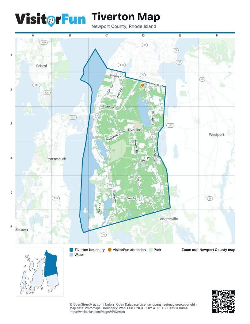
Street index of Tiverton
Each street on the sheet and the grid squares it crosses.
- RI 138C3
- RI 24C3
- Main RoadC1, C2, C3, C4, C5, C6
- Crandall RoadD3, D4, D5, E5
- Fish RoadC2, D2, C3
- Bulgarmarsh RoadC3, D3, E3, C4
- Stafford RoadD2, D3
- East RoadC5, D5
- Stone Church RoadD5, D6
- William S Canning BoulevardD2
- Lake RoadD4, D5
- Brayton RoadD3, D4
- Nanaquaket RoadC3, C4
- Highland RoadC3
- King RoadD4
- Riverside DriveC3
- Central AvenueC3
- Evans AvenueC3
- Long HighwayD6
- Seapowet AvenueC4, C5
- Neck RoadC5, C6
- Eagleville RoadC2, D2
- Eight Rod WayC5, D5, D6
- Cornell RoadD3, D4
- East End Sportsmans Club RoadD2, E2
- Canonicus StreetC2, D2
- Arruda's LaneD2, E2
- Hooper StreetC2, D2
- Three Rod WayD2, B5, B6, C6
- Judson StreetC2
- Southlake RoadD5, D6
- Village RoadC2
- Souza RoadC2, C3
- Corys LaneD2, D3, E3
- Cottrell RoadC3
- Captains CircleD3, E3
- Pocasset Hill CemeteryC2
- Bettencourt LaneC5, C6, D6
- Winnisimet DriveC4
- Progress RoadC3, D3
- Bridle WayD3, E3
- Hilton StreetC1, C2
- Deer Run RoadD4
- Bonniefield DriveC5, C6
- Hurst LaneD2
- Schooner DriveC2
- Stony Hollow RoadD5, E5
- Lepes RoadC2
- Holly CircleC3, D3
- Old Main RoadC2, C5, C6
- Hancock StreetD2, E2
- High Hill RoadC6
- Pond Bridge RoadC6
- Industrial WayC3
- Fairwood DriveD3
- Robert Gray AvenueC2
- Indian Point RoadC4
- Warren AvenueC2
- North Brayton RoadD3
- Bracket AvenueC2
- Russell DriveC2
- Ledoux LaneD5
- Mill StreetC2
- Pelletier LaneD2
- Kaufman RoadC2
- Fogland RoadC6
- Kearns AvenueC2
- Lafayette RoadC4, D4
- Ford Farms RoadC2
- Laura LaneC4
- Sakonnet Ridge DriveC3
- Beardsworth RoadC2
- Field Stone LaneD5
- Merritt AvenueC2
- Church StreetC1, C2
- Colonial AvenueC2
- Briarwood AvenueC2
- Christopher AvenueD3
- Woodland CircleD4
- Highland CourtC3
- Randolph AvenueC2
- Horizon DriveC2
- Hayden AvenueC2
- Shove StreetC1, C2
- Church Pond DriveC3
- Leeshore LaneC2
- Furey AvenueD4
- Narrow AvenueD4
- South Christopher AvenueD3
- Bay StreetC1, C2
- Old Bulgarmarsh RoadC3, C4
- Elk DriveD3
- Tiverton Casino BoulevardD2
- Lyne RoadD3
- Sawdy Pond AvenueD3, D4
- Montgomery StreetD3
- Old Stafford RoadD3
- Thibault LaneD2, D3
- Leger LaneD3
- Lazywood LaneD3
- Michaels LaneD5, E5
- Quintal DriveD3
- Richard DriveC2
- Preservation WayD5
- Abel Hart LaneD5
- Bellview AvenueC2
- Beech AvenueC2
- Songbird LaneD2
- Texaco Service RoadC2, D2, C3
- Penny Pond RoadC4
- Bud WayC3
- Wampanog LaneC5
- Tower Hill RoadD3
- Durfee RoadC2
- William Barton DriveC3
- John Duggan RoadC2
- Haskins AvenueC2
- Bolduc LaneD3
- Chace AvenueC1, C2
- Lawton AvenueC3
- Blueberry LaneD4
- Sylvia RoadD5
- Forand LaneD3
- West Demello DriveD5
- Saxony AvenueD5, E5
- Pocasset AvenueC2
- North CourtC4
- Bottom StreetC1, C2
- Harbor Ridge LaneC2
- Lark LaneD2
- Waters EdgeC2
- Bears Den RoadD2
- Brookside DriveC6
- Peaceful WayC5
- State AvenueC1, C2
- Hambly RoadC2
- Evergreen AvenueC2
- Jiley Hill DriveC3
- Cypress AvenueC2
- Meadow View LaneD3
- Fir AvenueC2
- Maple DriveD4
- Barnswallow DriveC5
- Grinnell AvenueC2
- Watuppa AvenueE2
- Mark DriveD3
- Dadson Mobile EstatesC3
- Topsail DriveC2
- Campion AvenueD3
- Lawrence CourtC4
- Arbor TerraceC2
- Crest RoadD4
- East Demello DriveD5
- Caribou WayD3
- Middle AvenueC3
- Louise DriveC2
- Driftwood DriveC5
- Hobson AvenueC2
- Watermark DriveC2
- Lewis StreetC2, C3
- Old Colony TerraceC2
- Shannon AvenueC2, C3
- Margaret StreetD3
- Quaker AvenueC3
- Cardinal CourtD2
- Poplar DriveC2, C3
- Bryant LaneD2
- Vitruvian WayD3
- Kenyon Road EastC2
- Linda RoadC2
- Dion AvenueD5
- Sandra Lee LaneD5, E5
- Leonard DriveC4
- Clegg AvenueC2
- Daniel T Church RoadC3
- South AvenueC3
- Dewey AvenueC2
- Gadsby LaneC5
- Bramble WayC2
- Kenyon RoadC2
- Doris AvenueC2
- Ridgeside LaneC3, D3
- Ash AvenueC2
- Sleepy Hollow RoadD5
- Thomas StreetD4
- Lucy AvenueC3, C4
- Bucks WayD4
- Mountain Laurel LaneC3
- Pershing AvenueD3
- Wood AvenueD4
- Riverscape LaneC4
- Cedar Field RoadC3
- Aquidneck DriveD2
- Borden RoadC2
- Restful Valley RoadD3
- East King RoadD4
- Morckingbird LaneD2
- Cutter LaneC2
- Tucker AvenueC3
- Florence StreetD3
- Robin LaneD2
- Terra Verde DriveD3
- April LaneC3
- Bullfrog LaneE2
- Charles DriveC2
- Pool LaneD5, E5
- Raiders WayC3
- Cross RoadD4
- Adelard AvenueD4
- Christina DriveD5
- Old Farm LaneD5
- Rhododendron DriveD4
- Bismark AvenueC2
- East Bourne AvenueC2
- Roseland TerraceD5
- Massey RoadC2
- Bridgeport RoadC3
- Hillside AvenueC3
- Coral LaneD3
- Delano Island StreetC4
- Walnut StreetC2
- Point View DriveB5, B6
- Prospect HillC3
- Alexandra CircleC3
- Tanglewood DriveD3
- Cliff StreetC1, C2
- Carpenter StreetC1, C2
- Roseland DriveD5
- Anthony WayC6
- Sunset View DriveC4
- Kevin DriveD3
- Morning Dove DriveC5, D5
- Cynthia AvenueD3, D4
- Cherry LaneE2
- Long Pasture WayC5
- Sheldon StreetD2
- Nonquit LaneC5
- Arrowhead DriveC4
- Nicholson PlaceC3
- Birch StreetC2
- Last StreetC2
- Old Eagleville RoadD2
- Red Tail TrailD2
- Summit AvenueC3
- Beth RoadC2
- Pierce AvenueC3
- Wood Lily LaneD3
- Blackbird CourtD2
- Isabella DriveD4
- Sachem RoadC4
- East Dion AvenueD5
- Fairfield AvenueC4
- Jefferson StreetD2
- Cheryl DriveC2
- Briggs LaneD2
- Bourne AvenueC2
- Windmill Hill RoadC6
- Lakeside DriveD3
- Marlynn DriveC4
- Old Stone Church RoadD6
- Paul James DriveC2
- Island View DriveC4
- Roosevelt AvenueD3
- Adam StreetD2
- Persimmon DriveD3
- Lee WayD2
- Sunderland HeightsC3
- Farnum StreetD2
- Slade StreetD3
- Reed StreetC3
- Mathew RoadC2
- Francis LaneC6
- Plantation DriveE2
- Windwood DriveD3
- Glendale StreetD3
- Narragansett AvenueC3
- Poplar StreetE2
- Faria WayC6
- Yardarm DriveC2
- Riverview AvenueC3
- Kenny DriveD3
- Knotty Pine RoadD3
- Silver Beech RoadC3
- Arrudas LaneD2
- Harris DriveC2
- Bluff AvenueC3
- Corey's LaneD3, E3
- Hope StreetC2
- Pelham RoadD3, D4
- Urban's LaneD2
- Lake AvenueE2
- Jacqueline WayD5
- Bobbin Hill RoadC3
- Indian Hill RoadD3
- Laura StreetC2
- Alan StreetC2
- Blossom LaneE2
- Borden LaneD2
- Bowen AvenueC3
- Wildrose DriveD5
Things to do on the Tiverton map
Places on the map
- Aspire Dermatology
- Bulgarmarsh Recreation Area
- Congregational Cemetery
- Cook Hill
- Eight Rod Farm
- Emilie Ruecker Wildlife Refuge
- Fogland Beach Conservation Area
- Fogland Marsh Preserve
- Fort Barton/Sin And Flesh Brook Natural Area
- Friends Burial Ground
- Gray's Ice Cream
- Grinnell's Beach
- Highland Woods
- Hillside Cemetery
- Holy Ghost Catholic Church
- Holy Trinity Episcopal Church
- Jiley Hill
- Mary C Donovan Marsh
- Nannaquaket Hill
- Nannaquaket Pond
- Nonquit Pond
- Pardon Gray Preserve
- Pleasant View Cemetery
- Pocasset Cedar Swamp
- Pocasset Hill
- Pocasset Hill Cemetery
- Pocasset Ridge Conservation Area
- Recreate Town Farm
- Sandywoods / Bossom
- Seapowet Marsh Management Area
- Stafford Pond
- Tiverton High School
- Tiverton Middle School
- Tiverton Post Office
- Tiverton Quarry
- Town Farm
- Weetamoo Woods
- Wilcox Hill
Next to Tiverton
- Adamsville
- Bristol map
- Middletown map
- Portsmouth map
- Westport
© OpenStreetMap contributors, Open Database License, openstreetmap.org/copyright · Map data: Protomaps · Boundary: Who's On First (CC-BY 4.0); U.S. Census Bureau















