

South Carolina map
Georgetown County map
About 66,035 people live here (Census Bureau, 2024 estimate). The sheet's index lists 300 streets; Ip Canal Road, County Line Road and Choppee Road cross the most grid squares. Things to do inside the boundary: Brookgreen Gardens, Huntington Beach State Park and Murrells Inlet MarshWalk.
Open the map (PDF, US Letter)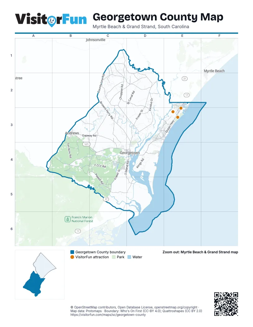
Street index of Georgetown County
Each street on the sheet and the grid squares it crosses.
- Ocean HighwayD3, E3, D4
- County Line RoadC1, C2, B3, C3, A4, B4
- North Fraser StreetD2, D3, D4
- South Fraser StreetC4, D4, C5
- Highmarket StreetC4, D4
- Browns Ferry RoadC2, C3, D3
- Georgetown HighwayB3, B4, C4
- Saints Delight RoadB4, C4
- Highway 17E2, E3
- Church StreetC4, D4
- Hagley DriveD3
- Sylvan L. Rosen BridgeD4
- West Main StreetB3
- East Main StreetB3
- Burgess RoadE2
- Highway 701 SouthD2
- L. H. Siau BridgeD4
- US Highway 521B3
- State Highway 41C2
- Choppee RoadC1, C2, C3, D3
- Pleasant Hill DriveC2, D2
- Kings River RoadD3, E3
- US 17 BusinessE2, E3
- Waverly RoadD3, E3
- Willbrook BoulevardE3
- Front StreetC4, D4
- South Morgan AvenueB3
- North Morgan AvenueB3
- Black River RoadD4
- Sunnyside AvenueE2
- Gandy DriveB3
- Saint James StreetD4
- Hemingway HighwayC1
- Thurgood Marshall HighwayB3
- Plantersville RoadC2, D2, D3
- Old Pee Dee RoadC1, D1, D2
- Gapway RoadB3, C3, C4
- Carvers Bay RoadC2, D2
- Powell RoadC4, C5
- Indian Hut RoadC3, C4
- Pennyroyal RoadC4
- Rose Hill RoadC2
- South Island RoadC4, D4, C5, D5
- Exodus DriveD2, D3
- Walker RoadB4, C4
- Johnson RoadC3, C4
- Frank Cribb RoadC2
- Kent RoadB3, B4, C4
- Luvan BoulevardD4
- Gallop RoadB3, B4
- North Santee River RoadC5, D5
- Dunbar RoadC2, C3
- Bullard RoadC1, C2
- Big Dam Swamp DriveB3, C3
- Estherville DriveD5
- Center RoadC2, C3
- Folly Grove RoadC1, C2
- Williams Hill RoadC1
- South Waccamaw DriveE2, E3
- Barnhill RoadC1, C2
- Dave McKenzie DriveB4
- Columbus RoadB4, C4
- Dawhoo Lake RoadB4
- Debordieu BoulevardD4
- Wachesaw RoadE2, E3
- Petigru DriveD3, E3
- Old Kings HighwayE2, E3
- Woodland AvenueC4
- Topsaw AvenueD2
- Wesley RoadE3
- Tom Cribb RoadD2
- Mt Zion AvenueC5
- Myrtle AvenueD3, E3, D4
- Buorton RoadD2
- Gasque StreetB4
- Pickerel RoadC4
- Browns Chapel RoadA4
- Ethridge DriveC3
- Harris Landing RoadC5
- Oatland RoadC3
- Murrells Inlet RoadE2, E3
- Martin Luther King RoadD3, E3
- Norris DriveE3
- Prince Creek ParkwayE2
- Veronica RoadC5
- South Causeway RoadD3, E3
- Blue Stem DriveD3
- Beaumont DriveD3
- Martin Luther King DriveB3
- Tyson DriveD3
- Anthuan Maybank DriveD4
- Ethridge RoadC3
- North Hazard StreetD4
- Old Town AvenueC4
- Pendergrass AvenueE3
- West Church StreetD4
- Wood StreetD4
- Dillion DriveC3
- Bellamy AvenueE2
- Litchfield DriveE3
- Pope RoadC1
- Macklen AvenueE2
- Lafayette StreetD4
- Journeys End RoadE2
- Reservoir StreetC4
- Seaboard RoadB3
- Pavilion LaneE3
- Santee RoadA4
- Bluestem DriveD3
- Ip Canal RoadD1, C2, D2, C3, D3, C4, D4
- Ten Acre RoadB3, B4
- East CCC RoadC4
- Bluff RoadB4, B5
- Jackson Village RoadD2, D3
- Squirrel Run RoadC2
- Kings RoadD4
- Yawkey Way SouthD5
- Brick Chimney RoadC3, D3, C4
- Vanderbilt BoulevardD4
- Tomahawk StreetC1
- Hobcaw RoadD4
- Calvin Hardee RoadD3
- Hesterville RoadC3
- School House RoadC1, D1, C2
- Bigelow DriveB4
- North Boundary RoadD4
- Reserve Bank RoadD4
- Whitehall AvenueC4, D4
- Wedgefield RoadD3
- Eaddy RoadD2, D3
- Wallace Pate DriveD4
- Old Tram RoadD2
- Tyler DriveC2, D2
- Riverwood DriveE2
- Dillon DriveC3
- Colonel Cole DriveC3, D3
- Amos RoadC3
- Jerusalem DriveC1
- Peters Creek RoadD3
- Club CircleD3, E3
- Prince StreetC4, D4
- Disher StreetC4
- Floating Bridge RoadD4
- Ray RoadC1
- Sandy Island RoadE3
- Sandhole RoadB4
- Waterford RoadD3, D4
- Corner LoopC5
- County Road S-22-376D3
- Pringle Ferry RoadD3
- Duke StreetC4, D4
- Crabhaul RoadD4
- Hill DriveD2, D3
- Lambert LoopB4
- Wild Horse RoadB4
- David W Ray RoadD3
- Tallowtree DriveB3, C3
- Rimini DriveC3
- Pond RoadE2
- Hanna LoopC2
- Montford RoadC4
- Lawshe RoadC3
- Clarence DriveC3
- Hawthorn DriveD3, E3
- Heritage Plantation DriveD3
- Mauresina RoadC4
- Oaks Plantation DriveC5
- Nightingale DriveD3
- Benton Williams RoadC2, C3
- Retreat Beach CircleE3
- Snowden DriveC2
- Clambank RoadD4
- Liston DriveC2
- Tradition Club DriveE3
- McDonald RoadC4
- Willard LoopC2
- Garrison RoadC3, C4
- Mansfield RoadD3
- Frances Marion DriveC3
- Puncheon Creek DriveB3
- Aviation BoulevardC4, D4
- Blanche DriveC2
- Weehaw Plantation DriveD3, D4
- White House RoadD3
- Oatland Lake DriveD3, E3
- Friendfield StreetC4
- Upper Topsaw RoadD2
- Cohen DriveD2
- Bromell AvenueD2
- Red Bluff RoadC4
- Laser RoadC4
- Chicora Wood AvenueD3
- Landfill DriveC3
- Hangar RoadD4
- Mobley RoadC3
- Boxwood DriveB3
- William Alston LoopE3
- Wister RoadC1, D1
- Munnerlyn LaneC2, C3
- Isaac DriveC2
- Ballentine DriveC3
- Mazyck DriveC5
- Carriage Run CircleE2, E3
- Lanes Creek DriveC3
- Palmer DriveC2
- Devil's Dining Room RoadC4
- Knowlin RoadB4, C4
- Bates Hill RoadD2
- Weymouth DriveD3
- Crooked Oak DriveE3
- Hogpen RoadD4
- Porter RoadB4, C4
- Gallop LaneB4
- Ports Hill DriveC1, D1
- Postfoot CircleC3
- Lucy Grier DriveD2
- Pump House Landing RoadC3
- Johnnys River RoadC4
- Jetty DriveE3
- Sunfish StreetE2, C4
- Altman AvenueC2
- New River RoadE2, E3
- Holly Grove DriveD2
- Old Plantation DriveD3
- Arcadia Plantation DriveD4
- Robinson RoadB3
- Hebrew CourtD3
- Annadale RoadD5
- Bellefield RoadD4
- Fir DriveC4
- Cravens StreetD4
- Terrapin RoadE3
- Rocky Point DriveC2, C3
- Belle Isle RoadC4, D4
- Benvenue AvenueD3
- Cedar AvenueB3
- Jacobs AvenueC4, D4
- Parker DriveE3
- Firethorne DriveE2
- Highwood CircleE2
- Mt Pleasant DriveC3
- Whiteville DriveC2
- South Beech AvenueB3
- Wilmer Cannon RoadB4
- Henry RoadD2
- Dorien DriveA4, B4
- Collins Meadow DriveD4
- Alligator LaneB3
- Sollie CircleC4
- Crow Hill DriveC5
- Francis Parker RoadD3
- Old Charleston RoadC4, D4
- Ford Village RoadD2
- Ramsey Grove RoadD3
- Deas DriveB4
- Pawleys Plantation WayD3
- Taylor RoadC1, C2
- Marsh RoadD4
- Frontage RoadE2, E3, D4
- Rural Hall DriveC3
- Latana CircleD4
- Harvest Moon DriveD4, D5
- Brookgreen DriveE3
- Turntable RoadE3
- Canteen LaneC3
- Winyah StreetC4, D4
- Boomer DriveD2
- Doral DriveD3
- Old Clubhouse CornerD4
- Country Club DriveE3
- South Poplar AvenueB3
- West Elmwood StreetB3
- Richmond Hill DriveE2, E3
- South Bay StreetD4
- South Farr AvenueB3
- Ingleside RoadD3
- Darthez RoadD4
- Log Cabin RoadD4
- Pine Tree Landing RoadB3
- Plantation BoulevardD4
- Joe DriveB4
- Hicks DriveD2
- Heriot Farms DriveD5
- Bombing Range RoadD3
- Village RoadC4
- Summit AvenueD4
- Fringetree DriveE2
- Antwine DriveC2
- Golden Bear DriveD3, D4
- Emanuel StreetC4, D4
- Dune Oaks DriveD4
- Deep Creek DriveC1
- Noah's Mill RoadC2
- Hamlin RoadC3
- Stephen DriveC2
- Hayfield RoadC2
- Woodberry DriveC1
- Exchange DriveD3
- Fuzzy Swamp RoadD4
- Greentown RoadC4
Things to do on the Georgetown County map
Places on the map
- Andrews
- Big Kilsock Bay
- Boety Bay
- Brookgreen Gardens
- Broton Lake
- Butler Island
- Camp Bay
- Canaan Bay
- Cape San Roman Beach
- DeBordieu Beach
- Debordieu Club
- Gapway Bay
- Garden City Beach
- Georgetown
- Georgetown County Airport
- Goat Island
- Heritage Club
- Horse Swamp
- Huntington Beach
- Joe Bay
- Litchfield Beach
- Litchfield Country Club
- Little Crow Island
- Little Kilsock Bay
- Mackey Bay
- Murrells Inlet
- North Island Beach
- North Litchfield Beach
- Pawleys Island
- Pawleys Island Beach
- Pee Dee Swamp
- Prince George Beach
- Robert F. Swinnie Airport
- Sandpiper Pond
- The Reserve Golf Club
- The River Club
- Tradition Golf Club
- True Blue Golf Plantation
- Wachesaw Plantation Club
- Wachesaw Plantation East
Next to Georgetown County
- Johnsonville
- Myrtle Beach
© OpenStreetMap contributors, Open Database License, openstreetmap.org/copyright · Map data: Protomaps · Boundary: Who's On First (CC-BY 4.0); Quattroshapes (CC BY 2.0)