

South Carolina map
Greenville map
About 74,371 people live here (Census Bureau, 2024 estimate). The sheet's index lists 300 streets; North Pleasantburg Drive, Woodruff Road and Parkins Mill Road cross the most grid squares. Things to do inside the boundary: Bob Jones University Museum and Gallery, Falls Park on the Reedy and Greenville County Museum of Art.
Open the map (PDF, US Letter)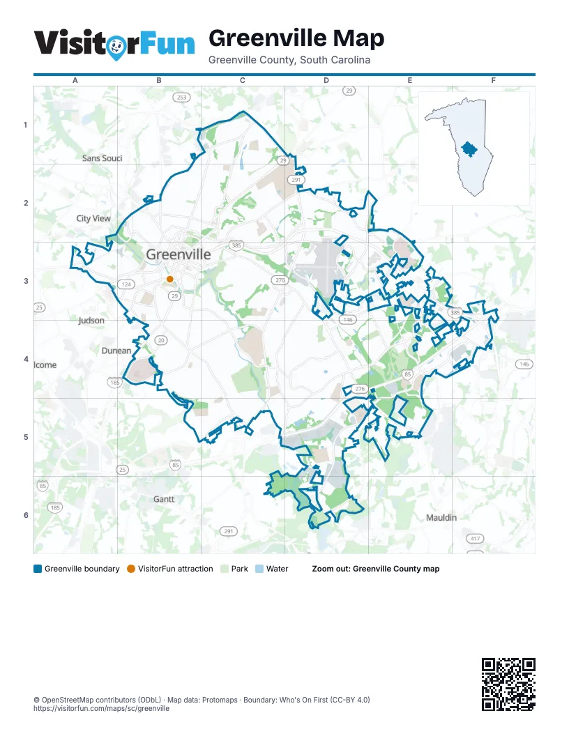
Street index of Greenville
Each street on the sheet and the grid squares it crosses.
- Laurens RoadC3, D3, D4, E5
- North Pleasantburg DriveC1, D1, D2, C3, D3
- East North StreetC2, D2, B3, C3
- Augusta StreetB3, B4, C4, C5
- South Pleasantburg DriveC3, D3, C4, C5
- Wade Hampton BoulevardC1, D1, C2
- South Academy StreetA3, B3
- South Church StreetB3, B4
- Mauldin RoadC5, D5, D6
- North Academy StreetB2, B3, C3
- North Church StreetB2, C2, B3
- East Stone AvenueB2, C2, C3
- Mills AvenueB4
- Rutherford StreetB2
- West Stone AvenueB2
- Buncombe StreetB2, B3
- Beattie PlaceB3, C3
- Eastlan DriveC3, D3
- College StreetB2, B3
- Easley Bridge RoadA3
- Augusta RoadC5
- West North StreetB3
- Pine Knoll DriveD1
- Poinsett HighwayB2
- Woodruff RoadD3, E3, D4, E4, F4
- Verdae BoulevardE3, D4, E4
- Haywood RoadD2, E2, D3, D4
- Pelham RoadD2, E2
- Fairforest WayD5, E5, D6
- West Faris RoadB4
- East Faris RoadB4, C4
- Grove RoadB4
- Pendleton StreetA3, B3
- Congaree RoadD3, E3
- South Main StreetB3
- Roper Mountain RoadE3
- Pete Hollis BoulevardB2
- Frontage RoadE3, E4
- Patewood DriveE2, E3
- Woods Crossing RoadD3, E3
- Anderson StreetB3
- River StreetB3
- Roper Mountain Road ExtensionE2, E3
- Falls Park DriveB3
- Henrydale AvenueB4
- Anderson RoadB3
- North Main StreetC1, B2, C2, B3
- Parkins Mill RoadD3, C4, D4, C5, D5
- Cleveland StreetB3, C3, C4
- Rutherford RoadB1, C1, B2
- Carolina Point ParkwayE4, F4
- Millennium BoulevardE4, E5
- Lowndes Hill RoadC2, D2, C3, D3
- Ridge RoadD4, D5, D6
- Duvall DriveD4, C5, D5
- East Washington StreetB3, C3
- Salters RoadE3, E4
- Keith DriveC2, C3, D3
- Airport RoadD3
- McDaniel AvenueB3, B4
- West Washington StreetB2, B3
- Chick Springs RoadC1, C2
- Old Sulphur Springs RoadE3, E4
- Halton RoadD3, E3
- East Parkins Mill RoadD4, D5
- Independence BoulevardE3, F3
- Woods Lake RoadD2, D3
- Cleveland Street ExtensionC4, D4
- Henderson RoadD4
- Rocky Slope RoadD3, E3, E4
- Market Point DriveE4, F4
- Potomac AvenueB5, C5
- Townes StreetB2, B3
- University RidgeB3
- Mohawk DriveC2
- Green AvenueB3
- Byrdland DriveD3
- Dunbar StreetA3, B3
- Mall Connector RoadE3
- Overbrook RoadC2
- Century DriveC2, D2
- East Park AvenueB2, C2
- East McBee AvenueB3, C3
- Orchard Park DriveD2, E2, E3
- Prosperity AvenueC5
- East Broad StreetB3
- Saint Josephs DriveD4, D5
- West Broad StreetB3
- South Hudson StreetB3
- Parallel ParkwayE4
- Hillside DriveC2, C3
- North Calhoun StreetB3
- Woodruff Industrial LaneE4, F4
- Industrial DriveD3
- West Antrim DriveC3
- South Calhoun StreetB3
- Vardry StreetB3
- West McBee AvenueB3
- North Markley StreetB3
- Falls StreetB3
- Butler AvenueB2, B3
- East Camperdown WayB3
- East Antrim DriveC3, D3
- West Park AvenueB2
- Williams StreetC3
- Richardson StreetB3
- Garlington RoadF3, F4
- Green Heron RoadE4
- Pendleton RoadA3
- Guess StreetB3, B4
- Brookway DriveB4
- Keys DriveE3
- Atwood StreetB2
- North Spring StreetB3
- Shaw StreetB2
- Ketron CourtE3, E4
- Buncombe RoadB2
- Lynn StreetB4
- Lois AvenueA3
- Transit DriveD3
- University StreetB3
- Hudson RoadE2
- Nelson StreetB3
- Woodside AvenueA3
- South Richardson StreetB3
- South Spring StreetB3
- Edwards RoadD1
- Miller RoadF4
- Piney Mountain RoadC1
- Summit DriveC1, C2
- Pimlico RoadD4
- Wembley RoadD3, D4
- Villa RoadD2
- Woodland WayB3, C3
- Crescent AvenueC3, B4, C4
- Innovation DriveE4, E5
- Perry AvenueA3, B3
- Dairy DriveD5
- Rockwood DriveB4, C4, B5
- Woodlark StreetC3, D3
- Hampton AvenueB2, B3
- Byrd BoulevardC4, C5
- Bennett StreetC2
- Tower DriveD3
- Rockingham RoadC4, C5, D5
- Riverside DriveC4, C5
- Carolina AvenueD3, D4
- Meyers DriveB4, C4
- Faris CircleC4
- Creekridge RoadE4
- Twin Lake RoadC1
- Don DriveC4, D4
- Dellwood DriveC1, C2
- Glenn RoadC3, C4
- Wenwood RoadD5
- Club Forest LaneB4, B5
- Spartanburg StreetC2
- Algonquin TrailD4, E4
- Cleveland Park DriveB3, C3
- Jones AvenueB3, B4
- Lakehurst StreetC3
- Ridgeland DriveB3, C3
- Aberdeen DriveB4
- Webster RoadC3
- Ashley AvenueB2
- Pinckney StreetB2
- Welling CircleD4, E4
- Pleasant Ridge AvenueB5, C5
- Rock Creek DriveC4
- Scarlett StreetC3, C4
- Lowndes AvenueC2, C3
- Longview TerraceC4
- Bradley BoulevardC1, C2
- Old Augusta RoadC5
- Melville AvenueB4
- Waccamaw AvenueB4
- Fernwood LaneC3
- Wedgewood DriveC1
- Club DriveC4, C5
- Stonehaven DriveC4
- Arlington AvenueA3, B3
- Willow Springs DriveC3, D3, D4
- Legrand BoulevardC3, C4, D4
- Lake Forest DriveC1, C2
- Buist AvenueB2
- Enterprise BoulevardE2, E3
- Croft StreetB2
- Sycamore DriveD3
- Parkins Lake RoadD4, D5
- West Hillcrest DriveB2, C2
- West Mountainview AvenueB2
- Wilton StreetB2
- Welborn StreetB3
- Long Hill StreetB5, C5
- Babbs HollowD4
- Holmes DriveC1, C2
- Gower StreetA3, B3
- White Oak DriveC2
- Windfield RoadC4, D4
- Quail Hill DriveD5
- Woodland Way CircleB3, C3
- Augusta CourtB4, C4
- Pettigru StreetB3, C3
- Birnie StreetA3, B3
- West Earle StreetB2
- Dallas RoadE5
- Rice StreetC4, C5
- Brookside CircleC2
- McAlister RoadC3, C4
- Ackley RoadC3
- Global DriveD5
- Batesview DriveC2
- Willard StreetB2, A3, B3
- Eisenhower DriveC3, D3
- Buckingham RoadD4
- Mayberry StreetB3
- Rhett StreetB3
- Stadium View DriveC2, D2
- Azalea CourtD2
- Traction StreetA3
- Briarcliff DriveC2, C3
- Stone Lake DriveC1
- Sunset DriveB4
- East Tallulah DriveC4
- Collins Creek RoadD4
- Dupont DriveC2
- Broughton DriveC1
- Haywood Crossing DriveD3
- Marshall Bridge DriveC5
- East Hillcrest DriveC2
- Independence PointF3
- Brookdale AvenueD3
- Ashford AvenueC2
- Mount Vista AvenueC4
- Ridgecrest DriveC2
- Chisolm TrailD5
- Tomassee AvenueB4
- Glen Forest DriveD3
- Greenacre RoadC3
- Hialeah RoadD4
- Isbell LaneD4, D5
- South DriveC2, D2
- Verdae Crest DriveE4
- East Main StreetA3
- Worley RoadB1, C1
- McIver StreetB3, C3
- Randall StreetB2
- Cammer AvenueC4, B5
- Belmont AvenueB3, B4
- Lanneau DriveB4, C4
- Cureton StreetB4, C4
- Boxwood LaneC3
- Poinsett Bridge WayE5
- Woodvale AvenueC4
- Azalea Hill DriveE4
- Forest LaneB4
- Oscar StreetB2, B3
- Queen StreetA3
- Westview AvenueC2
- Sullivan StreetB3
- Cavalier DriveD5
- Douglas W Brister BoulevardC4
- Alister DriveD4, E4
- West Circle AvenueC2
- Robin Hood RoadC4
- McDonald StreetC2
- Lullwater RoadC2
- Pine Forest DriveC3, C4
- Asbury AvenueB2, B3
- Thurgood Drive ExtensionD5, E5
- Battery Creek DriveE5
- Tindal AvenueB3, B4
- West Prentiss AvenueB4
- International DriveE3
- Gilfilling RoadC2
- East Earle StreetB2, C2
- Stephens LaneC1, C2
- Keowee AvenueB4
- Shallowford RoadD4
- Watts AvenueB3
- Alpine WayC1, C2
- Old Airport RoadD3
- Capers StreetB3, B4
- Mulberry StreetB2
- Clark StreetC3
- Danvers RoadE3, E4
- Wilshire DriveC1
- Orange StreetB2
- Dogwood LaneC3
- Jenkins StreetB3
- Briarview CircleD2
- North Leach StreetB3
- Faculty RowD1, D2
- White Oak RoadC1, C2
- Prancer AvenueB5, C5
- Wilkins StreetB3, B4
- Richland Creek DriveC1
- Fluor Daniel DriveD3, E3
- Hemlock DriveC3
- McDaniel GreeneB3
Things to do on the Greenville map
Places on the map
- Alumni Stadium
- Bob Jones University
- Centre Stage
- Christ Church School
- Cleveland Park
- Collins Lake Dam
- Conestee Park
- Falls Park
- Foothills Plaza
- Forest Park
- Greenville Convention Center
- Greenville County Courthouse
- Gunter Theatre
- Haywood Mall
- Hooper Planetarium
- Independence Corporate Park
- J L Mann High School
- Legacy Academy
- Magnolia Park
- McAlister Square
- Prisma Health Greenville Memorial Hospital
- Rebel Rabbit
- Reedy River
- Revel Event Center
- Riverside Golf Course
- Rodeheaver Auditorium
- Roper Mountain Science Center
- Shops at Greenridge
- South Ramp
- Special Services Corporation
- St Francis Millennium
- St. Francis Eastside
- Stratton Hall
- The Gallery
- The Gassaway Mansion
- The Mockingbird
- The Preserve at Verdae Golf Club
- Timmons Park
- Tower Ramp
- Trailside at Halton
Next to Greenville
- City View
- Dunean
- Gantt
- Judson
- Mauldin
- Sans Souci
- Welcome
© OpenStreetMap contributors, Open Database License, openstreetmap.org/copyright · Map data: Protomaps · Boundary: Who's On First (CC-BY 4.0); Quattroshapes (CC BY 2.0)