

Tennessee map
Knoxville map
About 198,722 people live here (Census Bureau, 2024 estimate). The sheet's index lists 300 streets; Knoxville Bypass, Pellissippi Parkway and North Broadway cross the most grid squares. Things to do inside the boundary: Knoxville Museum of Art, Muse Knoxville and Sunsphere.
Open the map (PDF, US Letter)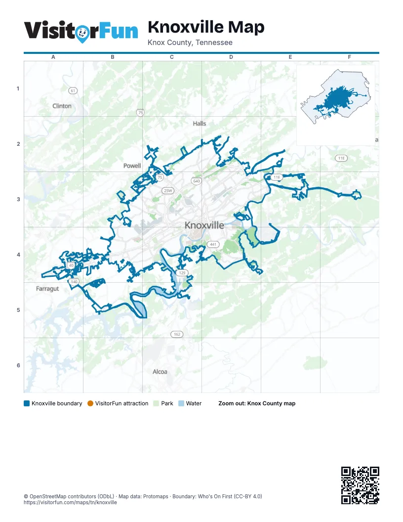
Street index of Knoxville
Each street on the sheet and the grid squares it crosses.
- Knoxville BypassD2, C3, D3, C4
- Pellissippi ParkwayA4, A5, B5, C5
- Alcoa HighwayC3, C4, C5
- James White ParkwayD3, D4
- Neyland DriveD3, C4, D4
- Alcoa Highway Frontage Road NorthC4
- Alcoa Highway Frontage Road SouthC4
- Frontage Road NorthC4
- East Topside Road ConnectorC5
- James White Parkway / Summit Hill DriveD3
- Kingston PikeA4, B4, C4
- Asheville HighwayD3, E3
- Rutledge PikeD2, E2, D3
- North BroadwayC2, D2, C3, D3
- Western AvenueB3, C3, D3
- Clinton HighwayB3, C3
- Chapman HighwayD4, E4
- East Magnolia AvenueD3
- Hall of Fame DriveD3
- Martin Luther King Jr AvenueD3
- Greenway DriveD2, D3
- Cumberland AvenueC3, D3, C4
- Maynardville PikeD2
- Henley StreetD3, D4
- Ailor AvenueC3, C4
- Dale AvenueC3
- Oak Ridge HighwayB3
- Main Street WestD3
- Timothy StreetD3
- Broadway ViaductD3
- South BroadwayD3
- Main StreetD3
- Middlebrook PikeC3, B4, C4
- Parkside DriveA4
- Washington PikeD2, D3
- South Northshore DriveB4, C4, B5
- Papermill DriveC3, B4, C4
- Tazewell PikeD2, D3
- Central Avenue PikeC2, C3
- Sutherland AvenueC3, C4
- Sevierville PikeD4
- Cedar Lane NortheastC2, C3
- East 5th AvenueD3
- Callahan DriveC2, B3, C3
- Merchant DriveC3
- Westland DriveB4, C4, B5
- Dutch Valley DriveC3, D3
- West Martin Mill PikeD4
- Pleasant Ridge RoadC3
- North Central StreetC3, D3
- Morrell RoadB4
- Old Weisgarber RoadB4, C4
- North Cherry StreetD3
- Maryville PikeC4, D4
- North Cedar Bluff RoadB4
- Prosser RoadD3
- Bruhin Road NortheastC3
- Tillery RoadC3
- West Governor John Sevier HighwayD4, C5
- Millertown PikeD2, D3
- Executive Park DriveB4
- Schaad RoadB3
- Wilson RoadC3
- East Governor John Sevier HighwayE3, D4, E4
- East Weisgarber RoadB4, C4
- East Moody AvenueD4
- East Hill AvenueD3
- Pleasant Ridge Road NorthwestB3, C3
- East Summit Hill DriveD3
- North Middlebrook PikeC3, C4
- South Middlebrook PikeC3, C4
- Anita DriveD3, D4
- West Summit Hill DriveD3
- Liberty StreetC3, C4
- East Emory RoadC2
- West Oldham AvenueC3
- Mall Road NorthD2
- Dutchtown RoadA4, B4
- West 5th AvenueC3, D3
- East Woodland AvenueC3, D3
- Gap RoadC3
- Vanosdale RoadB4
- Cottrell StreetD4
- Mall Road SouthD2
- Old BroadwayC3, D3
- Sevier Avenue SoutheastD3, D4
- South Gay StreetD3, D4
- North Northshore DriveC4
- Park Village RoadB4
- Lovell RoadA4
- West Woodland AvenueC3
- West Hill AvenueD3, D4
- North 17th StreetC3
- South 17th StreetC3, C4
- North Gay StreetD3
- Buckingham Drive NorthwestB4
- North 21st StreetC3
- George Dempster DriveD3
- Ogle AvenueD4
- West Town WayB4
- Historic Preservation DriveD3
- Council Place SoutheastD4
- East Blount AvenueD4
- West Norton RoadD4
- Bruhin RoadC3
- Majestic Grove BoulevardD4, E4
- Ebenezer RoadB4
- Partners PlaceC3
- South Peters RoadB4
- Robinson Road NorthwestB4
- Holston Hills RoadD3, E3
- Sherrill BoulevardA4, B4
- Buffat Mill Road North EastD2, D3
- Riverside DriveD3
- Lonas DriveC3, B4, C4
- Volunteer BoulevardC4
- Amherst RoadB3, B4, C4
- North Peters RoadA4, B4
- Gleason DriveB4
- Valley View RoadD2, D3
- Island Home AvenueD3, D4
- Sunset RoadD3, E3
- Strawberry Plains PikeE3
- Ball Camp PikeB3, C3
- Cherokee TrailC4, D4
- Deane Hill DriveB4, C4
- Murray Drive NorthwestB3, C3
- McKamey RoadB3, C3
- Boyds Bridge PikeD3
- Whittle Springs RoadD3
- Sullivan RoadB3, C3
- Loves Creek Road NortheastD2, D3
- North Gallaher View RoadB4
- Clinch AvenueC3, D3, C4
- Cogdill RoadA4
- Lyons View PikeC4
- Brooks AvenueD3
- Magazine RoadD4
- West Blount AvenueD4
- West Ford Valley RoadD4
- Cecil AvenueD3
- Dry Gap PikeC2, C3
- Dandridge AvenueD3
- Green Valley Drive SoutheastD3, E3
- Sanderson RoadC3
- Nickle RoadB3
- Piney Grove Church Road NorthwestB4
- Wilson AvenueD3
- Keith AvenueC3
- Sevier AvenueD3, D4
- Bradshaw Garden RoadC3
- Ed Shouse DriveC3
- Mabry Hood RoadA4
- Essary DriveC2, D2
- Lyons Bend RoadC4
- Texas AvenueC3
- Dresser RoadC4
- Lakemoor View RoadC4
- Laurel AvenueC3, C4
- Knoxville Zoo DriveD3
- South Chilhowee DriveD3
- Piney Grove Church RoadB3, B4
- West Baxter AvenueC3
- East Inskip DriveC3
- Blackstock Avenue SouthwestC3
- White AvenueC3, C4
- Forest AvenueC3, C4
- North Chilhowee DriveD3
- Montvue RoadB4
- South Haven RoadD4
- Park West BoulevardB4
- Johnston StreetC3
- Wilkerson RoadC3
- Old Callahan DriveB3
- Ault RoadD3
- Beaumont AvenueC3
- Elm StreetC3
- Neubert Springs RoadD4
- Ohio AvenueC3
- Howard Baker Jr. AvenueD3
- Woodson DriveC4
- Robinson RoadB4
- Moss Grove BoulevardB4
- Hollywood RoadC4
- Schubert Road NorthwestC3
- Haynes-Sterchi RoadC2, C3
- Stone Road SouthwestD4
- South Castle StreetD3
- Heiskell AvenueC3
- Fairway DriveD3
- Jourolman AvenueC3
- State StreetD3
- North Seven Oaks DriveB4
- East Beaver Creek DriveC2
- Market Place BoulevardB4
- Brakebill RoadE3
- Phillip Fulmer WayC4, D4
- Walnut StreetD3
- East Inskip RoadC2, C3
- Murray RoadC3
- University AvenueC3
- West Inskip DriveC3
- Scottish Pike SouthwestC4, D4
- Grand AvenueC3
- Highland Avenue SouthwestC3, C4
- South Gallaher View RoadB4
- Bridgedale DriveB4
- 20th StreetC3, C4
- Midway RoadF3
- 22nd StreetC3, C4
- South 21st StreetC3, C4
- Brown Mountain Loop RoadD4
- Bradshaw RoadC3
- Stonewall StreetC3
- Bridgewater RoadB4
- Mountain Grove DriveD4, E4
- Walbrook DriveB4
- Fox RoadA4, A5
- Grand Avenue SouthwestC3
- Lake Loudoun Boulevard SouthwestC4, D4
- Highland AvenueC3
- South Central StreetD3
- Murphy AvenueC3
- Locust Street SouthwestD3
- Lakeside StreetD3
- 19th StreetC3, C4
- Fox Lonas RoadB4
- Walnoaks RoadC3
- South Concord StreetC4
- 16th StreetC3, C4
- 11th StreetC3, D3
- 13th StreetC3
- James Agee StreetC3, C4
- Walker Springs RoadB4
- West Church AvenueD3
- Hillwood DriveD3, D4
- 18th StreetC3, C4
- University Commons WayC4
- North Concord StreetC3, C4
- West Moody AvenueD4
- Park 40 North BoulevardB4
- Perimeter Park RoadA4
- Union AvenueD3
- Sherway RoadA4
- Metler Drive NorthwestC3
- East Towne RoadD2
- Joe Johnson DriveC4
- Edington RoadC4, D4
- Mount Vernon DriveC4
- 12th StreetC3
- Hayfield RoadA4
- Topside RoadC5
- Sherlake LaneA4
- Kirby RoadC4
- Maloney RoadC4
- Dante RoadC2
- West Emerald Avenue NorthwestC3
- Charlie Haun DriveD2
- Christian Academy BoulevardB4
- Coleman Road NorthwestC4
- Wrights Ferry RoadB4
- Kirkwood Street NortheastD3
- Mineral Springs Avenue North EastD3
- Marion Street NorthwestC3
- Market Street SouthwestD3
- Montlake DriveC4
- Center Park DriveA4
- 14th StreetC3
- Greenway Drive NortheastD2
- Bridge Avenue SouthwestC3
- Boyds BridgeD3
- Brown RoadD4
- Randy Tyree StreetC3
- Thorngrove PikeF3
- Toms Street NorthwestC3
- Wall Avenue SouthwestD3
- Murphy Road NortheastD2
- Pickering Road SoutheastD3
- East Church AvenueD3
- Bluegrass RoadB5
- Emory Church RoadA5
- Cumberland Avenue SouthwestD3
- Copper Kettle StreetC3
- Asbury RoadE4
- Clancy AvenueD4
- Montlake Drive SouthwestC4
- North National DriveE3
- Dandridge Avenue SoutheastD3
- Mill RoadD2
- Cherokee BoulevardC4
- Holston DriveD3, E3
- Linden AvenueD3
- Highland DriveC2, C3
- Fairmont Boulevard NortheastC3, D3
- Skyline DriveD3
- East Red Bud RoadD4
- Woodbine AvenueD3
- Rifle Range DriveC2, D2
- Adair DriveC2, D2, C3
- Fair DriveC2, C3
Things to do on the Knoxville map
Places on the map
- Baker Creek Preserve
- Bearden
- Bearden Commercial Park
- Boyd Island
- Burlington
- Carson Pointe
- Century Park at Pellissippi
- Cherokee Country Club
- Cherokee Farm Shoreline Park
- Chilhowee Hills
- Chilhowee Park
- Colonial Village
- Crown Point Plaza
- Cumberland District
- Dowell Springs
- East Towne Crossing
- First Creek
- Fourth and Gill
- Gettysvue Golf & Country Club
- Holston Hills
- Holston Hills Country Club
- I.C. King Park
- Interstate 275 Business Park
- Island Home
- Kingston Pike
- Lake Forest
- Lakeshore Park
- Lakeside Centre
- Marble City
- McMullen Quarry
- Meads Quarry Park
- Merchants Center
- Northshore Town Center
- Parkridge
- Parkside Centre
- Parkside Drive
- Perimeter Park
- Powell Landing
- River Bluff
- River Bluff Wildlife Area
Next to Knoxville
- Alcoa
- Clinton
- Farragut
- Halls
- Powell
- Strawberry Plains
© OpenStreetMap contributors, Open Database License, openstreetmap.org/copyright · Map data: Protomaps · Boundary: Who's On First (CC-BY 4.0); Quattroshapes (CC BY 2.0)