

Texas map
Abilene map
About 130,501 people live here (Census Bureau, 2024 estimate). The sheet's index lists 300 streets; East Lake Road, Jake Roberts Freeway and Texas Vietnam Veterans Memorial Highway cross the most grid squares. Things to do inside the boundary: Abilene Cultural District and Frontier Texas.
Open the map (PDF, US Letter)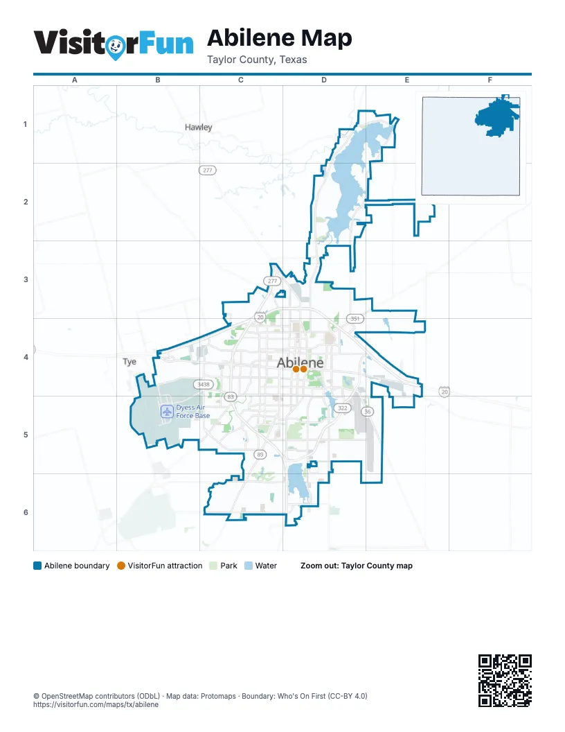
Street index of Abilene
Each street on the sheet and the grid squares it crosses.
- Winters FreewayC3, C4, C5
- Jake Roberts FreewayD4, E4, C5, D5
- Texas Vietnam Veterans Memorial HighwayC3, C5, D5, D6
- East Highway 80D4, E4
- South 1st StreetC4, D4
- Buffalo Gap RoadC5, C6
- Pine StreetC3, D3, D4
- South Treadaway BoulevardD4, D5
- West Highway 80B4, C4
- State Highway 36D4, D5, E5
- Arnold BoulevardB4, C4, B5
- Highway 351D3, E3, D4
- Dub Wright BoulevardC4, C5
- East North 10th StreetD4, E4
- US Highway 277 SouthB5, C5
- Rebecca LaneC5
- North Treadaway BoulevardD4
- East Ambler AvenueD4
- North Arnold BoulevardC4
- Liberty BoulevardD3
- Enterprise DriveD4
- Airport BoulevardD5, E5
- West Lake RoadD1, D2, D3, D4
- West Overland TrailC3, D3, B4, C4
- West Stamford StreetC3, D3, B4, C4
- South Clack StreetC4, C5, D5, D6
- Loop 322D4, D5
- East Overland TrailD3, D4, E4
- Maple StreetD4, D5, D6
- East Stamford StreetD3, D4, E4
- South Danville DriveC4, C5, D5
- Sayles BoulevardC4, C5
- Beltway SouthC6, D6
- North Clack StreetC3, C4
- North Danville DriveC3, D3, C4
- South 7th StreetC4, D4
- North 10th StreetC4, D4
- North 1st StreetC4, D4
- South 14th StreetC4, D4, C5, D5
- Grape StreetD3, D4
- Farm to Market Road 1082D1, E1, E2
- Oldham LaneD4, D5
- East South 11th StreetD4
- US Highway 83D6
- North Judge Ely BoulevardD3, D4
- Ambler AvenueC4, D4
- East Industrial BoulevardD5, E5
- South 27th StreetC5, D5
- Old Anson RoadC3, C4, D4
- South 11th StreetC4, D4
- North 6th StreetC4, D4
- Military DriveB4, C4
- Barrow StreetC4, C5
- Southwest DriveC5
- North Mockingbird LaneC4
- Industrial BoulevardC5, D5
- North 11th StreetC4, D4
- North 5th StreetC4, D4
- South Leggett DriveC4
- East South 27th StreetD5
- 5th StreetB4, B5, D5
- South Mockingbird LaneC4
- Hill StreetD5
- Expo DriveD4, D5
- South Judge Ely BoulevardD4
- East Beltway SouthD6
- Beltway NorthD3
- Chaucer DriveD4
- FM 600 SouthD1
- North Leggett DriveC4
- FM 2404C3
- East Lake RoadE1, D2, E2, D3, D4
- Hickory StreetD3, D4
- South Willis StreetC4, C5
- North 18th StreetC4, D4
- Antilley RoadC6, D6
- South 20th StreetC5, D5
- 3rd StreetB4, B5, D5
- North 12th StreetC4, D4
- Vogel StreetC4, D4
- Louisiana RoadB4, C4, B5, C5
- Catclaw DriveC5
- North Willis StreetC4
- Cedar StreetD3, D4
- FM 18D5, E5
- Corsicana AvenueC4, C5
- North 7th StreetC4, D4
- South 23rd StreetC5, D5
- Butternut StreetD4, D5
- Oak StreetD4, D5
- Shelton StreetC4
- South 32nd StreetC5, D5
- Farm-to-Market Road 3522E2
- Hardison LaneD5
- Hartford StreetC4
- Elmwood DriveC4, C5
- Chestnut StreetD4, D5
- 2nd StreetB5, D5
- Marigold StreetB4, C4
- Texas DriveB5, C5
- Washington BoulevardD4
- South Pioneer DriveC4
- Avenue DD4, B5
- 4th StreetB4, B5, D5
- Elmdale RoadE4, E5
- North Orange StreetD4
- Griffith RoadD4
- Texas AvenueC5
- Fulwiler RoadB4
- North Pioneer DriveC4
- Lytle WayD4, D5
- Campus CourtD4
- Post Oak RoadC5
- Lowden StreetC4, D4
- Ben Richey DriveD5
- East North 16th StreetD4
- North 13th StreetD4
- Shirley RoadC3, C4
- Elmdale Road NorthE4
- Musgrave BoulevardD4
- Avenue ED4, B5
- T & P LaneD4
- Cockrell DriveD4
- Bankhead HighwayB4
- Avenue AB4, B5
- Ridgemont DriveC5
- College DriveD4
- Hayter RoadC4
- Avenue BB5
- Elmwood Drive SouthC5
- Berry LaneD5
- West Summit RoadC3, D3
- East South 7th StreetD4
- East Spur 707D6
- Bumpergate RoadB4
- East North 7th StreetD4
- East South 5th StreetD4
- Navajo CircleD5
- South Pine StreetD4
- Estates DriveD4
- Hawley RoadC3, D3
- Navajo TrailD5
- South Carver DriveD4
- West South 7th StreetD4
- Clinton StreetD3, D4
- Kirby Dam RoadD5, D6
- North 14th StreetC4, D4
- South 3rd StreetB4, C4, D4
- North 3rd StreetC4, D4
- Amarillo StreetC4, C5
- Victoria StreetD3, C4, D4
- State StreetC4, D4
- South 5th StreetC4, D4
- Vine StreetD4, D5
- North 15th StreetC4, D4
- Ross AvenueC4, C5
- South 12th StreetC4, D4
- Westwood DriveC4
- Beech StreetD3, D4
- Palm StreetD4, D5
- North 9th StreetC4, D4
- Steffens StreetB4, C4
- South 8th StreetC4, D4
- South 21st StreetC5, D5
- South 6th StreetC4, D4
- Jeanette StreetD4, D5
- Dyess Air Force BaseB5
- Highland AvenueC4, C5
- Edgemont DriveC5, D5
- Grand AvenueC4, C5
- Grover Nelson ParkD4
- Cove RoadD2, E2
- South 13th StreetC4, D4
- North 2nd StreetC4, D4
- Poplar StreetD4, D5
- Kirkwood StreetC3, C4
- Merchant StreetD4
- Westview DriveC3, C4
- South 9th StreetC4, D4
- South 25th StreetC5, D5
- Marshall StreetC4, C5
- Walnut StreetD4
- Sycamore StreetD4, D5
- Memorial DriveC5, C6
- Portland AvenueC4, C5
- Meander StreetC4, D4, C5
- Russell AvenueC4
- Fairway Oaks BoulevardC5, C6
- Peach StreetD4, D5
- Newman RoadE4
- Cottonwood StreetD4
- Burger StreetC4
- Westmoreland StreetC4
- Plum StreetD3, D4
- Minter LaneC4
- South 19th StreetC5, D5
- South 2nd StreetC4, D4
- Briarwood StreetC4
- Mall of AbileneC5
- Comanche TrailD2
- Fannin StreetC4
- Graham StreetC3, C4
- Colony Hill RoadD6, E6
- Dixon RoadD1, E1, E2
- Elm StreetD4, D5
- Green StreetC4
- North 8th StreetC4, D4
- Hardwick RoadC6
- North 19th StreetC4, D4
- Autumn Sage LaneB5, C5
- Mesquite StreetD4
- Mulberry StreetD4
- Curry LaneC5
- South 10th StreetC4, D4
- Pecan StreetD4, D5
- South 15th StreetD4, C5, D5
- Chimney Rock RoadC5
- Santos StreetC4, C5
- Glendale DriveC4
- Waldrop DriveC6, D6
- Mimosa DriveC4
- Huckleberry LaneC3, D3
- Simmons AvenueD3, D4
- Abilene Municipal AirportE5
- South 4th StreetC4, D4
- Anson AvenueC3, D3
- Glenhaven DriveC4
- Wagon Wheel AvenueC6
- Lakeside DriveD4, D5
- Sunset DriveC4, C5
- Woodridge DriveC4, C5
- North 20th StreetC4, D4
- South 16th StreetC5, D5
- South 18th StreetC5, D5
- Sylvan DriveC4, C5
- Buttonwillow ParkwayC5
- North 16th StreetC4, D4
- Ivanhoe LaneC5
- County Road 311E2
- Lantana AvenueC6
- Locust StreetD4, D5
- Cypress StreetD4
- Poverty Point CreekE1
- Richland DriveC4
- University BoulevardC4, D4
- Park AvenueC4
- Cedar Crest DriveD4
- Lillius StreetC4, D4
- Fairmount StreetC4
- Waldemar StreetC4
- Saddle Creek RoadD6
- South Bowie DriveC4, C5
- Ballinger StreetC4, C5
- North 17th StreetC4, D4
- South 22nd StreetC5, D5
- Sandy StreetD4
- Presidio DriveC4
- Robertson DriveC5
- Matador StreetC4, C5
- Nugent RoadD3
- Randy AvenueC6
- Hardy StreetD3, D4
- Apache LaneD1
- Bishop RoadC5
- Meadow DriveC6
- Glenwood DriveC4, C5
- Cherry StreetD4
- Shoreline DriveD5
- Caldwell RoadD3
- Wildflower WayD6
- Rio Mesa DriveC6
- Belmont BoulevardD5
- Marsalis DriveC4
- Jennings DriveB5, C5
- Bel Air DriveC4
- Brookhollow DriveC5
- Sandefer StreetC4, D4
- Don Juan StreetC4
- Woodard StreetC4, C5
- Santa Monica DriveC5
- Ash StreetD4
- Swenson StreetD3, D4
- Yorktown DriveC4
- South San Jose DriveC4
- Lexington AvenueC4
- Kirby DamD5, D6
- Old Forrest Hill RoadC6
- Sammons StreetC4
- Morrow LaneD4
- High Meadows DriveC5
- Hair StreetD4
- Forrest Hill RoadC6
- North 4th StreetD4
- South Jefferson DriveC4
- Virginia StreetB5
- South la Salle DriveC4
- Lincoln DriveD4
- Bridge AvenueC4
- Beechwood LaneC4
- Richmond StreetC4
Things to do on the Abilene map
Places on the map
- Abilene Christian University
- Abilene Country Club South Course (Fairway)
- Abilene Field of Dreams
- Abilene Speedway
- Abilene State Supported Living Center
- Cal Young Park
- Diamondback Golf Club
- Disk golf
- Dyess Air Force Base
- Dyess Air Park
- Elmer Griffith Lake
- Elmwood Memorial Park
- Fort Phantom Hill Lake
- French Robertson Unit
- Grover Nelson Park
- Hendrick Home for Children
- Hendrick Medical Center
- J C Griffith Lake
- Kirby Lake
- Lake Kirby Park
- Lunsford Foundation Trail
- Lytle Lake
- Mall of Abilene
- Maxwell Golf Course
- Mesquite Grove Golf Course
- Oceans Behavioral Hospital Of Abilene
- R J Griffith Lake
- Red Armadillo Market Center
- Red Bud Park
- Ridgeview RV Resort
- Sea Bee Park
- Shops at Abilene
- Stonegate Self Storage
- Taylor County Expo Center
- Whistle Stop RV Resort
- Wildcat Disc Golf Course
- Woodrow Griffith Lake
- Wylie High School
- Zoo Lake Number 1
- Zoo Lake Number 2
Next to Abilene
- Hawley
- Tye
© OpenStreetMap contributors, Open Database License, openstreetmap.org/copyright · Map data: Protomaps · Boundary: Who's On First (CC-BY 4.0); Quattroshapes (CC BY 2.0)















