

Texas map
Taylor County map
About 148,813 people live here (Census Bureau, 2024 estimate). The sheet's index lists 300 streets; US Highway 277 South, Texas Vietnam Veterans Memorial Highway and West Interstate 20 cross the most grid squares. Things to do inside the boundary: Abilene, Abilene Cultural District and Buffalo Gap Historic Village.
Open the map (PDF, US Letter)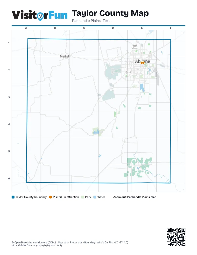
Maps inside Taylor County
1 map inside, from the street map of Taylor County down.
Street index of Taylor County
Each street on the sheet and the grid squares it crosses.
- Texas Vietnam Veterans Memorial HighwayE1, E2, E3, E4, D5, E5, C6, D6
- Winters FreewayE1, D2, E2
- Jake Roberts FreewayE2, F2
- US Highway 277 SouthD2, E2, C3, D3, B4, C4, A5, B5, A6
- East Highway 80E2, F2
- South 1st StreetB1, D2, E2
- Buffalo Gap RoadE2, D3, E3, D5
- Highway 351E1, F1
- Pine StreetE1, E2
- South Treadaway BoulevardE2
- West Highway 80D2
- State Highway 36E2, F2
- United States Highway 84E6
- Arnold BoulevardD2
- Dub Wright BoulevardD2
- East North 10th StreetE2, F2
- Rebecca LaneD2, E2
- North Treadaway BoulevardE1, E2
- East Ambler AvenueE1
- North Arnold BoulevardD1, D2
- Liberty BoulevardE1
- Garza AvenueD5
- Enterprise DriveE1
- Airport BoulevardF2
- West Interstate 20A1, B1, C1, C2, D2
- FM 1235C1, C3, D3, D4
- FM 89D3, B4, C4, D4
- FM 382D5, E5, E6
- West Overland TrailD1, E1, D2
- West Stamford StreetD1, E1, D2
- North 1st StreetB1, C1, D2, E2
- South Clack StreetD2, E2, E3
- Loop 322E2
- East Overland TrailE1, E2, F2
- South FM 707D2, D3
- South 7th StreetB2, D2, E2
- Maple StreetE2, E3
- East Stamford StreetE1, E2, F2
- South Danville DriveD2, E2
- Sayles BoulevardE2
- Beltway SouthD3, E3
- North Clack StreetE1, D2, E2
- North Danville DriveE1, E2
- North 10th StreetD2, E2
- North FM 707D1, D2
- Key LaneE3, F3
- South 14th StreetE2
- South 3rd StreetB1, B2, D2, E2
- Grape StreetE1, E2
- US Highway 83E3
- Oldham LaneE2
- East South 11th StreetE2
- North 6th StreetB1, E2
- South 8th StreetB2, E2
- Oak StreetB1, B2, E2, D4
- West Lake RoadE1
- North Judge Ely BoulevardE1, E2
- South 11th StreetB2, E2
- FM 126B1
- Ambler AvenueE1
- Vine StreetE2, D4
- East Industrial BoulevardE2, F2
- South 27th StreetE2
- Old Anson RoadE1
- Clark RoadE3
- Military DriveD2
- North 5th StreetB1, E2
- State Highway 153A6
- FM 2404D1, E1
- FM 1085A1
- Barrow StreetE2
- Graham StreetE1, E2, D5
- Southwest DriveD2, E2
- North Mockingbird LaneE1, E2
- 5th StreetD2, E2, D5, E5, E6
- Scott StreetB2, D2
- Ash StreetB1, B2, E2
- Industrial BoulevardE2
- North 11th StreetE2
- Air Base RoadD2
- Main StreetC3, D3, D4, E6
- South Leggett DriveE2
- East South 27th StreetE2
- Northwest 1st StreetA1
- East Beltway SouthE3
- South Main StreetA1, D2
- Litel StreetD4
- South Mockingbird LaneE2
- West StreetB1, D4
- Hill StreetE2
- Expo DriveE2
- South Judge Ely BoulevardE2
- Railroad AvenueD5
- Kent StreetB1
- Chaucer DriveE2
- South Cherry StreetB1, B2, E2
- Farm to Market Road 1085A1
- South Cedar StreetA1
- North Main StreetA1
- Northeast 1st StreetA1
- North East StreetD4
- North Leggett DriveE2
- North Oak StreetA1, B1
- Appleton StreetD4
- 1st SstreetD5
- North Ash StreetB1
- Spinks RoadD1, D2
- Elmdale Road NorthF1, F2
- Antilley RoadD3, E3
- Wimberly RoadC1, C2
- East Lake RoadE1
- Iberis RoadD3, E3
- Hickory StreetE1, E2
- Fulwiler RoadD1, D2
- Derstine RoadB1
- South Willis StreetE2
- North 18th StreetE1
- FM 18E2, F2
- 3rd StreetD2, E2, D4, D5
- South 20th StreetE2
- Hayter RoadD1
- Noodle Dome RoadA1, B1
- North 7th StreetB1, E2
- County Road 314D3
- North 12th StreetD2, E2
- Elmdale RoadF2
- 4th StreetD2, E2, D5, E5, E6
- Cedar StreetE1, E2, D4
- 2nd StreetD2, E2, D5, E5, E6
- Vogel StreetE1
- Bumpergate RoadD1, D2
- Louisiana RoadD2
- Catclaw DriveE2, E3
- FM 1086A5
- North Willis StreetE1, E2
- Wells LaneC1, C2
- Corsicana AvenueD2
- Shirley RoadD1
- Farm to Market Road 1082F1
- South 23rd StreetE2
- Butternut StreetE2
- Hardison LaneE2
- Shelton StreetE1, E2
- Avenue DE1, D2, E2, E6
- South 32nd StreetE2
- Hartford StreetD2, E2
- North StreetD2, D4
- Elmwood DriveE2
- Chestnut StreetE2
- Cherry StreetB1, E2, D4
- Marigold StreetD2
- Texas DriveD2
- Park Road 32D4
- Washington BoulevardE2
- South Pioneer DriveE2
- Market StreetD2
- South Access RoadD2
- Avenue AD2, E6
- North Orange StreetE1, E2
- Avenue ED2, E2, E6
- North 13th StreetB1, E2
- Avenue BD2, E6
- Griffith RoadE1, E2
- Texas AvenueD2
- North Pioneer DriveE1, E2
- Lytle WayE2
- Campus CourtE1, E2
- North Access RoadD2
- Post Oak RoadE2
- Lowden StreetE1
- Ben Richey DriveE2
- East North 16th StreetE2
- Musgrave BoulevardE1
- T & P LaneE2
- Cockrell DriveE2
- Bankhead HighwayD2
- Ridgemont DriveE2
- College DriveE1, E2
- Elmwood Drive SouthE2
- Berry LaneE2
- County Road 593A1
- West Summit RoadE1
- East South 7th StreetE2
- East Spur 707E3
- East North 7th StreetE2
- East South 5th StreetE2
- Navajo CircleE2
- South Pine StreetE2
- Estates DriveE2
- Hawley RoadE1
- Farm-to-Market Road 126B2
- Navajo TrailE2
- South Carver DriveE2
- Farm-to-Market Road 1086C6
- West South 7th StreetE2
- Farm-to-Market Road 1235C2
- North Cherry StreetB1
- County Road 134D5, E5, F5
- Potosi RoadF2, F3, F4
- County Road 154D4, E4, D5
- Braune RoadC3, D3
- County Road 162D5, E5
- County Road 131D4, E4
- County Road 207F2, C5, D5
- CR 175D5, D6
- Buckskin LaneC3, C4
- County Road 127E3, E4
- Lemons Gap RoadD5, D6
- White Mines RoadC2, C3
- County Road 301C2, C3
- County Road 142E4, E5
- County Road 194B6, C6
- County Road 672C5, C6
- County Road 353B2, C2, B3
- Old Coleman HighwayE3, E4
- County Road 159E5, F5, F6
- County Road 257D3
- Hillside RoadC3
- County Road 280C4, D4
- County Road 360B2, B3
- County Road 150D4, E4
- County Road 611A1, A2
- County Road 161D5
- Last Resort RoadC4, C5
- County Road 640C2
- Lytle Cove RoadE4, F4
- County Road 368A1, B1, A2
- County Road 365A1, A2, B2
- County Road 409B1, C1
- North 3rd StreetB1, D2, E2
- 12 Mile RoadB3
- Ohlhausen RoadD3
- County Road 401B1
- County Road 287C2
- County Road 216B5, B6
- Bell Plains RoadD3, E3, D4
- South 5th StreetB2, D2, E2
- Clinton StreetE1, E2
- County Road 503E1, F1
- County Road 186C5, C6
- County Road 205C5, D5, D6
- North 2nd StreetB1, E2
- North 14th StreetB1, D2, E2
- County Road 306C2
- County Road 379B1
- County Road 650D4, E4
- Kirby Dam RoadE2, E3
- County Road 206C5, C6
- County Road 318C3, D3
- County Road 618B3, C3, B4
- Nora Miller RoadF3, F4
- Hardwick RoadE3
- Drummond RoadC2, D2, C3
- County Road 359B3
- County Road 385B1, B2
- County Road 144E5
- County Road 563E4
- County Road 133E5
- County Road 394B2
- County Road 156E5
- Elmdale Road SouthF2
- Colony Hill RoadE3, F3
- Rode Ranch RoadD4, D5
- County Road 344A2, A3
- Mountain PassB3, B4
- Victoria StreetE1, E2
- Arrowhead Ranch RoadC4, C5
- Peppergrass Lane / County Road 333D2, D3
- County Road 298C2, C3
- Amarillo StreetE2
- Pecan StreetE2, D4
- South 6th StreetB2, D2, E2
- County Road 400B1, C1
- County Road 300C2
- County Road 145E6
- County Road 225A5
- County Road 351B3
- County Road 410C1
- County Road 138F5
- State StreetE2
- County Road 613A2
- County Road 141F4
- County Road 355B2
- County Road 309D2
- County Road 212A6, B6
- County Road 196C5, C6
- County Road 310C2, D2
- County Road 656C5
- County Road 226A5
- South 2nd StreetB1, E2
- County Road 415C1, D1
- North 15th StreetE1, E2
- Bacacita Farms RoadE3
- County Road 395B2
- Rock Ranch RoadC4
- County Road 304B2, C2
- County Road 254D5
- Ross AvenueE2
- South 12th StreetE2
- Grand AvenueE2, D3
Things to do on the Taylor County map
Places on the map
- Abilene
- Abilene Christian University
- Abilene Country Club South Course (Fairway)
- Abilene Field of Dreams
- Abilene Speedway
- Abilene State Park
- Abilene State Supported Living Center
- Buffalo Gap
- Cal Young Park
- Camp Barkeley (Abandoned)
- Camp Tonkawa
- Diamondback Golf Club
- Dyess Air Force Base
- Dyess Air Park
- Elm Valley Airport
- Elmdale Airpark
- Elmer Griffith Lake
- Elmwood Memorial Park
- Grover Nelson Park
- Hendrick Home for Children
- Hendrick Medical Center
- Impact
- J C Griffith Lake
- Kirby Lake
- Lake Abilene
- Lake Bulger
- Lake Kirby Park
- Lawn
- Lunsford Foundation Trail
- Lytle Lake
- Mall of Abilene
- Maxwell Golf Course
- Merkel
- Merkel High School
- Mesquite Grove Golf Course
- Santa Fe Lake
- Taylor County Expo Center
- Trent
- Tuscola
- Tye
© OpenStreetMap contributors, Open Database License, openstreetmap.org/copyright · Map data: Protomaps · Boundary: Who's On First (CC-BY 4.0); Quattroshapes (CC BY 2.0)















