

Texas map
Texas City map
About 57,875 people live here (Census Bureau, 2024 estimate). The sheet's index lists 300 streets; Texas Avenue, State Highway 146 North and Avenue North cross the most grid squares. Things to do inside the boundary: Busters Old Time Photos, La King's Confectionery and Nia Cultural Center.
Open the map (PDF, US Letter)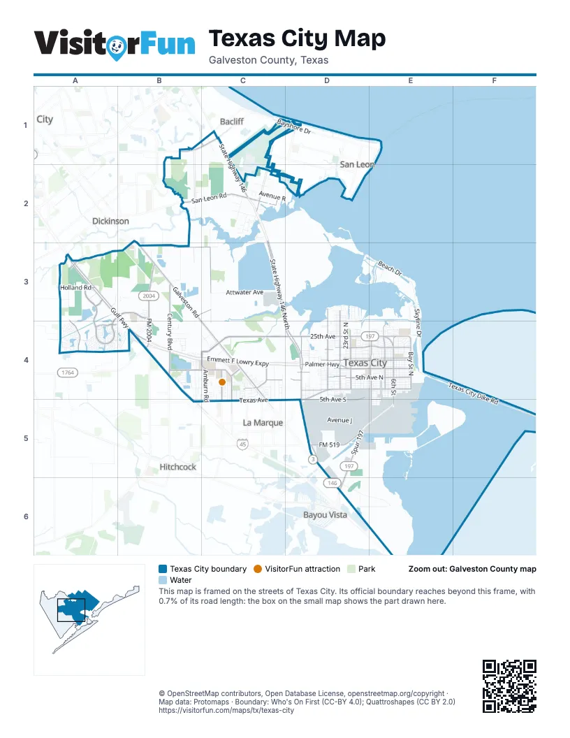
Street index of Texas City
Each street on the sheet and the grid squares it crosses.
- Emmett F Lowry ExpresswayB4, C4, D4
- Gulf FreewayA3, B3, B4
- State Highway 146 NorthC2, C3, D3, D4
- 25th AvenueC4, D4, E4
- Texas AvenueD4, E4, B5, C5, D5
- Galveston RoadB3, B4, C4
- 9th Avenue NorthD4, E4
- North Humble Camp RoadB3, C3
- FM 2004B3, B4
- San Leon RoadB2, C2
- 6th StreetE4, E5
- Spur 197D5, D6
- State Highway 146C1, C2
- Palmer HighwayD4
- 36th Street NorthD4
- Highway 146 NorthD5
- 36th Street SouthD4, D5
- Gulf Freeway Frontage RoadA3, B3, B4
- North Amburn RoadC4
- 5th Avenue SouthD4, D5, E5
- FM 519D5
- 29th StreetC1, C2
- 16th StreetB1, C1
- Avenue SC2
- FM 646 EastB1
- West Bayshore DriveC1
- East Bayshore DriveD1
- Grand AvenueC1
- West Bay Shore DriveC1
- Lago Mar BoulevardA3, B3, A4
- Century BoulevardB3, B4
- 5th Avenue NorthC4, D4, E4
- 19th Avenue NorthD4, E4
- 13th Avenue NorthD4, E4
- 29th Street NorthD3, D4
- Hughes RoadA3, A4
- 25th Street NorthD3, D4
- 14th Avenue NorthD4, E4
- 9th Street NorthE4
- Monticello DriveB4, C4
- Central Park BoulevardB3
- 21st Street NorthD3, D4
- 14th Street NorthE4
- Bay Street NorthE4
- Holland RoadA3
- North Oak StreetC4
- Crystal View BoulevardA4
- 14th Street SouthE4, E5
- 25th Avenue NorthC4, E4
- North Vauthier RoadC4
- Fashion WayA3
- Willow StreetC4
- Oak StreetC4, C5
- North Westward StreetC4
- 27th StreetD1, C2
- Phillips StreetC4
- Mentor DriveC4
- Memorial DriveC4
- South Vauthier RoadC4, C5
- South Westward StreetC4, C5
- South Amburn RoadC4, C5
- Madrid LaneB1, C1
- Westward AvenueC5
- Texas City Dike RoadE4, F4, F5
- Campbell Bayou RoadD6, E6
- 2nd Avenue NorthD4, E4
- 1st Avenue NorthD4, E4
- 3rd Avenue NorthD4, E4
- Skyline DriveE3, B4, E4
- 16th Avenue NorthD4, E4
- Beach DriveD3, E3
- 4th Avenue NorthD4, E4
- 23rd Street NorthD3, D4
- 8th Avenue NorthD4, E4
- Avenue NorthC1, C2, D5, E5
- 2nd Avenue SouthD4, E4
- Attwater AvenueC3
- 17th Avenue NorthD4, E4
- 18th Avenue NorthD4, E4
- 7th Avenue NorthD4, E4
- 20th Avenue NorthD4, E4
- 22nd Avenue NorthD4, E4
- 6th Avenue NorthD4, E4
- 19th Street NorthD3, D4
- 15th Avenue NorthD4, E4
- Avenue JC1, D5, E5
- 34th Street NorthD4
- 4th Street NorthE4
- Grant StreetD5
- 23rd Avenue NorthD4, E4
- 21st Avenue NorthD4, E4
- 11th Street NorthE4
- Ave FD5, E5
- 28th Avenue NorthD4, E4
- Ave KD5
- 15th Street NorthD4
- 12th Avenue NorthD4, E4
- 8th Street NorthE4
- 13th Street NorthE4
- 4th Avenue SouthD4, E4
- Starboard Reach DriveA3, A4
- 22nd Street NorthD3, D4
- Ave GD5
- Avenue RC2, D2
- 7th Street NorthE4
- 2nd Street NorthE4
- Wetzel DriveB3
- 3rd Avenue SouthD4, E4
- 26th Street NorthD3, D4
- 24th Avenue NorthD4, E4
- 10th Street NorthE4
- 10th Avenue NorthD4, E4
- Lago CrossingA4
- 1st Street NorthE4
- Bay StreetE3, E4
- Avenue DC1, D1, D5, E5
- Martin Luther King BoulevardE4
- Lago Costa DriveA4
- East 2nd StreetD5
- Santo Park RoadA3
- 27th Avenue NorthD4, E4
- 1st Avenue SouthD4
- 31st Street NorthD4
- Carver AvenueC4
- 11th Avenue NorthD4, E4
- 16th Street NorthD4
- 26th Avenue NorthD4, E4
- 32nd Avenue NorthB4, D4
- 3rd Street NorthE4
- 30th Avenue NorthB4, D4
- West 6th StreetD5
- 20th Street NorthD3, D4
- 34th Avenue NorthD4
- Woodrow StreetC4
- 5th Street NorthE4
- 17th Street NorthD3, D4
- 36th Avenue NorthD3
- Anderson StreetC4
- 12th Street NorthE4
- Humble Camp RoadB3
- Grand Cay BoulevardE3
- Bowerman DriveC2
- North Noble RoadB4
- Magnolia AvenueD4
- 31st Avenue NorthB4, D4
- San Leon DriveC2
- 29th Avenue NorthD4, E4
- North Pine RoadC4
- 24th Street NorthD3, D4
- 6th Street NorthE4
- Ave CD5
- Avenue UC2
- East 1st StreetD5
- Outlets BoulevardA3
- Beacon Point BoulevardA3
- Main StreetD5
- Lane RoadC4
- Ave MD5
- Avenue HC1, D5, E5
- Farm-to-Market Road 1764C4
- Paula LaneC2, C3
- 33rd Avenue NorthD4
- Tarpey RoadB4
- West 2nd StreetD5
- Ruby DriveC4
- Park AvenueC4
- Avenue TC2
- West 1st StreetD5
- Avenue BC1, D5
- Humble Camp Road SouthC3
- 18th Street NorthD3, D4
- San Jacinto AvenueE4
- 28th Street NorthD4
- Hillman DriveC2
- 12th Street SouthE4, E5
- 13th Street SouthE4, E5
- West 5th StreetD5
- West Quaker DriveD3
- Brigantine Cay BoulevardE3
- Avenue QC2, D2
- Benoist DriveB3
- Rice RoadA3
- West 3rd StreetD5
- Vicksburg StreetC1
- Paseo LoboB4
- Barracuda DriveB4
- North Orchid DriveC4
- Sea Breeze DriveA4
- Regatta LaneB4
- 33rd Street NorthD4
- Strom RoadB2
- Amberjack DriveB4
- 25th StreetD2
- Mainland Center DriveC4
- Buttonwood DriveB4
- Lago Front DriveA4
- Jones RoadB4, C4
- East 9th StreetE5
- 25th Street SouthD4, D5
- Wayside DriveD4, E4
- South Noble RoadB4
- Virginia Point DriveE6
- Royal Oak DriveC4
- West 4th StreetD5
- Mainland DriveE4
- Vicksburg AvenueB4
- 21st Street SouthD4, D5
- 27th Street NorthD4
- Murano DriveA4, B4
- Wincrest RoadB2
- Melody LaneA3
- Redfish DriveB4
- Bayrose DriveA4
- Shiloh DriveB4
- Gales Point DriveA4
- 35th Avenue NorthD3
- 37th Avenue NorthD3
- 38th Avenue NorthD3
- Ocean Breeze LaneA4
- Ave ID5, E5
- Freeboard DriveA4
- Ecret DriveB3
- Benson RoadA3
- East 4th StreetD5
- Allen Cay BoulevardE3
- South Willow StreetC4, C5
- Avenue WestC2
- Robertson StreetC4
- Diamond Reef LaneA4
- Silver Egret LaneA4
- North Heritage Oaks DriveC4
- Golden Oak DriveC4
- Glacier AvenueB4
- 20th Street SouthD4, D5
- Blue Bonnet DriveB4
- South Pine RoadC4, C5
- North Natchez DriveB4
- Orange AvenueD4
- 29 North AvenueE4
- Arbor Edge CrossingA4
- Secret Lagoon LaneA4
- South Pecan DriveC4
- Seneca Lake DriveA4
- South Orchid DriveC4, C5
- 10th Street SouthE4, E5
- Hemphill StreetC4
- South Algeria StreetC4
- South Cobb StreetC4
- South Rose StreetC4
- South Washington StreetC4, C5
- South Fulton StreetC4, C5
- South Texas StreetC4, C5
- 31st Street SouthD4, D5
- Groveshire DriveB4
- 27th Street SouthD4, D5
- West Pilgrim Estates DriveD3
- East 8th StreetD5
- Cherry AvenueD4
- North Texas StreetC4
- Plantation DriveB4
- Danforth Memorial DriveD4
- 29th Street SouthD4, D5
- 35th Street SouthD4, D5
- Seagrass Knoll LaneA4
- Depalermo RoadB3
- North Pecan DriveC4
- 34th Street SouthD4, D5
- David StreetC2
- Luce Del Porto WayC4
- Gate 42D4, D5
- 32nd Street NorthD4
- North Vionett LaneC4
- North Willow StreetC4
- Park RoadD1
- 11th Street SouthE4, E5
- Flora Manor DriveA4
- Palm AvenueD4
- Quartz LaneC4
- Seacrest LaneB4
- South Bell DriveC4, C5
- Table Rock DriveA4
- Highborne Cay CourtE3
- 12th 1/2 Street NorthE4
- Winter Sand DriveA4
- Fawnwood DriveB3, B4
- Emerald LaneC4
- Trawler PlaceB4
- Avenue EC1, D5, E5
- South West RoadB4, B5
- 11th 1/2 Street NorthE4
- Robinson BoulevardD4
- 7th Street SouthE4
- 8th Street SouthE4
- 9th Street SouthE4
- Humble RoadC3
- North Fulton StreetC4
- Avenue PC2
- Appomattox DriveB4
- Bonito DriveB4
- Cumberland DriveA4, B4
Things to do on the Texas City map
Places on the map
- 6th Street Community Plaza
- Advance Auto Parts
- ALDI
- Americas Best Value Inn
- Amoco Park
- Austinia Airport
- Bay Street Park
- Bayshore Park
- Best Western
- Beyond Burger
- Blocker Middle School
- Booker T's Gym Arena
- Braslau Park
- Bremond Park
- Buc-ee's
- Calvin Vincent Early Childhood Center
- Candlewood Suites
- Carnes Funeral Home
- Carole S. Young Medical Facility
- Carver Park
- Galveston County Industrial Reservoir
- Goddard Park
- Hughes Road Elementary School
- Lago Dorado
- Lago Mar Lagoon
- Lago Mar Lake
- LagoonFest
- Laseair Airport
- Levi Fry Intermediate School
- Mainland City Centre
- Mainland Medical Center
- Mall of the Mainland
- Moses Lake
- Mount Olivet Cemetery
- Northside Elementary School
- Red Fish Island
- Simms Elementary School
- Tanger Outlets - Galveston / Houston
- Texas City Bay
- Texas City High School
Next to Texas City
- Bacliff
- Bayou Vista
- Dickinson map
- Hitchcock
- La Marque map
- San Leon
© OpenStreetMap contributors, Open Database License, openstreetmap.org/copyright · Map data: Protomaps · Boundary: Who's On First (CC-BY 4.0); Quattroshapes (CC BY 2.0)















