

Utah road map
Utah highway map
5 Interstate routes run about 955 miles in Utah, each on a sheet of its own. The sheet's index lists 33 highways; I-15, US 89 and US 191 cross the most grid squares. Towns on it: Salt Lake City, Provo and St. George.
Open the map (PDF, US Letter)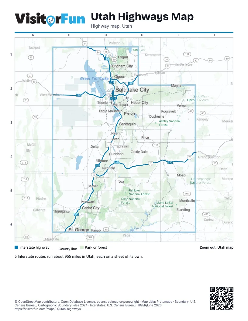
Road maps of Utah
13 road maps: each Interstate and byway on a sheet of its own.
- I-15 in Utah
- I-70 in Utah
- I-80 in Utah
- I-84 in Utah
- I-215 in Utah
- Dinosaur Diamond Prehistoric Highway
- Flaming Gorge-Uintas Scenic Byway
- Logan Canyon Scenic Byway
- Scenic Byway 12
- Scenic Byway 143 - Utah's Patchwork Parkway
- The Energy Loop: Huntington and Eccles Canyons Scenic Byways
- Trail of the Ancients
- Zion Scenic Byway
Highway index of Utah
Each highway on the sheet and the grid squares it crosses.
- I-15B5, B6, C1, C2, C3, C4, C5
- I-70C4, C5, D4, E4
- I-80B2, C2, D2
- I-84B1, C1, C2, D2
- I-215C2
- US 6C3, D3, D4, E4
- US 40D2, D3, E2, E3
- US 50C4, D4, E4
- US 89C1, C2, C3, C4, C5, C6, D3
- US 89AC6
- US 91C1
- US 189C3, D2, D3
- US 191D3, D4, E2, E3, E4, E5
- US 491E5
- SR 7B6
- SR 9B6
- SR 16D1
- SR 20C5
- SR 30C1, D1
- SR 36C2, C3
- SR 52C3
- SR 59B6
- SR 67C2
- SR 73C3
- SR 85C2, C3
- SR 145C3
- SR 154C2
- SR 177C2
- SR 194C3
- SR 201C2
- SR 224D2
- SR 248D2
- AZ 389B6
Places on the map
- Beaver
- Blanding
- Brigham City
- Castle Dale
- Cedar City
- Delta
- Duchesne
- Eagle Mountain
- Enterprise
- Ephraim
- Fillmore
- Gunnison
- Heber City
- Herriman
- Kanab
- Levan
- Loa
- Logan
- Manila
- Moab
- Monticello
- Nephi
- Ogden
- Parowan
- Price
- Provo
- Richfield
- Roosevelt
- Salt Lake City
- Santaquin
- St. George
- Tooele
- Vernal
© OpenStreetMap contributors, Open Database License, openstreetmap.org/copyright · Map data: Protomaps · Boundary: U.S. Census Bureau, Cartographic Boundary Files 2024 · Interstates: U.S. Census Bureau, TIGER/Line 2026















