

Utah map
Utah map
Things to do inside the boundary: Adrift Adventures, Adventure ORX and Alf Engen Ski Museum. Also on it: Ashley National Forest, Bear River Migratory Bird Refuge and Beaver Dam Wash National Conservation Area. Just past the edge: Durango, Ely and Farmington.
Open the map (PDF, US Letter)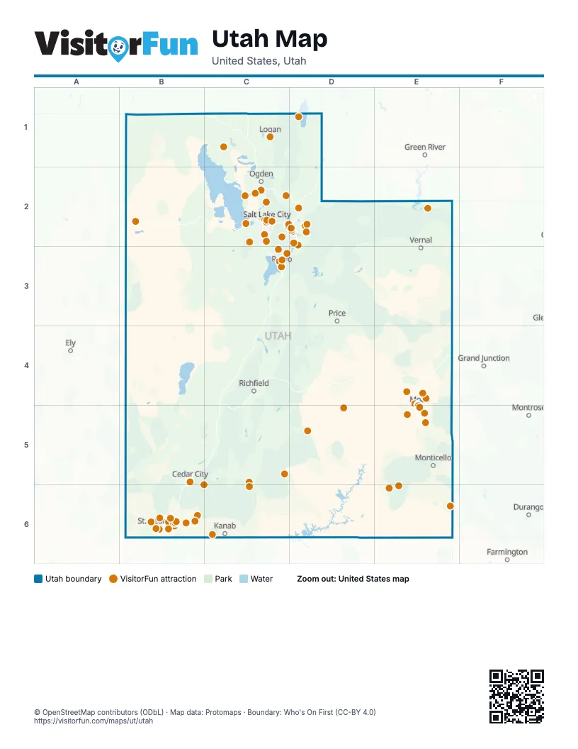
Maps inside Utah
4 maps inside, from the street map of Utah down.
Things to do on the Utah map
- Adrift Adventures
- Adventure ORX
- Alf Engen Ski Museum
- Alta Ski Area
- Angels Landing
- Antelope Island State Park
- Arches National Park
- Arts to Zion Art and Studio Tour
- Ascent Air Charter
- ATV Offroad Adventures
- Backcountry Snowmobiling
- Bear Lake State Park
- Bears Ears National Monument
- Best Western Plus Ruby's Inn
- Bingham Canyon Mine
- Black Tie Ski Rentals of Park City
- Blu Pig
- Bonneville Salt Flats
- Bryce Canyon National Park
- Cache Valley
- Canyonlands Ballooning
- Canyonlands by Night and Day
- Canyonlands Jeep Adventures
- Capitol Reef National Park
- Cedar Breaks National Monument
- Cedar City & Brian Head
- Chile Pepper Bike Shop
- City Sights Tours
- Clark Planetarium
- Coral Pink Sand Dunes State Park
- Coyote Land Tours
- Dan Mick's Guided Jeep Tours
- Dead Horse Point State Park
- Deer Valley Resort
- Delicate Arch
- Delta Center
- Desert Highlights
- Desert Sun Ceramics
- Dig Paddlesports
- Dreamwalk Park
- E-Bike Moab
- Eccles Theater
- Explore Utah Valley
- Fat Daddy's Pizzeria
- Fiesta Fun Center
- Flaming Gorge National Recreation Area
- Gardner Village
- Gearheads Outdoor Store
- Gilgal Sculpture Garden
- Goblin Valley State Park
- Golden Spike National Historical Park
- Grand Staircase-Escalante National Monument
- Great Salt Lake State Park
- Great Saltair
- Greater Zion
- Greater Zion E-Bikes
- Heber Valley
- Heber Valley Railroad
- High Country Adventure
- High Point Hummer & ATV
- Hill Aerospace Museum
- Hole N" The Rock
- Hovenweep National Monument
- Junction Commons
- Lagoon
- Loveland Living Planet Aquarium
- McQuarrie Memorial Museum
- Moab
- Moab Adventure Center
- Moab Giants
- Moab Jett
- Moab Rock Shop
- Moab Tour Company
- Moab Tourism Center
- Natural Bridges National Monument
- Natural History Museum of Utah
- North Forty Escapes
- Paddle Moab
- Park City Day Tours
- Park City Ghost Tours
- Park City Mountain
- Park City Museum
- Park City Peaks Snowmobiling
- Park City Rafting
- Raven's Rim Adventure Tours
- Red Butte Garden
- Red Iguana
- Red Rock Humvee Tours
- Red Rock Shuttle
- Red Rock SxS Tours
- Redtail Air Adventures
- Rope Swing Moab
- Salt Lake Temple
- Sand Hollow Rentals
- Sheri Griffith River Expeditions
- Silver Reef Museum
- Skydive Moab
- Snowbird Ski & Summer Resort
- SoTah Adventures
- Southern Utah Adventure Center
- Southwest Adventure Tours
- Spanish Valley Vineyard & Winery
- St. George Dinosaur Discovery Site at Johnson Farm
- Stargazing Moab
- Sundance Mountain Resort
- Temple Square
- The Market at Park City
- The Rush Funplex
- This Is The Place Heritage Park
- Timpanogos Cave National Monument
- Tuacahn Center for the Arts
- Uinta Adventures
- Uinta Recreation
- Utah Adventure Center
- Utah Olympic Park
- Utah Ski & Golf
- Utah State Capitol
- Utah's Hogle Zoo
- UTV Adventure Tours
- Wasatch Excursions
- Washington County Museums
- Wild West Voyages
- Zion Balloons
- Zion Canyon Hot Springs
- Zion Helicopters
- Zion Jeep Tours
- Zion National Park
- Zion Vineyards
Places on the map
- Antelope Island State Park
- Arches National Park
- Ashley National Forest
- Bear Lake State Park
- Bear River Migratory Bird Refuge
- Bears Ears National Monument
- Beaver Dam Wash National Conservation Area
- Bryce Canyon National Park
- Canyonlands National Park
- Capitol Reef National Park
- Cedar Mountain Wilderness
- Dark Canyon ISA Complex
- Dark Canyon Wilderness
- Desolation Canyon Wilderness
- Dixie National Forest
- Dugway Proving Ground (East)
- Dugway Proving Ground (West)
- Fishlake National Forest
- Glen Canyon National Recreation Area
- Grand Gulch Instant Study Area Complex
- Grand Staircase–Escalante National Monument
- High Uintas Wilderness
- Hovenweep National Monument
- Island In The Sky District
- King Top Wilderness Study Area
- Labyrinth Canyon Wilderness
- Little Sahara Recreation Area
- Manti-La Sal National Forest
- Maze District
- Mexican Mountain Wilderness
- Muddy Creek Wilderness
- Needles District
- Orange Cliffs Unit of Glen Canyon
- Raft River Mountains
- Red Cliffs National Conservation Area
- San Rafael Reef Wilderness
- San Rafael Swell Recreation Area
- Sid's Mountain Wilderness
- Uinta-Wasatch-Cache National Forest
- Utah Test and Training Range (North Area)
Next to Utah
- Durango
- Ely
- Farmington
- Grand Junction
- Green River
- Montrose
© OpenStreetMap contributors (ODbL) · Map data: Protomaps · Boundary: Who's On First (CC-BY 4.0)