

Virginia map
Alexandria map
About 159,102 people live here (Census Bureau, 2024 estimate). The sheet's index lists 300 streets; Duke Street, Eisenhower Avenue and Henry G. Shirley Memorial Highway cross the most grid squares. Things to do inside the boundary: Alexandria History Museum at The Lyceum, Freedom House Museum and George Washington Masonic National Memorial.
Open the map (PDF, US Letter)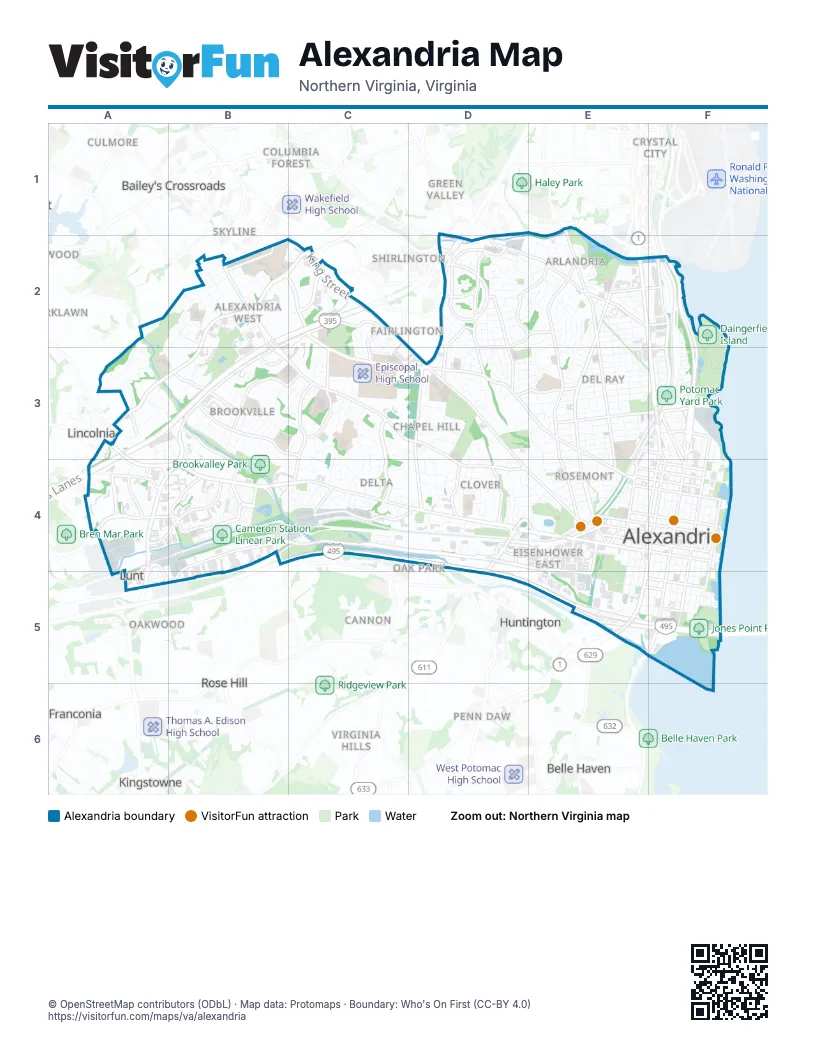
Street index of Alexandria
Each street on the sheet and the grid squares it crosses.
- Henry G. Shirley Memorial HighwayB2, C2, D2, A3, B3, A4
- Capital Beltway (Thru)C4, D4, D5, E5, F5
- Capital Beltway (Local)C4, D4, D5, E5, F5
- George Washington Memorial ParkwayF2, F3
- 395 Express LanesB2, C2, D2, A3, B3, A4
- Capital BeltwayB4, C4
- Duke StreetA3, A4, B4, C4, D4, E4, F4
- King StreetC2, D3, D4, E4, F4
- Richmond HighwayE2, F2, F3, E5
- North Van Dorn StreetB2, C2, B3, C3, B4
- South Van Dorn StreetA4, B4, A5
- South Patrick StreetE4, F4, E5
- South Washington StreetF4, E5, F5
- North Henry StreetF3, E4, F4
- Telegraph RoadD4, D5
- North Washington StreetF3, F4
- North Patrick StreetF3, F4
- South Henry StreetE4, E5
- Little River TurnpikeA3
- Washington StreetE5
- Eisenhower AvenueB4, C4, D4, E4, A5, B5, E5
- West Braddock RoadB2, C2, C3, D3, E3
- North Beauregard StreetB2, C2, A3, B3
- Seminary RoadB2, B3, C3, D3
- Mount Vernon AvenueE1, E2, E3, E4
- Russell RoadE2, E3, E4
- North Quaker LaneD2, D3, D4
- Mill RoadD4, E4, E5
- South Pickett StreetA4, B4
- North Howard StreetB3, C3, B4
- Edsall RoadA4, B4
- West Glebe RoadD2, E2
- Janney's LaneD3, D4
- North Royal StreetF3, F4
- South Royal StreetF4, F5
- Franklin StreetE5, F5
- Pendleton StreetE4, F4
- East Braddock RoadE3, E4
- Gibbon StreetE5, F5
- Slaters LaneF3
- East Glebe RoadE2, F2
- North West StreetE4
- Holland LaneE4, E5
- Eisenhower Avenue ConnectorB4
- Callahan DriveE4
- Shirlington CircleD2
- South West StreetE4
- Stovall StreetD4
- Menokin DriveC2
- South Four Mile Run DriveD1, D2
- South Shirlington RoadD1, D2
- Pershing AvenueD4
- South Walter Reed DriveC2
- Shirlington RoadD1
- South Arlington Mill DriveD2
- Commonwealth AvenueE2, E3, E4
- Potomac AvenueF2, F3
- Cameron Station BoulevardB4
- Taney AvenueB3, C3, C4
- Fort Williams ParkwayC3, C4
- Valley DriveD2, D3
- Holmes Run ParkwayA2, B3, B4
- Cameron Mills RoadD2, D3
- Main Line BoulevardF2, E3, F3
- Cameron StreetE4, F4
- Prince StreetE4, F4
- North Pegram StreetB3, C3
- Wheeler AvenueC4, D4
- Brenman Park DriveB4
- Martha Custis DriveD2
- Powhatan StreetF3, F4
- Old Dominion BoulevardD2, E2
- North Pickett StreetC2, B3, C3, B4
- North Jordan StreetC3, C4
- North Hampton DriveC2
- South Columbus StreetC2, F4, F5
- Dawes AvenueB2
- Stevenson AvenueA4
- West Taylor Run ParkwayD3, D4
- Queen StreetE4, F4
- Gunston RoadD2
- Madison StreetE4, F4
- Yoakum ParkwayA4
- North Columbus StreetF3, F4
- East Monroe AvenueE3, F3
- South Lee StreetF4, F5
- East Windsor AvenueE3, F3
- First StreetE3, F3, E4, F4
- Wythe StreetE4, F4
- Kenwood AvenueD2, D3
- Kenmore AvenueB2, C2, B3, C3
- Montgomery StreetF4
- Sanger AvenueA3, B3
- South Union StreetF4, F5
- East Reed AvenueE2, F2
- West Windsor AvenueD3, E3
- South Whiting StreetA4
- Richenbacher AvenueB3
- Yale DriveD4
- Green StreetE5, F5
- South Reynolds StreetB4
- North Earley StreetC2, C3, C4
- Dulany StreetE4
- Bashford LaneF3
- Monticello BoulevardD2, E2
- Swann AvenueF2, E3, F3
- East Abingdon DriveF3
- Jamieson AvenueE4
- North Union StreetF4
- Diagonal RoadE4
- Summit AvenueD2, D3
- West Abingdon DriveF3
- Somerville StreetB4
- North Lee StreetF4
- Preston RoadD2
- South Gordon StreetC4
- Chalfonte DriveD2
- South 28th StreetC2
- West Monroe AvenueE3
- Quantrell AvenueA3
- Daingerfield RoadE4
- North Dearing StreetC2, C3
- Fern StreetD3
- South Peyton StreetE4
- Metro RoadA4, A5
- South Walker StreetA4
- 33rd Street SouthD2
- Duke Street Service RoadC4, D4
- North Chambliss StreetA2, B2, A3
- Dewitt AvenueE2, E3
- East Custis AvenueE3, F3
- East Howell AvenueE3, F3
- North Pitt StreetF3, F4
- Oronoco StreetE4, F4
- Princess StreetE4, F4
- Crestwood DriveD2
- North Fairfax StreetF3, F4
- Fillmore AvenueB2
- North Fayette StreetF3, E4, F4
- North Morgan StreetA3, B3
- Wilkes StreetE4, F4, F5
- Leslie AvenueE3
- East Taylor Run ParkwayD3, D4
- Beverley DriveD2, E2
- South Alfred StreetF4, E5, F5
- North Saint Asaph StreetF3, F4
- North Alfred StreetF3, F4
- South Saint Asaph StreetF4, F5
- Potomac Greens DriveF2, F3
- South Fairfax StreetF4, F5
- South Payne StreetE4, E5
- East Bellefonte AvenueE3, F3
- Trinity DriveC4, D4
- Dartmouth RoadD4
- Saint Stephens RoadC3
- Tennessee AvenueD2, E2
- Marina DriveF2, F3
- South Pitt StreetF4, F5
- North Armistead StreetA3
- North Paxton StreetB3, B4
- Raleigh AvenueC3, B4, C4
- Mark Center DriveB2, B3
- Jefferson StreetE5, F5
- Wolfe StreetF4, F5
- South Fayette StreetE4, E5
- Polk AvenueB3
- North Overlook DriveD2, E2
- Virginia AvenueD3, E3
- Stadium DriveC3
- Fort Worth AvenueC3, C4
- Chinaquapin DriveD3
- Reading AvenueB2, B3
- East Glendale AvenueE3
- East Alexandria AvenueE3
- East Nelson AvenueE3
- Fontaine StreetD3, E3
- North Payne StreetE3, F3, E4
- North Ripley StreetB3, B4
- West Timber Branch ParkwayD3
- East Timber Branch ParkwayD3, E3
- Randolph AvenueE2, E3
- East Luray AvenueE3
- Woodland TerraceD3, E3
- Donovan DriveB4
- Holly StreetE2
- John Carlyle StreetE4, E5
- Cambridge RoadD4
- Rayburn AvenueB2
- Potomac Greens Service DriveF2, F3
- East Del Ray AvenueE3
- Dogwood DriveD2, D3
- East Mason AvenueE3
- Hume AvenueE2
- East Raymond AvenueE2, F2
- North Latham StreetB3, B4
- Ridge Road DriveD2, D3
- West Rosemont AvenueE4
- Normandy Hill DriveC4
- Farm RoadD2, D3
- Key DriveD3
- North Rosser StreetB2
- Allison StreetD2
- Hancock AvenueE3
- Roberts LaneD4, E4
- Carpenter RoadF2, F3
- Clifford AvenueE2
- Farrington AvenueA5
- Wayne StreetE3, E4
- Vermont AvenueC4
- Business Center DriveD4
- Davis AvenueD2, D3
- Skyhill RoadD4
- Upland PlaceD4, E4
- West Alexandria AvenueE3
- Oakcrest DriveD2, D3
- Executive AvenueE2
- Mosby StreetE2
- Canterbury SquareB3, B4
- Francis Hammond ParkwayD3, D4
- Duncan AvenueE3
- Vassar RoadD4
- Montrose AvenueE2
- Ramsey StreetE3, E4
- West Masonic View AvenueE4
- Echols AvenueB2
- Central AvenueD2, D3
- Luna Park DriveE2
- Knapp PlaceB4
- Scroggins RoadD3
- Four Mile RoadE2
- Saxony SquareA3
- Deanery DriveC3
- Mark Center AvenueB2
- West Glendale AvenueE3
- Little StreetE3, E4
- Circle Hill RoadD2, E2
- West Mount Ida AvenueE2, E3
- Trotter RoadC3, D3
- Second StreetF3
- Colonel Ellis AvenueC3
- North View TerraceE4
- Jones Point DriveF5
- University DriveF2
- Colvin StreetD4
- Landover StreetE2
- Rynex DriveA3
- East Oxford AvenueE3
- North Gordon StreetC3, C4
- Main DriveC3, D3
- Sheffield CourtB3
- North Stevens StreetB2
- Wyndham CircleC2
- West Myrtle StreetE4
- East Mount Ida AvenueE3, F3
- Quaker Hill DriveD4
- Mansion DriveE2, E3
- Moncure DriveD4
- Sycamore StreetE2, E3
- West Walnut StreetE4
- Thomsen LaneC3
- Hickory StreetE2, E3
- Clyde AvenueE3
- Ballenger AvenueE4
- East Spring StreetE3
- South Overlook DriveD2
- Lloyds LaneD3, E3
- North Owen StreetB3
- Bayliss DriveD3
- South Dove StreetD4, E4
- East Oak StreetE4
- Brawner PlaceB4
- North Gaillard StreetC3
- East Walnut StreetE4
- Kennedy StreetE2
- Alabama AvenueE2
- Kingston AvenueD3
- Braddock PlaceD3, E3, E4, F4
- Orchard StreetE3
- Highview LaneB2
- Wesmond DriveE2
- Enderby DriveD2
- Hunting Creek DriveF3
- Newton StreetE3
- North Ashton StreetA3
- Witter StreetD4
- Gretna Green CourtB4
- Summers DriveE3
- Keller AvenueC3
- North Pelham StreetB3
- Argyle DriveE2
- Commerce StreetE4
- East Maple StreetE4
- Ellicott StreetC2, C3
- Crescent DriveD2
- La Verne AvenueE2
- Ashby StreetE2
- Ingle PlaceC4
- Crown View DriveD4
- Halcyon DriveE2
- Portner RoadF3
Things to do on the Alexandria map
Places on the map
- Alexandria Campus Library
- Alexandria City High School
- Alexandria Commons
- Alexandria Post Office
- Angel Park
- Ben Brenman Park
- Bradlee Shopping Center
- Brookvalley Park
- Cameron Run
- Cameron Station Linear Park
- Charles Barrett
- Cora Kelly
- Daingerfield Island
- Dora Kelley Nature Park
- Douglas MacArthur
- Episcopal High School
- Forest Park
- Four Mile Run Park
- George Mason
- George Washington Masonic National Memorial
- Inova Alexandria Hospital
- James K. Polk
- Jefferson Houston
- John Adams
- Jones Point Park
- Lyles-Crouch
- Matthew Maury
- Mount Jefferson Park
- Mount Vernon
- Patrick Henry
- Potomac Yard
- Potomac Yard Center
- Potomac Yard Park
- Samuel Tucker
- Stonegate Scenic Easement
- Virginia House District 45
- Washington Sailing Marina
- William Ramsay
- Winkler Botanical Preserve
- WMATA Alexandria Yard
Next to Alexandria
- Addison Heights
- Arlington Mill
- Aurora Hills
- Bailey's Crossroads
- Belle Haven
- Belle View
- Brookland Estates
- Burgundy Village
- Bush Hill Woods
- Cameron Villa Farms
- Cannon
- Claremont
- Clermont Woods
- Columbia Forest
- Courtland Park
- Crystal City
- Culmore
- Douglas Park
- Dowden Terrace
- Fair Haven
- Fairlington
- Fort Barnard Heights
- Franconia
- Glen Forest
- Governors Grove
- Green Valley
- Guilford
- Huntington
- Jefferson Manor
- Kathmoor
- Kingstowne
- Lakewood
- Lincolnia
- Lincolnia Heights
- Lincolnia Park
- Long Branch Creek
- Maple Grove Estates
- Oak Park
- Oakcrest
- Oakwood
- Parklawn
- Penn Daw
- Penn Daw Village
- Ridgeview
- Rose Hill
- Rose Hill Farms
- Shirlington
- Silver Springs
- Skyline
- Spring Bank
- Sunset Manor
- Virginia Heights
- Virginia Hills
- Walhaven
- Wilton Woods
- Winslow Hills
© OpenStreetMap contributors, Open Database License, openstreetmap.org/copyright · Map data: Protomaps · Boundary: Who's On First (CC-BY 4.0)















