

Vermont map
Washington County map
About 59,844 people live here (Census Bureau, 2024 estimate). The sheet's index lists 300 streets; U.S. Route 2, Main Street and West Hill Road cross the most grid squares. Things to do inside the boundary: Ben & Jerry's Factory, Hubbard Park and Molly's Falls Pond State Park.
Open the map (PDF, US Letter)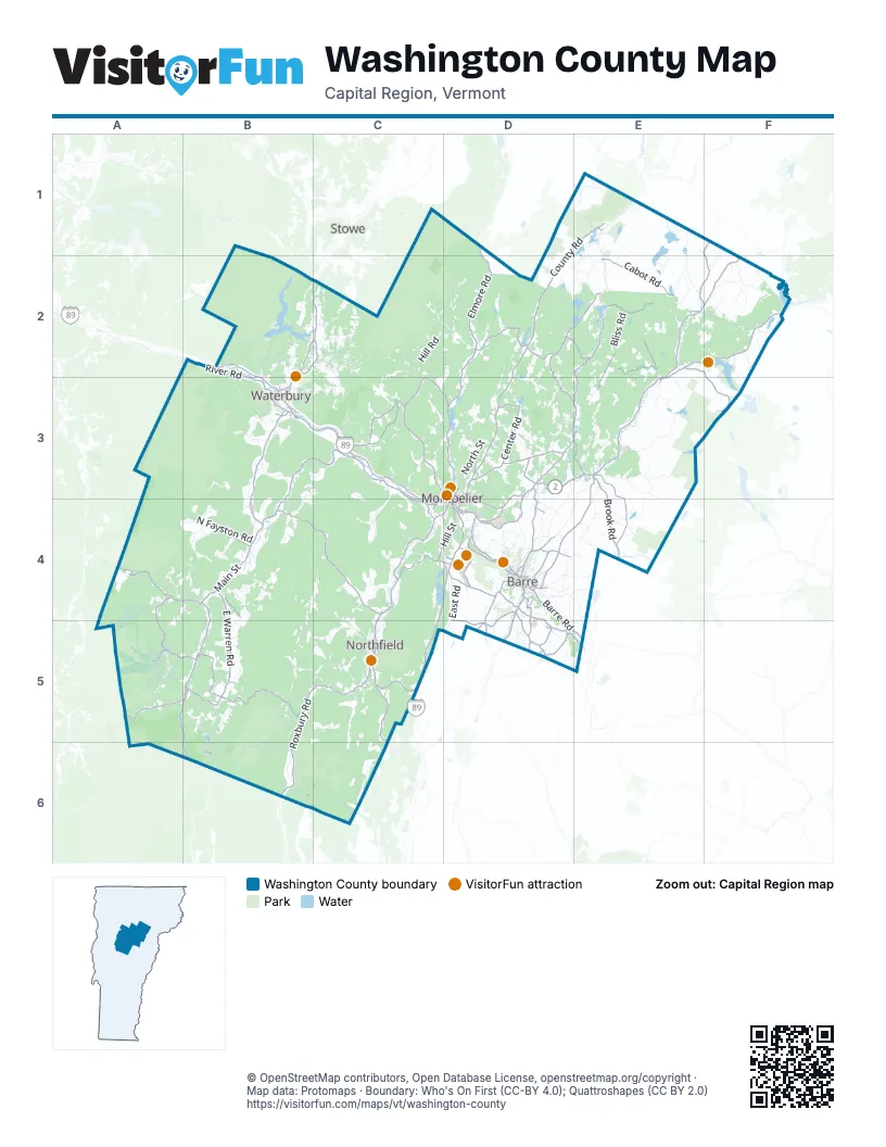
Street index of Washington County
Each street on the sheet and the grid squares it crosses.
- U.S. Route 2B2, E2, F2, B3, C3, D3, E3, D4
- Vermont Route 100B3, B4, A5, B5, A6, B6
- Main StreetE2, F2, B3, D3, E3, B4, D4, B5
- Center RoadC3, D3
- Vermont Route 62D4
- Vermont Route 14E2, D3, E3, D5
- Waterbury Stowe RoadB2, C2, B3
- Vermont Route 63D4, D5
- North Main StreetB3, D4, C5
- Vermont Route 14 NorthD3, E3
- South Main StreetB3, D4, C5
- East Barre RoadD4, D5, E5
- Vermont Route 14 SouthD3, D4
- South Barre RoadD4, D5
- Berlin StreetD4
- River StreetD4
- East Montpelier RoadD4
- State StreetC3, D3, C4, D4
- Barre-Montpelier RoadD4
- Memorial DriveD3, C4, D4
- Berlin State HighwayD4
- Washington StreetD4, C5
- High StreetB3, E3, D4, D5
- Vermont Route 100 SouthB4
- Maple AvenueD4, C5
- School StreetD3, E3, B4, C4, D4, C5
- Bailey AvenueC3, D3, C4
- Orange RoadD2, E5
- Theodore Roosevelt HighwayB2
- Vermont Route 12D2, D3, C4, C5
- Airport RoadB4, D4, B5
- Vermont Route 100BB3, C3, B4
- Roxbury RoadB5, B6
- Elmore RoadD1, D2
- Cabot RoadE2, E3
- Mill Brook RoadA4, B4
- Elm StreetE2, B3, D3, D4, C5, B6
- Vermont Route 12AB5, C5, B6
- Vermont Route 232E2, F2, F3
- Towne Hill RoadD3, D4
- Route 215 NorthF2
- Vermont Route 12 SouthC5
- Vermont Route 64C5
- Route 215 SouthE2
- Paine Turnpike NorthD4
- Vermont Route 214E3
- Scott Hill RoadD4
- Worcester Village RoadD2
- East Roxbury RoadC5
- Mill StreetE2, E3, C4, D4, D5
- Washington RoadD5, E5
- Vermont Route 12 NorthC4, C5
- Northfield StreetC4, D4
- Spring StreetD3, D4, C5
- Vermont Route 17B4
- Vermont Route 110E5
- Elm StreetcD3
- East Hill RoadE2, C3, E3, D4, E4
- County RoadD1, E1, D2, D3, B5
- Brook RoadE2, C3, E3, B4, E4, B5
- River RoadB2, B3, C3
- East Warren RoadB4, B5
- Moretown Mountain RoadB4, C4
- Middle RoadB3, E3, D4, E4, D5
- Hill StreetB3, C4, D4, C5
- Calais RoadD2, E2
- Crosstown RoadC4, D4
- Lincoln Gap RoadA5, B5
- South Walden RoadF1, E2, F2
- Paine Turnpike SouthC4, D4, C5
- German Flats RoadA4, A5
- Cox Brook RoadC4
- Pekin Brook RoadD2, D3, E3
- Warren Mountain RoadB5
- Shady Rill RoadC3, D3
- Sugarbush Access RoadA5, B5
- Roxburry Mountain RoadB5
- Berlin Pond RoadC5
- Graniteville RoadD4, D5
- Miller RoadD4, D5
- Prospect StreetB3, D4, C5, D5
- Websterville RoadD4, D5
- Foster Hill RoadE2, B3
- West County RoadD2
- Camp StreetD4
- Worcester RoadD2
- Windywood RoadD4
- North Calais RoadD2, E2
- Guptil RoadB2, C2
- Moscow Woods RoadD2, E2
- Kent Hill RoadD2
- Cummings RoadD3, D4
- Junction RoadC3, C4
- Terrace StreetC3, D3
- Gallison Hill RoadD4
- Three Mile Bridge RoadC3, C4
- Plainfield Brook RoadD4
- Dodge RoadD3
- Dog River RoadC4
- Fisher RoadD4, B6, C6
- Haggett RoadD3
- Snow Hill RoadD3
- Sunset RoadD4
- Church Hill RoadD5
- Molly Supple Hill RoadC3
- Quarry Hill RoadD4
- Barre StreetD4
- Donahue RoadD5
- Vincent Flats RoadD3
- Bridge StreetB4, D4
- Waterman StreetD4, D5
- Summer StreetD3, D4, C5, D5
- Tremont StreetD4
- Sterling Hill RoadD4
- Morrison RoadD4
- Stowe StreetB3, D4
- College StreetD3, D4
- Merchant StreetD4
- Quaker RoadD3
- Church StreetE2, C3, E3, D4, D5
- Hammett Hill RoadD3
- West RoadD5
- Baptist StreetD5
- East State StreetD3, D4
- Barre HillE3
- Camire Hill RoadD4
- Greenwood Lake RoadE1
- Quarry StreetD4
- Hollow RoadC2
- McCarthy RoadD5
- Cogswell StreetD5
- Wimble's RoadB4
- Sibley AvenueD4
- Pioneer StreetD4
- Pirie RoadD5
- Berlin Corners RoadD4
- Lower Cox Brook Covered BridgeC4
- Falls Bridge RoadD5
- West Hill RoadC2, D2, C4, A5, B5, C5, B6
- Hollister Hill RoadE2, E3
- Beaver Meadow RoadE3, C5, B6, C6
- North RoadE2, B4
- North StreetB3, D3, D4, C5
- Bliss RoadE2, D3, D4
- Center Fayston RoadA4, B4
- Moretown Common RoadB3, C3, B4
- Jerusalem RoadE3
- Upper RoadD2, E2, E3, E4
- Cram Hill RoadB6, C6
- Chase RoadC2, C4
- North Fayston RoadB4
- Stony Brook RoadB5, C5
- Steele Hill RoadC5, C6
- East RoadB4, D4, D5
- Gregg Hill RoadB2, C2
- Minister Brook RoadC2, D2
- Perry Hill RoadC2, B3, C3
- Plunkton RoadB5, B6
- Bean RoadE3, B4, C4, E4
- Union Brook RoadB4, C4, C5
- Crossett Hill RoadB3
- Camel's Hump RoadB2, B3
- Horn of the Moon RoadD3
- Country Club RoadD3, D4
- Coits Pond RoadE1, E2
- Lower RoadE3, D4, E4
- Brookfield RoadC4, D4
- Little River RoadB2
- Winch Hill RoadC5
- Danville Hill RoadE2, F2
- Fuller Hill RoadB5
- Bull Run RoadC5, C6
- Ward Hill RoadB3, B4
- Hampshire Hill RoadD2
- Dog Pond RoadD1, D2, E2
- Cabot Plains RoadF2
- Herring Brook RoadC4
- McCullough Hill RoadC3
- Loop RoadE3, A4, B5, C5
- Dugar Brook RoadD2
- Common RoadE2, B4, B5
- Maple Hill RoadE3
- Bragg Hill RoadD3, A4, B4
- Gould Hill RoadD2, D3
- Turkey Hill RoadC5
- West Woodbury RoadD1, E1
- Blush Hill RoadB2, B3
- Dowsville RoadB3, B4
- Holstrom RoadB4, B5
- Clark RoadA4, B4, D4
- Little Northfield RoadB5, C5
- Wheeler RoadD3, D4, B5
- Richardson RoadB3, D4
- Lightening Ridge RoadD3, E3
- Jones Brook RoadC3, C4
- Cobb Hill RoadB3
- Stevens Brook RoadB3
- Max Gray RoadE3
- Jack Hill RoadD2, D3
- Culver Hill RoadC3, D3
- Chandler RoadC4
- South Hill RoadB4
- Lovers LaneC3, C4, C5
- Ennis Hill RoadE2
- Carrie Howe RoadB5, B6
- Brazier RoadD3, D4
- Farwell StreetD4
- Wood RoadD2, C3, D3, D4
- Fowler RoadD3, E4
- Holt RoadE3
- Railroad Bed EastE3, F3
- Luce RoadE2, E3
- East Cobble Hill RoadD4, D5
- Notch RoadC3
- Sand Hill RoadD2, E2
- Macey RoadC2, C3
- Maple StreetC2, B3, B4, D4, B6
- Ripley RoadC2, B3
- Shaw Mansion RoadC2
- Snowbridge RoadD4, D5
- Stagecoach RoadA4, E4, C5
- Valley Lake RoadE2
- Barnes Hill RoadC2
- North Bear Swamp RoadC2
- Gray RoadD3, E4
- Eagle Ledge RoadD2
- Loomis Hill RoadC2
- South Bear Swamp RoadC2, C3
- Marshfield RoadE2
- Phelps RoadD4
- Apple Hill RoadB2, C2, D2
- Balentine RoadE2
- Prickly Mountain RoadB5, B6
- Churchill RoadE2
- Sodom Pond RoadD3
- Bailey RoadC5, C6
- Vine StreetD3, D4, C5
- Boyne Comolli RoadD2, E2
- West Shore RoadF2
- Taylor Farm RoadE3
- Urban RoadF2
- Cranberry Meadow RoadD2
- Guyette RoadD3, E3
- Sweet RoadC2
- Nelson Pond RoadD2, E2
- Rabbit Hollow RoadB5
- Bolduc RoadC3, D3
- Tucker Hill RoadA4, B4, A5
- Kneeland Flats RoadB2, C2
- Robinson Hill RoadD2
- Sharpshooters RoadA3, B3, A4, B4
- West Hill Pond RoadE2
- Singleton RoadD2, D3
- Norton RoadD2, D3
- Whittier Hill RoadE2, F2
- Bartlett RoadC4, E4
- Dole Hill RoadC5
- Last RoadF2
- Taylor RoadF2, B3, D3, C5
- Bothfeld Hill RoadE2
- Thistle Hill RoadE2, F2
- Cutler Corner RoadD4, E4
- John Fowler RoadE3
- Smith Hill RoadC5
- Portal RoadC3, D3
- Ducharme RoadE2
- Pike RoadE2, E3, B6
- Hancock Brook RoadD2
- Walbridge RoadF1, F2, D3
- Maggies WayC2
- Darling RoadE3, C4
- Braintree Hill RoadB6
- East Bear Swamp RoadC2, C3
- Ward Brook RoadC3, C4
- Tracy Hill RoadB5, C5
- Coburn RoadD3
- Lowery RoadD5, E5
- Mack Mountain RoadF2
- Golf Course RoadA5
- Kelton RoadD3
- Kew Vasseur RoadB4
- Adamant RoadD3
- Cassie StreetD4
- Rolston RoadB5
- Taplin RoadD4, D5
- Gonyeau RoadD4, E4
- Houston Hill RoadE2
- Randell RoadB4
- Lyle Young RoadD3
- Blodgett RoadE2
- Lovely RoadF2, F3
- George RoadD3
- Howes RoadB3, B4
- Devils Washbowl RoadC4
- Murray RoadD3, C4, D4
- Monti RoadB5
- Four Mile Wood RoadC6
- Old Route 2F2
- Blachly RoadE2
- Turner Hill RoadB3, B4, C4, D4
Things to do on the Washington County map
Places on the map
- Adamant Pond
- Barre
- Barre Town
- Berlin
- Berlin Pond
- Blueberry lake
- C.C. Putnam State Forest
- Cabot
- Calais
- Calais Town Forest
- Camel's Hump State Park
- Chickering Bog Natural Area
- Country Club of Vermont
- Curtis Pond
- Duxbury
- Duxbury Town Forest
- East Barre
- East Long Pond
- East Montpelier
- Fayston
- Forest Lake
- Graniteville
- Greenwood Lake
- Hubbard Park
- Joe's Pond
- L.R. Jones State Forest
- Little River State Park
- Mad River Glen
- Marfell Swamp
- Marshfield
- Marshfield Pond
- Middlesex
- Middlesex Town Forest
- Mirror Lake
- Molly's Falls Pond State Park
- Mollys Falls Pond
- Mollys Pond
- Montpelier
- Moretown
- Roxbury State Forest
Next to Washington County
- Stowe
© OpenStreetMap contributors, Open Database License, openstreetmap.org/copyright · Map data: Protomaps · Boundary: Who's On First (CC-BY 4.0); Quattroshapes (CC BY 2.0)