

Washington map
Bainbridge Island map
About 24,618 people live here (Census Bureau, 2024 estimate). The sheet's index lists 300 streets; State Highway 305, Sunrise Drive Northeast and Miller Road Northeast cross the most grid squares. Things to do inside the boundary: Bainbridge Organic Distillers, Downtown Bainbridge Island and The Madison Diner.
Open the map (PDF, US Letter)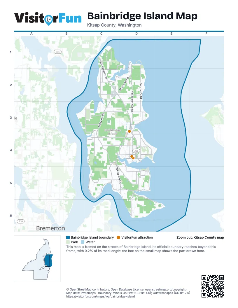
Street index of Bainbridge Island
Each street on the sheet and the grid squares it crosses.
- State Highway 305C1, C2, D2, D3, D4
- Bainbridge Island Ferry TerminalD4
- Olympic Drive SoutheastD4
- Sunrise Drive NortheastD1, D2, D3
- North Madison Avenue NortheastD2, D3
- Miller Road NortheastC2, C3, C4
- Northeast Eagle Harbor DriveC4, D4, D5
- Blakely Avenue NortheastC4, C5, D5
- Fletcher Bay Road NortheastC4
- Northeast High School RoadC4, D4
- Sportsman Club Road NortheastD3, D4
- Northeast Koura RoadC3, D3
- Phelps Road NortheastC2, D2
- Madison Avenue NorthD4
- Euclid Avenue NortheastD1, D2
- Northeast Day Road EastC2, D2
- Rockaway Beach Road NortheastD5
- Northeast Valley RoadD3
- Northeast Day Road WestC2
- Wyatt Way NorthwestC4, D4
- High School Road NortheastD4
- Northeast Lafayette AvenueD1
- Northeast Bucklin Hill RoadC4
- Northeast Halls Hill RoadD5
- Winslow Way EastD4
- Finch Road NortheastD4
- Madison Avenue SouthD4
- Crystal Springs Drive NortheastC4, C5
- Northeast Country Club RoadD5, D6, E6
- Northeast Hidden Cove RoadC2, D2
- Battle Point Drive NortheastC3
- Northeast New Brooklyn RoadC4, D4
- Northeast Baker Hill RoadC5, D5
- Old Mill Road NortheastC4, C5, D5
- Ferncliff Avenue NortheastD3, D4
- Arrow Point Drive NortheastC3
- Pleasant Beach Drive NortheastC5, D5, D6
- Fort Ward Hill Road NortheastD5, D6
- Point White Drive NortheastC5
- Springridge Road NortheastC3, C4
- Lynwood Center Road NortheastC4, C5
- Manzanita Road NortheastC2
- Northeast West Port Madison RoadC1, C2
- Northeast Tolo RoadB3, C3
- Taylor Avenue NortheastD5
- Grand Avenue NortheastD4
- New Sweden Road NortheastD5
- Manitou Beach Drive NortheastD3
- Grow Avenue NorthwestD4
- Komedal Road NortheastC2
- Agate Pass Road NortheastC1
- Henderson Road NortheastC2
- Northeast Old Creosote Hill RoadD5
- Wing Point Way NortheastD4
- Agatewood Road NortheastC1
- Agate Point Road NortheastC1
- Ericksen Avenue NortheastD4
- Northeast Manitou Beach DriveD3
- Moran Road NortheastD3, D4
- Northeast Yaquina AvenueD3, D4
- Northeast Bergman RoadC2
- Northeast Oddfellows RoadC5, D5
- Falk Road NortheastD3
- Northeast Dolphin DriveC1
- Wing Point Road NortheastD4
- Blakely Hill Road NortheastD5
- West Blakely Avenue NortheastD5
- Northeast Foster RoadC4
- Winslow Way WestD4
- Northeast Lofgren RoadD3
- Northeast County Park RoadC1, D1
- Park Avenue NortheastD4
- Northeast Frey AvenueC3
- Northeast Ralston RoadC2
- Northeast North StreetC1
- Northeast Fletcher Bay RoadC4
- Wallace Way NortheastD4
- Wyatt Way NortheastD4
- Northeast Seabold RoadC2
- Mandus Olson Road NortheastC3, C4
- Northeast South Beach DriveD6
- Sands Avenue NortheastC3, C4
- Toe Jam Hill Road NortheastD5, D6
- Hansen Road NortheastC4
- Kallgren Road NortheastD2, D3
- Northeast Upper Mill RoadD6
- Island Center Road NortheastC4
- Northeast Lovgreen Road WestC3, D3
- Sivertson Road NortheastC2
- Northeast Wardwell RoadD3
- Meadowmeer Circle NortheastC3, D3
- Northeast Twin Ponds RoadC4
- Northeast Bay Hill RoadC3
- Cherry Avenue NortheastD4
- Point Monroe Drive NortheastD1
- Northeast Kitsap StreetD6
- Weaver Road NorthwestD4
- Northeast Torvanger RoadD2
- Pool & Gym Access RoadD4
- Ellingsen Road NortheastD2
- Hyla Avenue NortheastD3
- Northeast Yeomalt Point DriveD4, E4
- Northeast Sumanee PlaceC2, D2
- Northeast Beach Crest DriveD3
- Rose Avenue NortheastD5
- Washington Avenue NortheastD1, D2
- Northeast Vincent RoadC4
- Olympic Terrace Avenue NortheastC3
- Northeast Lovgreen Road EastD3
- Olympus Beach Road NortheastB3, C3, C4
- Lovell Avenue NorthwestD4
- Palomino Drive NortheastC5
- Northeast Winther RoadD3
- Northeast Darden LaneD6
- Northeast Tani Creek RoadD5
- Reitan Road NortheastC1
- Northeast Seaborn RoadD5
- Rockaway Bluff Road NortheastD5
- Old Woods Lane NortheastC4, C5
- Peterson Hill Road NortheastC2, C3
- Northeast North Tolo RoadB3, C3
- McDonald Avenue NortheastD5
- Yama Ridge LaneD5
- Ridge Lane NortheastC4
- Northeast Beck RoadC5, D5
- Northeast War Admiral LaneC3, D3
- Northeast Park View DriveD6
- North Town Drive NortheastD3, D4
- Rose LoopD5
- Northeast Spargur Loop RoadD2
- Northeast Tara LaneC5
- Lytle Road NortheastC5
- Northeast Bolero DriveD5, D6
- Commodore Lane NorthwestD4
- Country View Lane NortheastD6
- Windsong Loop NortheastD3
- Teem Loop NortheastC2
- Soundview Drive NortheastD6
- Skogen Lane NortheastC1, C2, D2
- El Cimo Lane NortheastC5
- Fox Cove Lane NortheastC3, C4
- Upper Farms Road NortheastE6
- Hart Lane NortheastC3
- Barkentine Road NortheastD5
- Arrow Point Loop NortheastC2, C3
- Manitou Park Boulevard NortheastD3
- Northeast Venice LoopC3
- Skinner Road NortheastB3, C3
- Deerpath Lane NortheastC5
- Holly Farm Lane NortheastC3, C4
- Misty Vale Place NortheastD2
- Northeast Murden Cove DriveD3
- Northeast Roberts RoadD3
- Haley Loop NortheastC4
- Bucsit Lane NortheastD3
- Diamond Place NortheastC5
- Northeast Walden LaneC4
- Northeast Marshall RoadC4
- Northeast Berganio RoadC4
- Sorrel Way NortheastC5
- Village Circle NorthwestD4
- Agate Street NortheastC1
- Capstan Drive NortheastD4
- Northeast Cambridge Crest WayD2
- Broomgerrie RoadD4
- Lariat Loop NortheastC5
- Northeast Wild Cherry LaneC4
- Hawley Way NortheastD4
- Hidden Heights Lane NortheastC2
- Island Avenue NortheastC5
- Olallie LaneB3
- Northeast Wing Point DriveD4
- Opal Ridge LaneC5
- Northeast Triple Crown DriveD3
- Northeast North Town LoopD3, D4
- Northeast Sunset LoopC3
- Madrona Drive NortheastD4, E4
- Westerly Lane NortheastC4
- Northeast Mary Sam LaneD2
- Douglas Drive NortheastD6
- Northeast Bill Point DriveD5
- Shepard Way NorthwestD4
- Justin Court NortheastC3
- Woodbank Drive NortheastC4
- Aaron Avenue NortheastD4
- Northeast Monte Vista DriveC3
- Northeast Dingley RoadD4, E4
- Northeast Laughing Salmon LaneD3, D4
- Fairmont Lane NortheastD3
- Hemlock Avenue NortheastD3, D4
- Eakin Drive NorthwestD4
- Northeast Blakely Heights DriveC5
- Bjune Drive SoutheastD4
- Alder Avenue NortheastD4
- Broom Street NortheastD1
- Northeast Grizdale LaneC4, D4
- Northeast Sunrise Bluff LaneD2
- Northeast Gregg Farm LaneC4
- Manzanita Park TrailC2
- Wood Avenue SouthwestD4
- Roe Road NortheastC2
- Strawberry Hill ParkC4
- Northeast Buckskin LaneC5
- Secretariat Lane NortheastD3
- Springwood Avenue NortheastD4
- Northeast Gertie Johnson RoadD3
- Northeast Knight RoadD2
- Gowen Place NorthwestD4
- Northeast Brownell LaneD6
- Northeast Williams LaneC3
- Harbor Crest Drive NortheastD4
- Northeast Caramella LaneC4, D4
- Silven Avenue NortheastC2
- Northeast Paulanna LaneC3, D3
- Northeast Ledgestone LoopC4
- Northeast Morgan RoadD3
- Cave Avenue NortheastD4
- Northeast McRedmond LaneD3
- Northeast Mill Heights CircleD5
- Northeast Sanwick PlaceC1
- Northeast Byron DriveD4
- Northeast Latyson LaneC5
- Quail Hill Road NortheastC4, D4
- High School Loop NEC4
- Northeast Viewcrest AvenueD3
- Northeast Puget Bluff LaneD2
- Welfare Avenue NortheastD5
- Northeast Pointview DriveD6
- Northeast Coyote Farm LaneC3
- Wimsey Lane NortheastD5
- Birkland Road NortheastD5
- Northeast Mountain View RoadD3
- Northeast Abies DriveC3
- Northeast Meadowmeer RoadC3, D3
- Parfitt Way SouthwestD4
- Northeast Sundance LaneC5
- Cosgrove Street NorthwestD4
- Southern Cross Road NortheastD5
- Bluff Lane NortheastC5
- Stromville LaneC2
- Moji Lane NorthwestD4
- Northeast Sunny Hill CircleD6
- Fieldstone Lane NortheastC3
- Logg Road NortheastD3
- Cherry Orchard Lane NortheastC4
- Tiffany Meadows Drive NortheastD4
- Northeast Dapple CourtC5
- Forest Lane NortheastC3
- Beans Bight Road NortheastD6, E6
- Kono Road NortheastD5
- Northeast Mitchell LaneC4
- Mattson Place NortheastC5
- Northeast Rhodes End RoadC5
- Summer Hill Lane NortheastD3
- Kirk Avenue NortheastC3
- Two Creeks Road NortheastC3
- Northeast Avalon LaneC5, D5
- Northeast Woodhaven LaneD2
- Northeast Agate BluffC1
- Island Center CemeteryC4
- Wintergreen Ln NED4
- Northeast Salmon Run LaneC3, C4
- Fort StreetD5
- Eagle Cliff Road NortheastD4
- Spargur Loop Road NortheastD2
- Northeast Manor LaneD2
- Nakata Place NorthwestD4
- Northeast Crystal LaneC5
- Northeast Brackenwood LaneD2
- Yankee Girl Circle NortheastD5
- Rose Loop NortheastD5
- Eagle Harbor LaneD4
- Pinyon Avenue NortheastC3
- Tunnelwood Court NortheastD5
- Martin Luther King Jr. BoulevardD4
- Northeast Gordon DriveD1
- Pita Lane NortheastC2
- Blue Sky Lane NortheastC4
- Northeast Crystal Springs Hill LaneC5
- Northeast Little Harbor LaneC2
- Lovell Avenue SouthwestD4
- Belfair Avenue NortheastD6
- Fairview Avenue NortheastD4
- Northeast Boulder PlaceD5
- Harvey Road NortheastC1, C2
- Parade Grounds Avenue NortheastD6
- Northeast Cessna LaneC5
- Wallace Way NorthwestD4
- Knechtel Way NortheastD4
- Northeast Maxwell LaneC3
- Coppertop Loop NortheastD3
- Azalea Avenue NortheastD4
- Ferryview Lane NortheastD4
- Flying Goat Avenue NortheastC5
- Grotle Street NortheastD1
- Hildebrand Lane NortheastD4
- Madrona Way NortheastD4
- Tangleberry Lane NortheastC5
- Dalton Lane NortheastD2
- Duncan Lane NortheastD3
Things to do on the Bainbridge Island map
Places on the map
- Agate Passage
- Bainbridge Island Fire District
- Barnabee Farm
- Battle Point Park
- Blakely Harbor
- Blakely Harbor Park
- Coppertop Park
- Dave Ullin Open Water Marina
- Eagle Harbor
- Fay Bainbridge Park Campground
- Fletcher Bay
- Fort Ward Historic District
- Fort Ward Park
- Gazzam Lake
- Gazzam Lake Nature Preserve
- Grand Forest East
- Grand Forest North
- Grand Forest West
- Hedley Spit
- Hidden Cove
- Hilltop
- Ios Ranch
- Islandwood
- Manitou Beach
- Manzanita Bay
- Manzanita Park
- Meadowmeer Golf & Country Club
- Meigs Park
- Murden Cove
- Nute's Pond Park
- Point Monroe Lagoon
- Port Madison
- Port Madison Bay
- Port Orchard
- Pritchard Park
- Quitslund Preserve
- Rich Passage
- Rockaway Bluff Preserve
- Rolling Bay
- Wing Point Golf Course
Next to Bainbridge Island
© OpenStreetMap contributors, Open Database License, openstreetmap.org/copyright · Map data: Protomaps · Boundary: Who's On First (CC-BY 4.0); Quattroshapes (CC BY 2.0)















