

Washington map
Bremerton map
About 45,291 people live here (Census Bureau, 2024 estimate). The sheet's index lists 300 streets; State Highway 3 Southwest, State Highway 3 Northwest and Kitsap Way cross the most grid squares. Things to do inside the boundary: USS Turner Joy and Puget Sound Navy Museum.
Open the map (PDF, US Letter)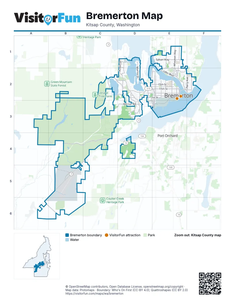
Street index of Bremerton
Each street on the sheet and the grid squares it crosses.
- State Highway 3 NorthwestD1, D2, D3
- State Highway 16D4
- State Highway 3 SouthwestB4, C4, B5, A6
- Kitsap WayC2, D2, E2
- Wheaton WayE1, E2
- 6th StreetD2, E2
- Burwell StreetD2, E2
- Warren AvenueE2
- Charleston BoulevardE2, D3, E3
- Callow Avenue NorthE2
- Auto Center WayD2, D3
- Pacific AvenueE2
- Warren Avenue BridgeE2
- Rodgers StreetD3, E3
- State Highway 3 WestC4
- 18th StreetE2
- Ferry Lane 1E2
- Ferry Exit Tunnel to Burwell AvenueE2
- Washington Avenue Ferry ExitE2
- State Route 303E1
- Southwest Bay StreetD4
- West Belfair Valley RoadB4, C4
- 11th StreetD2, E2
- Sheridan RoadE1, E2
- Sylvan WayE1
- Werner RoadC3, D3
- Perry AvenueF2
- Trenton Avenue NortheastF2
- Lebo BoulevardE2
- 1st StreetD2, E2
- Pine Road NortheastE1, E2
- Northeast Riddell RoadE1
- Southwest Lake Flora RoadA6, B6
- Tracyton Beach Road NorthwestE1, E2
- Washington AvenueE2
- Northlake Way NorthwestC2
- Pitt AvenueE2, F2
- Lafayette Avenue SouthE2, E3
- East 11th StreetE2, F2
- Manette BridgeE2
- Perry Avenue NortheastF2
- Adele AvenueD2
- Marion Avenue NorthD2
- Arsenal WayD3
- Marion Avenue SouthD2, D3
- National Avenue NorthD2
- Patten AvenueD3, E3
- West Loxie Eagans BoulevardD3
- North National AvenueD2
- Chico Way NorthwestC2
- Harkins StreetE2
- North Marion AvenueD2
- Farragut AvenueE2, E3
- Marine DriveD1, D2
- Wycoff Avenue NorthE2
- 13th StreetD2, E2
- Austin DriveD1, D2
- Harlow DriveC2, D2
- 15th StreetD2, E2
- Southwest Barney White RoadB5
- Naval AvenueE2
- Almira DriveE1
- Cambrian Avenue SouthE2, D3, E3
- High AvenueE2
- Imperial Way SouthwestB5
- Callahan DriveE2
- Sinclair WayD3
- Kitsap Lake Road NorthwestC2
- Cascades Pass BoulevardD1, D2
- Cherry AvenueE1, E2
- East Phinney Bay DriveD2, E2
- Union AvenueD3
- Oyster Bay Avenue SouthD3
- Auto Center BoulevardD2, D3
- Higbee RoadD1
- Corbet DriveD2
- Clare AvenueE1, E2
- Anderson Hill Road SouthwestD4
- Roosevelt BoulevardD3
- Lyle AvenueD2
- Price Road NorthwestD2
- 3rd Avenue WestD3
- Rocky Point RoadD2
- South Hartford AvenueD2, D3
- Juniper StreetE2
- Price RoadC2, D2
- Preble StreetD3, E3
- North Oyster Bay AvenueD2
- Bruen AvenueD2
- Farragut StreetD3, E3
- Snoqualmi Pass StreetD1
- Southwest Old Clifton RoadB5
- Kean BoulevardD3
- South Oyster Bay AvenueD2, D3
- 26th StreetE2
- Olding RoadD2
- Almira Drive NortheastE1
- Bremerton BoulevardD2
- West Kitsap Lake RoadC2
- Northwest Phinney Bay DriveD2
- 9th StreetD2, E2
- 5th StreetD2, E2
- Airport Way SouthwestB5
- Shore DriveE2, F2
- 4th StreetE2
- Baker Heights LoopD3
- 8th StreetE2
- North Lafayette AvenueE2
- Decatur AvenueE2, E3
- Rainier Avenue NorthE2
- Olympic AvenueE2
- Southwest Imperial WayB5
- Shorewood DriveD2
- 10th StreetE2
- Park AvenueE2
- Spruce AvenueE1, E2
- Nipsic AvenueF2
- Schley BoulevardE2
- Montgomery Avenue NorthE2
- Chester AvenueE2
- 7th StreetE2
- Petersville Road NortheastE1
- Lakehurst DriveD2
- Bree Drive SouthwestB5, C5
- Osprey CircleD2
- Russell RoadD2, D3
- Panoramic LoopC3, D3
- McKenna Falls Road WestA4, B4
- Snyder AvenueE2
- Mahan AvenueE2
- Winfield AvenueE2
- Hewitt AvenueE2
- 12th StreetE2
- East 31st StreetE1
- South Summit AvenueE2, D3, E3
- Ford AvenueE2
- Pennsylvania AvenueE2
- Madrona Point DriveD2
- Jacobson BoulevardF2
- 19th StreetD2, E2
- Carr BoulevardD2
- Wycoff AvenueE2, E3
- East 30th StreetE1, F1
- Veneta AvenueE2
- Cascade TrailE2, F2
- Boone RoadD1
- McCormic Village DriveD4
- East 16th StreetE2, F2
- 17th StreetD2, E2
- Gold Mountain Golf CourseB4, C4
- Maritime Drive SouthwestD4
- Dora AvenueD2
- Vandalia AvenueF2
- Ironsides AvenueF2
- Bloomington AvenueE2
- Halverson AvenueE1, E2
- Rickey RoadE1, E2
- Cambrian AvenueE2
- Marguerite AvenueE2
- Gregory WayE2
- Pearl StreetE1
- Broadway AvenueE2
- Ohio AvenueE2
- Minard Road WestA4
- Hayward AvenueF2
- Robin AvenueE1
- Stevens Pass DriveD1, D2
- East 18th StreetE2, F2
- Bay Vista BoulevardD2
- Elizabeth AvenueE2
- South Yantic AvenueD2, D3
- Cambrian Avenue NorthE2
- Mt. Baker Pass AvenueD1, D2
- Narrows View Lane NortheastE1
- North Summit AvenueD2, E2
- Lower Marine DriveD2
- East 13th StreetE2, F2
- Magnuson WayE2, F2
- Fir AvenueE2, F2
- Wilmont StreetD2
- East 33rd StreetE1
- Flat Top DriveD4
- Barclay AvenueE2, E3
- Walnut StreetE2
- Portside DriveD4
- Ivy RoadE1
- Wencker CircleD1, D2
- Peary RoadE2, E3
- Sulphur Springs Lane NorthwestE1
- Montgomery Avenue SouthE2, E3
- West StreetE2, E3
- Hanford AvenueE1
- Highland AvenueE2
- Bertha AvenueD2
- Pleasant AvenueE2
- Willow StreetE2
- East 17th StreetE2, F2
- Hemlock StreetE2
- Lafayette Avenue NorthE2
- McKenzie AvenueE2
- Seringa AvenueE2
- GM-4B3
- Sanders AvenueE1, E2
- East 10th StreetE2, F2
- Dewey StreetE2, E3
- Sereno Circle DriveD2
- East 19th StreetE2, F2
- Bayview Drive WestD3
- Poindexter Avenue WestD3
- Chestnut StreetE2
- Holman StreetF2
- J StreetE2, D3, E3
- McClain AvenueE1, E2
- South Callow AvenueE2, E3
- Brentwood DriveD2
- Constitution Avenue SouthD3
- Southwest Puget Sound BoulevardD4
- Nollwood Lane WestD3
- Timberline AvenueD3
- Wilbert AvenueD2
- Times AvenueE2
- H StreetE2, D3, E3
- Northeast Stone WayF2
- Bremerton Boulevard WestD3
- Deadwood StreetD2
- Pendergast ParkwayD3
- Marlow AvenueE2
- Cole AvenueE2
- Constance Drive SouthwestB5
- Oak StreetE2
- Cogean AvenueE2
- Autoplex BoulevardD3
- Bristlecone DriveE1
- Coghlan StreetE2, E3
- Sugar Pine DriveE1
- Arvon AvenueE2
- Bradley StreetE1
- Garland Lane NortheastE1
- Thompson DriveE2
- Veldee AvenueE2
- Stephenson AvenueE2
- Charleston Avenue SouthD3
- Eastlake DriveD2
- Lake DriveC2, D2
- North Cambrian AvenueE2
- Roosevelt AvenueE2
- Dibb StreetE1
- Hefner AvenueE2
- South AvenueE3
- Terrace StreetF2
- Gillette AvenueE1
- Hollis StreetE1
- Lincoln AvenueE2
- Worrall DriveE1
- Westview DriveE1
- Homer R Jones DriveE2
- White Pass StreetD1
- East 9th StreetF2
- Ida Street WestD3
- Zeedan WayE2
- East 32nd StreetE1
- Granger StreetD3
- West Hills BoulevardD3
- Cedargrove Street NortheastE1
- Taft AvenueE2
- Ash StreetE2
- Northeast Alder StreetF2
- Monticola DriveE1
- Sundown DriveD2
- Maple AvenueE1
- Phillips AvenueE1
- Elm StreetE2
- Helicopter PadD1
- Sylvan Pines CircleE1
- NE Nantucket StE1
- Pronghorn PlaceE1
- K StreetE2, E3
- Nome DriveE1
- Terrell AvenueE2
- West Reba WayC3
- Brashem AvenueF2
- Chinook Pass StreetD1
- Solie AvenueE1
- Harbel Drive NortheastE1
- Lansing Avenue WestD3
- Meade AvenueE2
- Porter StreetD3, E3
- Southwest Nixon LoopB5
- 14th StreetE2
- Morong RoadE2
- Cottman AvenueD3
- Eagle AvenueE1
- The CedarsD2
- Charlotte AvenueD2
- Sand Dollar StreetD2
- South Marine DriveD2
- Sophie StreetD3
- U StreetE2, E3
- 24th StreetE2
- Northeast 31st StreetE1
Things to do on the Bremerton map
Places on the map
- Alexander Lake
- Alpine U Cut Christmas Trees
- Amazon DSE8
- Anderson Cove
- Armin Jahr Elementary School
- Bay Vista Preserve
- Belfair Trap & Skeet Club
- Blueberry Park
- Bremerton High School
- Bremerton Marina
- Bremerton Raceway
- Bremerton Watershed
- Camp McKean
- Charleston Base
- Crownhill Elementary School
- East Park
- Elandan Gardens
- Elwood Point Recreation Area
- Gold Mountain Golf Course
- Hammer Head
- Heins Lake
- Imperial Way Southwest
- John Stanley Trail
- Kitsap Lake
- Lions Park
- Mud Bay
- N.A.D. Marine Park
- N.A.D. Soroptimist Park
- Naval Base Kitsap-Bremerton
- Naval Hospital Bremerton
- Ostrich Bay
- Oyster Bay
- Pendergast Regional Park
- Phinney Bay
- Port Washington Narrows
- Puget Sound Naval Shipyard
- Union River Reservoir
- USS Parche Sail
- View Ridge Elementary School
Next to Bremerton
© OpenStreetMap contributors, Open Database License, openstreetmap.org/copyright · Map data: Protomaps · Boundary: Who's On First (CC-BY 4.0); Quattroshapes (CC BY 2.0)















