

Washington road map
Cascade Loop map
The Cascade Loop has been a National Scenic Byway since 2021, named for its scenic qualities: a loop of about 425 miles in Washington. It meets 19 highways, among them I-5, US 2 and US 97. Towns along it: Everett, Lake Stevens and Wenatchee.
Open the map (PDF, US Letter)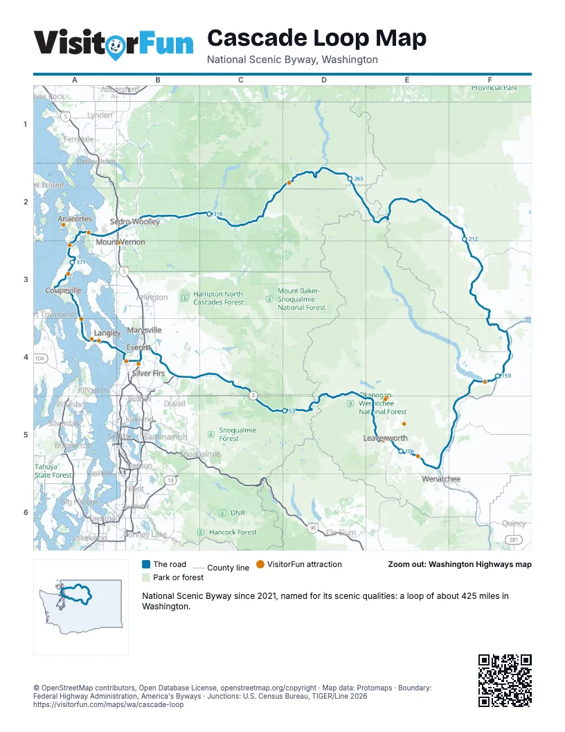
Highways it meets
Each highway it meets and the grid squares where they meet.
- US 2B4
- WA 522B4
- WA 203B4
- WA 2B4
- WA 207E5
- US 97E5
- WA 285E5
- US 97AE5
- WA 97AE5
- WA 971F5
- WA 150F4
- WA 153F4
- WA 20F3
- WA 530C2
- WA 9B2
- I-5B2
- WA 536A2
- WA 525A3
- WA 526B4
Towns along the Cascade Loop
In mile order, with the grid square of each.
- Everettmile 0, B4
- Lake Stevensmile 2, B4
- Fobes Hillmile 3, B4
- Bunk Fossmile 3, B4
- Snohomishmile 5, B4
- Chain Lakemile 10, B4
- Monroe Northmile 12, B4
- Monroemile 13, B4
- Woods Creekmile 17, B4
- Sultanmile 22, B4
- North Sultanmile 23, C4
- Startupmile 25, C4
- Gold Barmile 28, C4
- May Creekmile 30, C4
- Indexmile 37, C4
- Baringmile 41, C4
- Skykomishmile 49, C5
- Leavenworthmile 98, E5
- Cashmeremile 111, E5
- Sunnyslopemile 117, E5
- Wenatcheemile 119, E5
- Entiatmile 135, F5
- Chelanmile 153, F4
- Paterosmile 175, F4
- Methowmile 184, F3
- Twispmile 205, F3
- Winthropmile 214, F2
- Marblemountmile 297, C2
- Concretemile 316, C2
- Hamiltonmile 329, B2
- Lymanmile 332, B2
- Sedro-Woolleymile 339, B2
- Burlingtonmile 346, B2
- Anacortesmile 358, A2
- Whidbey Island Stationmile 368, A3
- Oak Harbormile 372, A3
- Coupevillemile 383, A3
- Freelandmile 399, A4
- Clintonmile 411, A4
- Mukilteomile 414, B4
- Eastmontmile 420, B4
Things to do on the Cascade Loop map
- Leavenworth Adventure Park
- Front Street
- Family Lines Fly Fishing Academy
- Cashmere Museum and Pioneer Village
- Apple Annie Antique Gallery
- Slidewaters
- North Cascades National Park
- Swinomish Casino & Lodge
- Deception Pass State Park
- Pacific Northwest Naval Air Museum
- Island County Historical Museum
- Whidbey and Camano Islands
- Ebey's Landing National Historical Reserve
- Price Sculpture Forest
- Whidbey Art Trail
- Earth Sanctuary
- Bayview Corner
- Boeing Future of Flight
- Everett Mall
- Imagine Children's Museum
© OpenStreetMap contributors, Open Database License, openstreetmap.org/copyright · Map data: Protomaps · Boundary: Federal Highway Administration, America's Byways · Junctions: U.S. Census Bureau, TIGER/Line 2026















