

Washington map
Lacey map
About 58,644 people live here (Census Bureau, 2024 estimate). The sheet's index lists 300 streets; Carpenter Road Southeast, Orion Drive Northeast and College Street Southeast cross the most grid squares. Also on it: Hicks Lake, William Ives Trail and Britton Plaza.
Open the map (PDF, US Letter)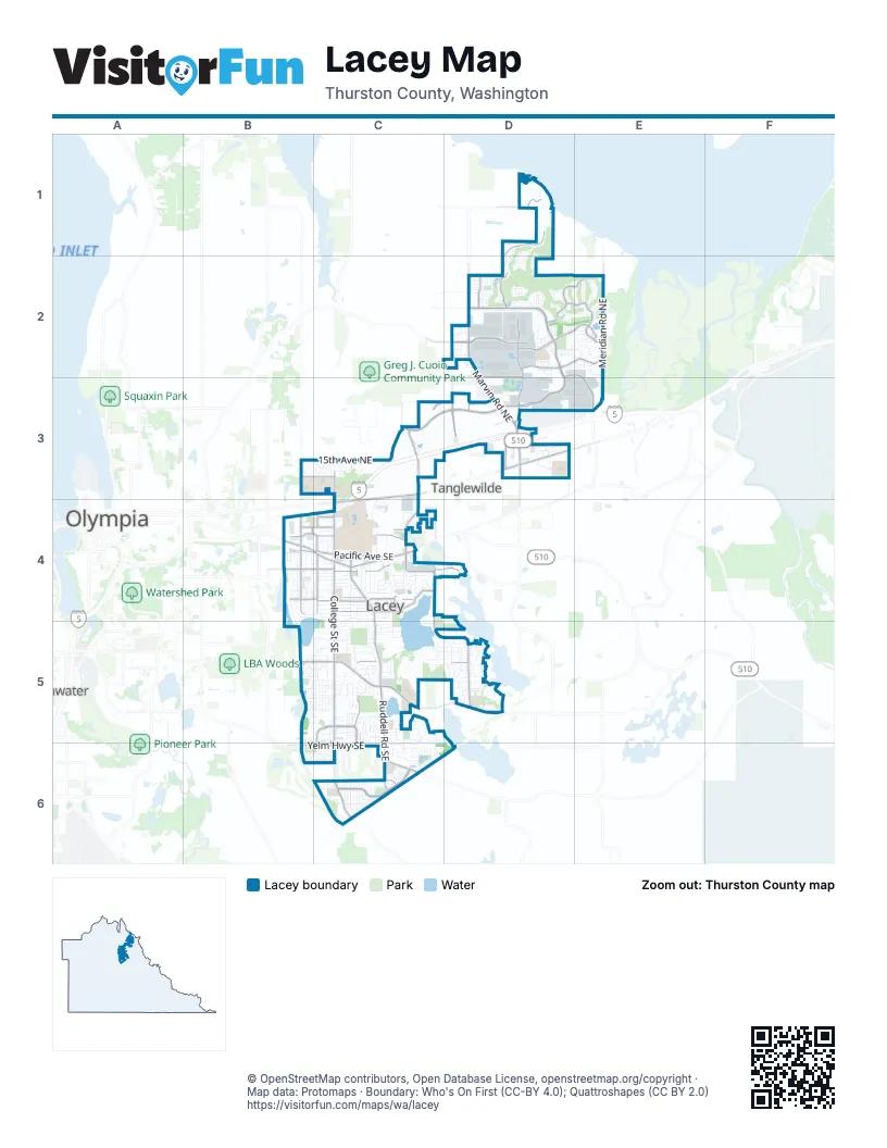
Street index of Lacey
Each street on the sheet and the grid squares it crosses.
- College Street SoutheastC4, C5, C6
- Marvin Road NortheastD2, D3
- Martin Way EastC3, D3, C4
- Pacific Avenue SoutheastB4, C4
- Lacey Boulevard SoutheastB4, C4
- Marvin Road SoutheastD3
- Carpenter Road SoutheastC3, C4, C5, D5
- Ruddell Road SoutheastC4, C5, C6
- Yelm Highway SoutheastB6, C6
- Sleater Kinney Road SoutheastB4
- Rainier Road SoutheastC6
- Quinault Drive NortheastD3
- Galaxy Drive NortheastD3
- West Mall Drive NortheastD3
- Willamette Drive NortheastD2, D3
- Britton Parkway NortheastC3, D3
- Mullen Road SoutheastC5, D5
- Balustrade Boulevard SoutheastC6
- 14th Avenue SoutheastB4, C4, D4
- Hawks Prairie Road NortheastD2
- 31st Avenue NortheastD2, E2
- Meridian Road NortheastE2, E3
- Hogum Bay Road NortheastD2, D3
- Vashon Drive NortheastD1, D2
- Orion Drive NortheastD2, E2, D3, E3
- 22nd Avenue SoutheastC4
- Golf Club Road SoutheastC4
- Gateway Boulevard NortheastD3
- Campus Glen Drive NortheastD2, E2
- 15th Avenue NortheastB3, C3
- 7th Avenue SoutheastB4, C4
- Campus Park Drive NortheastD2, E2
- Campus Highlands Drive NortheastD2, E2
- 25th Avenue SoutheastC4
- 37th Avenue SoutheastB5, C5, D5
- Parkside Drive SoutheastC5, C6
- Carpenter Road NortheastC3
- 6th Avenue SoutheastB4, C4
- 21st Avenue SoutheastB4, C4
- Shady Lane Road SoutheastC4
- Columbia Way NortheastD2
- Corporate Center Drive SoutheastC5, C6
- 66th Avenue SoutheastC6
- 53rd Avenue SoutheastC5
- 56th Avenue NortheastD1
- 6th Avenue NortheastC3
- Draham Street NortheastC3
- Edgewater Boulevard NortheastD2
- College Street NortheastC3, C4
- Birdseye Avenue NortheastC3, D3
- Sleater Kinney Road NortheastB3
- Stevens Drive NortheastE2
- Kinwood Street SoutheastC4
- 3rd Avenue SoutheastC4
- Callison Road NortheastD3
- Lilac Street SoutheastC4
- Golf Club PlaceB4
- Herman Road SoutheastB5
- 45th Avenue SoutheastB5, C5, D5
- Stikes Drive SoutheastC5
- Radius Loop SoutheastC6
- 39th Avenue SoutheastC5, D5
- Meriwood Drive NortheastD1, D2
- 16th Avenue SoutheastB4, C4
- Judd Street SoutheastC4, C5
- 15th Avenue SoutheastC4, D4
- 54th Avenue SoutheastC5
- Sierra Drive SoutheastC4
- 26th Avenue SoutheastC4
- 23rd Avenue SoutheastC4
- Compton Boulevard SoutheastC6
- 57th Avenue SoutheastC5, C6
- Woodland Square Loop SoutheastC4
- Bainbridge Loop NortheastD2
- 19th Avenue SoutheastC4
- Main Street NortheastD3
- 28th Avenue SoutheastC5
- 41st Avenue SoutheastC5, D5
- 24th Avenue SoutheastC4
- Camano Loop NortheastD2
- Brentwood Drive SoutheastC4, C5
- 5th Way SoutheastC4
- Intelco Loop SoutheastB5, C5
- Baran DriveC4
- Homann Drive SoutheastC4
- Stockton Street SoutheastC5, C6
- 18th Avenue SoutheastC4
- 33rd Avenue SoutheastC5, D5
- 37th Lane SoutheastC5
- Waldron Drive NortheastD1
- 50th Avenue SoutheastC5
- 36th Avenue SoutheastC5, D5
- Mountain Green Lane SoutheastC5, C6
- Komachin Loop SoutheastC5
- River Ridge Drive SoutheastD3
- Cameron Drive NortheastD2, E2
- Lebanon Street SoutheastC4
- 34th Avenue SoutheastC5, D5
- Malibu Drive SoutheastC4
- 38th Drive SoutheastD5
- Arbor Drive SoutheastD5
- Campus Drive NortheastE2
- Desmond Drive SoutheastC3, C4
- Park Place Loop SoutheastC5
- Deni Drive NortheastD2, E2
- 29th Avenue SoutheastC5
- Franz Street SoutheastC4
- Ingleside Drive SoutheastB5, C5
- Diamond Loop SoutheastC4
- Carpenter Hills Loop SoutheastD5
- 67th Avenue SoutheastC6
- 30th Avenue SoutheastC5
- Commerce Place Drive NortheastD3
- Diamond Road SoutheastC4
- Clearbrook Drive SoutheastC4
- Cashmere Drive NortheastD2
- Stanfield Road SoutheastD5
- 70th Way SoutheastC6
- 17th Avenue SoutheastC4
- London Loop NortheastD2
- 35th Avenue SoutheastB5, C5, D5
- Classic Drive NortheastE2
- Koala Street SoutheastC5
- Inlay Street SoutheastC6
- Prism Street SoutheastC6
- Brittany LaneD3
- Thornbury Drive SoutheastC5, C6
- Stone Street SoutheastC6
- Axis Street SoutheastC6
- 58th Avenue SoutheastC5, C6
- Bowker Street SoutheastC4
- Department of Ecology AccessC4
- Bailey Street SoutheastC6
- Sycamore Street SoutheastC4
- Willow Street SoutheastB4
- 46th Avenue NortheastD2, E2
- McKinley Street NortheastD2
- Alder Street SoutheastC4
- Mercedes Drive NortheastE2
- Beckonridge Lane SoutheastB6, C6
- Dogwood Street SoutheastC4
- Millstone Lane SoutheastC6
- Impala Drive SoutheastC5
- Lanyard Drive NortheastD2
- Litt Drive SoutheastD3
- Orcas Street NortheastD1, D2
- Hicks Lake Road SoutheastC4, C5
- Corporate Center Loop SoutheastC5
- Timberline Drive SoutheastD5
- Abbey Way SoutheastC4
- Gemini Street SoutheastC4
- Stonegate Street SoutheastC5
- Circle Lane SoutheastB4
- Periwinkle Loop NortheastE2
- Rainier Loop SoutheastC6
- Orcas Loop NortheastD1, D2
- Circle Loop SoutheastB4, C4
- 13th Avenue SoutheastB4, C4
- 20th Avenue SoutheastC4
- 56th Avenue SoutheastC5
- Lacey Street SoutheastC4
- Seville Drive SoutheastC5
- 14th Way SoutheastB4, C4
- Caddyshack Drive NortheastE2
- Compass Street SoutheastC6
- Ashdown Lane SoutheastC6
- 32nd Lane SoutheastC5
- Campus Meadows Loop NortheastD2, E2
- Whitman Lane SoutheastC6
- Polaris Lane NortheastD3, E3
- Westlake Drive SoutheastB4, B5
- Campus Green Drive NortheastD2
- Meadowbrook Lane SoutheastC5
- Pennsylvania Street SoutheastC6
- 33rd Court SoutheastC5
- 47th Avenue SoutheastC5
- Clearwater Loop SoutheastD5
- Flute Street SoutheastC6
- Turf Lane SoutheastC6
- Lake Hills Street SoutheastC5
- Yonkers Drive SoutheastC4
- Long Lake County Road SoutheastC5, D5
- Hoh Street SoutheastD3
- 61st Avenue SoutheastC6
- Goldfinch Drive SoutheastD5
- Clearwater Drive SoutheastD5
- Boardwalk Street SoutheastC5
- 25th Loop SoutheastC4
- 32nd Avenue SoutheastC5, D5
- Chambers Lake Lane SoutheastB4
- Lewis Drive NortheastE2
- Spokane Street NortheastD1, D2
- White Fir Drive NortheastE2
- Hanover Drive SoutheastC4
- Montclair Avenue SoutheastC5
- Bogey Drive NortheastE2
- 48th Avenue SoutheastD5
- Chambers Lake Drive SoutheastB4, C4
- 38th Avenue SoutheastC5, D5
- Chardonnay Drive SoutheastB6, C6
- Prestwick Lane SoutheastC6
- Ruddell Loop SoutheastC5
- Alanna Drive SoutheastC4
- City RowC4
- Eagle Loop NortheastD2
- Cypress Loop NortheastD1
- Anderson Court NortheastD1
- Greenlawn Street SoutheastC4, C5
- Hickory Stick Lane NortheastD3
- Ulery Street SoutheastC4
- Angela Street SoutheastC4
- Shirley Street SoutheastC4
- Campus Prairie Loop NortheastE2
- Gravel Lane NortheastC3
- Nelson Road SoutheastC5
- Dudley Court NortheastD2
- Afflerbaugh Drive SoutheastD5
- Illinois Lane SoutheastC6
- Vancouver Drive NortheastE2
- 55th Lane SoutheastC5
- Enterprise Drive NortheastC3
- Roxanna Loop SoutheastB5, C5
- 27th Avenue SoutheastC4, C5
- Jeri Drive NortheastD2, E2
- Electra Court SoutheastD5
- Hall Street SoutheastB4
- Apollo Street SoutheastC5
- Leisure Lane SoutheastB4
- Midway Drive NortheastC3
- Southlake Drive SoutheastD5
- Stephanie Loop NortheastE2
- 71st Avenue SoutheastC6
- Lakeview Court SoutheastC5
- Hanna Drive NortheastD2
- Spencer Avenue NortheastD2
- Maricite Street SoutheastC5
- 27th Lane SoutheastC4, C5
- Cherokee Loop SoutheastC6
- Freemont Street NortheastD2
- Glen Mary Drive SoutheastC4
- Chelan Lane SoutheastC5
- Marina Lane SoutheastB4
- Webster Drive NortheastD2
- Pattison Lake Drive SoutheastC5, D5, D6
- Virginia Street SoutheastC6
- 60th Loop SoutheastC6
- Alpha Street SoutheastC4
- Beltway Loop SoutheastC6
- 59th Loop SoutheastC6
- BriarcliffC5
- Village Drive SouthD5
- Hepburn Street NortheastD2
- Wildwood Trailer CourtD3
- 12th Avenue SoutheastB4
- Sidney Street SoutheastC5
- Christa Drive NortheastD2
- Fairhill Drive NortheastE2
- Hanna Lane NortheastD2
- Alhadeff LaneC4
- Belair Drive SoutheastC5
- Bend Drive NortheastD1, D2
- Campus Willows Loop NortheastD2
- 33rd Loop SoutheastD5
- Beta Street SoutheastB4
- Danials Loop SoutheastC6
- Magnolia Street SoutheastB4
- Sebastian Drive NortheastD2
- Ida Jane Way SoutheastC5
- Mount Tahoma Drive SoutheastC5
- Emerald Street SoutheastC5, C6
- Lacey City HallC4
- Beckonridge Loop SoutheastC6
- Timothy Street SoutheastC5
- Avonlea Drive SoutheastB5
- Bethany Court SoutheastC5
- 33rd Way NortheastD2
- Breeze Drive SoutheastC6
- 26th Loop SoutheastC4
- 43rd Avenue SoutheastC5, D5
- Cameron Lane NortheastD2
- 28th Court NortheastD3
- Abigail Drive NortheastD2
- Fire LaneC4
- Mossy Rock Avenue NortheastD2
- Delaware Avenue SoutheastC6
- 32nd Court SoutheastC5
- Woodland Loop SoutheastB4, C4
- Avery Lane SoutheastC5
- Wonderwood Lane SoutheastC5
- 29th Avenue NortheastD3
- 60th Avenue SoutheastC6
- Hercules Drive NortheastD2
- 44th Court SoutheastC5
- Yakima Lane SoutheastC5
- Boat Launch Street SoutheastC5, D5
- Jackson Farm Loop SoutheastC5
- Rumac Street SoutheastC5, C6
- Sulky Drive SoutheastC4
- Boone Street SoutheastB4
- Pilatus Avenue SoutheastB5, C5
Places on the map
- Britton Plaza
- Butterball Cove
- Chambers Lake Natural Area
- Chinook Middle School
- Costco
- CubeSmart
- Fred Meyer
- Gwinwood Retreat Center
- Hawks Prairie Shopping Center
- Hawks Prairie Timberland Library
- Hicks Lake
- Hogum Bay Buisness Park
- Hogum Bay Town Center
- Homann Park
- Horizon Pointe Park
- Horizons Elementary School
- I-5 Park
- Komachin Middle School
- Lacey Crossroads
- Lacey Downs Shopping Center
- Lacey Elementary School
- Lacey Marketplace
- Lacey Pack and Ship
- Lacey Plaza
- Lake Lois Park
- Lakepointe Park
- Little Prairie Center
- Market Square
- Martin Village
- North Thurston High School
- Rainier Vista Community Park
- River Ridge High School
- South Sound Behavioral Hospital
- South Sound Center
- Southwick Lake
- The Golf Club at Hawks Prairie - The Links
- Timberline High School
- William Ives Trail
- Wonderwood Park
- Woodland Square Office Park
Next to Lacey
- Olympia map
- Tanglewilde
- Tumwater map
© OpenStreetMap contributors, Open Database License, openstreetmap.org/copyright · Map data: Protomaps · Boundary: Who's On First (CC-BY 4.0); Quattroshapes (CC BY 2.0)















