

Wisconsin map
Madison map
About 285,300 people live here (Census Bureau, 2024 estimate). The sheet's index lists 64 streets; East Washington Avenue, University Avenue and County Road M cross the most grid squares. Things to do inside the boundary: Olbrich Botanical Gardens.
Open the map (PDF, US Letter)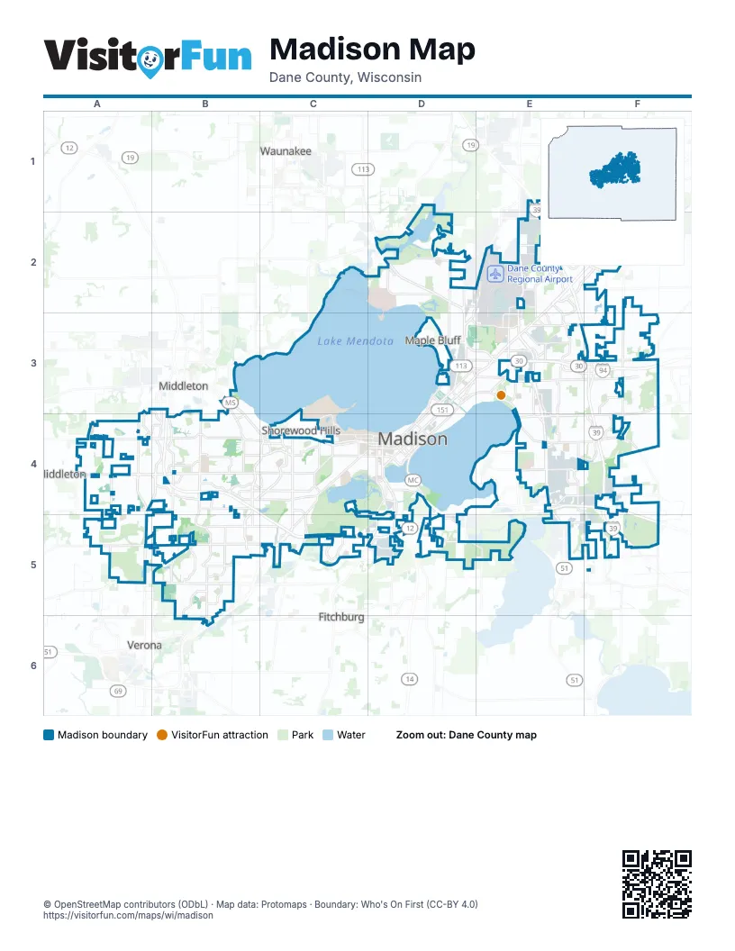
Street index of Madison
Each street on the sheet and the grid squares it crosses.
- County Highway CVD2
- County Road MD2, A4, B4
- Darwin RoadD2
- International LaneD2, E2, D3
- Northport DriveD2
- Packers AvenueD2, D3
- State Highway 113D2, D3
- East Washington AvenueE2, D3, E3, D4
- North Stoughton RoadE2, E3
- US Highway 51E2, E5
- Allen BoulevardB3
- University AvenueB3, B4, C4, D4
- Aberg AvenueD3, E3
- East Gorham StreetD3, D4
- East Johnson StreetD3, D4
- North First StreetD3
- Pennsylvania AvenueD3
- South First StreetD3
- County Highway TE3, F3
- South Stoughton RoadE3, E4, E5
- State Highway 30E3, F3
- Cottage Grove RoadF3, E4, F4
- Reiner RoadF3
- Sprecher RoadF3, F4
- Mineral Point RoadA4, B4, C4
- Pleasant View RoadA4
- South Pleasant View RoadA4, A5
- Gammon RoadB4
- Junction RoadB4
- North Gammon RoadB4
- Schroeder RoadB4
- South Gammon RoadB4, B5
- South Whitney WayB4, C4, B5
- West Beltline HighwayB4, C5, D5
- Campus DriveC4, D4
- Monroe StreetC4, D4
- Nakoma RoadC4, C5
- North Midvale BoulevardC4
- North Whitney WayC4
- Old Middleton RoadC4
- Regent StreetC4, D4
- South Midvale BoulevardC4, C5
- Speedway RoadC4
- Fish Hatchery RoadD4, D5
- John Nolen DriveD4
- North Park StreetD4
- North Randall AvenueD4
- North Shore DriveD4
- Proudfit StreetD4
- Rimrock RoadD4, D5
- South Blair StreetD4
- South Park StreetD4, D5
- West Gorham StreetD4
- West Johnson StreetD4
- West Washington AvenueD4
- East Buckeye RoadE4, F4
- South Beltline HighwayE4, F4, D5
- County Road PDA5
- McKee RoadA5, B5
- McKenna BoulevardB5
- Raymond RoadB5, C5
- Verona RoadC5
- Siggelkow RoadE5, F5
- County Road ABF5
Things to do on the Madison map
Places on the map
- 1000 Oaks Neighborhood
- 115th Fighter Wing Truax Field
- Acacia Ridge
- Acewood Park
- Airgas
- All Saints Neighborhood
- Allied
- American Family Insurance
- Amund Reindahl Park
- Arbor Hills
- Army National Guard
- Autumn Lake
- Bassett
- Bay Creek
- Berkley Oaks
- Big Woods
- Bill's Woods
- Blackhawk
- Bram's Addition
- Brentwood Village
- Bridge-Lakepoint
- Bridges Golf Course
- Burr Oaks
- Caretaker's Woods
- Castle Marsh
- Catholic Diocese of Madison
- Center for Industry & Commerce
- Central Wisconsin Center
- Cherokee Garden
- Cherokee Marsh
- Cherokee Marsh South Unit
- Cherokee Park
- Class of 1918 Marsh
- Country Grove Neighborhood Association
- Coventry Village
- Crawford Heights
- Curtis Prairie
- Dane County
- Dane County Humane Society
- Dane County Landfill
Next to Madison
- Fitchburg
- Maple Bluff
- Middleton
- Shorewood Hills
- Verona
- Waunakee
- West Middleton
© OpenStreetMap contributors (ODbL) · Map data: Protomaps · Boundary: Who's On First (CC-BY 4.0)