

Wisconsin map
Oconto County map
About 40,037 people live here (Census Bureau, 2024 estimate). The sheet's index lists 300 streets; State Highway 32, County Road T and State Highway 22 cross the most grid squares. Things to do inside the boundary: Copper Culture State Park and Visit Oconto County.
Open the map (PDF, US Letter)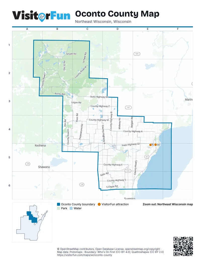
Street index of Oconto County
Each street on the sheet and the grid squares it crosses.
- State Highway 32A1, B1, B2, B3, C3, C4, C5
- State Highway 22C4, D4, C5, D5, E5
- State Highway 64A2, B2, B3, C3, D3
- US-141D5
- South Main StreetD5
- North Main StreetD5
- Charles StreetE5
- North Chestnut AvenueD5
- West Main StreetC5
- North McKenzie StreetC4, C5
- Union AvenueD5
- North McKenzie AvenueC4
- Nichole M. Frye Memorial BridgeD4
- County Highway SE5, C6, D6, E6
- County Road WB2, C2, A3, B3
- County Highway BD3, D4, D5
- County Highway MC4, D4
- County Road FB1, C1
- County Highway EC5, D5
- County Highway YE4, F4, E5
- County Highway DD5
- Sampson RoadD5, E5, E6
- Main StreetB2, D5, E5
- Park AvenueA1, E4, D5, E5
- Brazeau AvenueE4, E5
- East County Line RoadE4, F4
- County Highway WE4
- Smith AvenueE5
- Collins AvenueE5
- County Highway AC4, D4, E4
- County Road TA1, B1, A2, B2, A3, B3
- County Highway ZC3, D3, C4
- County Road JE5, D6, E6
- County Highway JE4, E5
- County Highway KC4, D4, D5
- Bonita RoadB2, B3
- County Road RB4, B5
- Red Banks RoadB4, C4, C5
- County Highway GC4, D4
- County Road CD5, D6
- Potawatomi RoadC4
- County Road HB4, C4
- Cross RoadD5, D6
- County Highway ID4, D5
- County Highway CD5, D6
- County Road GC4
- Island Lake RoadB2
- County Road CCC5, D5
- County Road VVB5, C5
- County Road CCCC5, D5
- Star Lake RoadB2
- County Road VC4, C5
- County Road MB4, C4
- Fireside RoadD4, D5
- North Brown County Line RoadD6
- County Highway NE5
- McComb Lake RoadB2, B3
- County Road AAB3
- Shawano Line RoadC5
- County Highway BBC5
- County Road WWE4
- County Road HHB5
- County Highway EED5
- Old 141 RoadD4
- County Highway PC5
- County Highway SSE5
- County Road UC5
- East Highland DriveD5
- County Highway WWE4
- East Main StreetC4, D4, C5
- County Road QD3
- Columbia StreetD5
- North Maple AvenueD5
- North Rosera StreetD4
- Brown RoadD6
- County Highway VC5
- Green Bay AvenueD5
- County Road BBC5
- Indian Rt 32B4
- Parkway RoadD2, D3, D4
- Tar Dam RoadB2, C2
- Old 32 RoadB1, B2
- Old Highway 64C2, B3, C3
- South Chase RoadC6, D6
- Airport RoadC2, C3, E5
- River RoadB2, C3, C4
- East Frontage RoadD5, D6
- Valley Line RoadC4, D4
- Goatsville RoadD4
- Forest Hill DriveA1, B1
- Geano Beach RoadD6, E6
- Logtown RoadE4, E5
- Archibald Lake RoadB1, A2, B2
- Oak Orchard RoadD5, E5
- Kruegers Quarry RoadD5, E5
- Jack Pine RoadC3
- Elm Lawn RoadD5
- Allen RoadD6, E6
- Lee Lake RoadC3, D3
- La Fave RoadC1, C2
- Riverview RoadC2
- Schroeder RoadC5, D5
- White Lake RoadC3, C4
- Sandalwood RoadD5, D6
- Timberline RoadD5
- Elm RoadB4
- Chickadee RoadC1
- West Frontier RoadD5, D6
- Pickerel Lake RoadB1
- Knowles Creek RoadB1
- Bell Bridge RoadE5
- Schwartz RoadD6
- Goldhorn RoadC3, D3
- Midway RoadD4
- Belgian RoadD4
- Konitzer RoadD5
- Gray Lake RoadC5, D5
- Peshtigo Brook RoadC3, C4
- Liegeois RoadD5, E5
- Valley View RoadA1, B1
- Maple Grove School RoadE4
- Daly Creek RoadC4
- Bucks Ranch RoadC1
- Lade Beach RoadD6, E6
- Mountain Lake RoadB2, B3
- Cream City RoadE4, E5
- Town Hall RoadC4, D5
- Gohr RoadC6, D6
- Claywood RoadC4
- Sunrise Lake RoadB2, C2
- Hill RoadB3, C3
- Maiden Lake RoadB2
- Military RoadD4, E4, D5
- Lake John RoadB1
- Guelig RoadD4
- Morgan Marsh RoadC5, D5
- Old 64 RoadC2, C3
- Smyth RoadB1, C1
- North Porcupine Lake RoadD4
- Delcore RoadE4
- Woodview RoadE4
- North River RoadE5
- Bachman RoadC2, C3
- Safian RoadC5, C6
- Jagiello RoadD4
- Yatso RoadC4, D4
- Saul Springs RoadA2
- North Fork RoadC1
- Peshtigo Brook Fire LaneC2, D2, C3
- Moody RoadE5, E6
- Holt Ranch LaneC1, C2
- Diamond Roof RoadA1
- Logan RoadB3, C3
- Peek RoadC1
- Klaus Lake RoadC4, C5
- Willow RoadB4, C4
- Balcom Lake RoadC4, D4
- Pipeline RoadC3
- Sullivan Spring RoadB1, B2
- Springside RoadD4
- West Stiles Tower RoadD5
- McCauley Creek RoadB2, C2
- Clay RoadC4
- Brock RoadC4
- Morgan River RoadC5, D5
- Busy Nook RoadD4
- Old 41 RoadE4, E5
- North Branch RoadC3
- Stiles RoadD5, E5
- Tower Drive RoadE4
- Arndt RoadD4
- Ucil Lake RoadC3
- Hogsback RoadE4
- Van Dornick RoadC6, D6
- Lower RoadD6
- Degantown RoadC5
- North RoadB1
- Sawyer Lake RoadA1, A2
- Weso Creek RoadB3
- Butler Rock RoadC2
- Sunshine RoadD4
- Swenty RoadC3
- Charolais RoadD4
- Brehmer RoadD5
- Kelly RoadB4
- South Range Line RoadE4
- Elm Grove School RoadE4, E5
- Golf Course RoadC4
- Sugarbush RoadE4
- Jaworski RoadD6
- Beaver Lake RoadD4
- Mountain Lakes RoadB2
- Little River RoadE4
- Pipgrass RoadD4
- Spring Hill RoadC4
- Bloom RoadB4, C4
- Marl Lake RoadC3
- Loon Rapids RoadB2
- Spreeman RoadC3
- South White Potato Lake RoadC3, D3
- Niemann RoadB2
- McCabe RoadB1
- Yurek RoadC6, D6
- Presbyterian RoadA1, B1
- Binder Lake RoadB1
- East Riverside RoadB1, C1
- Blue Spruce RoadB2
- Waubee Lake DriveB1, C1
- Brookside Cemetery RoadE5
- Olson RoadD4, D5
- National Forest Rd 2630B2, C2
- Mosquito Lake RoadA1
- Eickhoff RoadA2, B2
- Chestnut RoadD4, D5
- Burdosh RoadD5
- Nicolet RoadA1, B1
- Hickory Cemetery RoadC4
- Paya Lake RoadB2
- Deerhill RoadB4, B5
- Twin Pine RoadC3
- Chicken Shack RoadD5, E5
- Krakow RoadC5, D5
- Quarterline RoadC4, C5
- Hilbert RoadD6
- Nauke RoadC3
- Sundew RoadD6
- Swedetown RoadE4
- Molitor RoadD4, E4
- NF-203C3
- South Branch RoadB3
- Froelick RoadE5
- Heider RoadD5
- Four Towns RoadC4
- Vermeiren RoadE5
- Burg RoadD4, E4
- West Rost Lake RoadD3
- Section 4 LaneB2
- Tree Farm RoadB2
- North Maiden Lake RoadB2
- Rost RoadE6
- Lemere RoadD4, D5
- Valentine RoadD5, D6
- Sleeter RoadC3
- North Park Avenue RoadE4
- Horn Lake RoadA1
- Forrester RoadB1
- Martin LaneC2
- Sauls Spring RoadA2
- Janik RoadC4, D4
- Garrity RoadD5
- Wescott Lake RoadC3
- West Wheeler Lake LaneB1
- Gallon RoadE4
- Central RoadB3, C3
- Sherman RoadE4
- West Shay Lake LaneC2, C3
- Hidden Lake LaneB1
- Mourning Dove RoadD6
- McDonald StreetE5
- Meadowbrook RoadD4
- Shallow LaneB2, E4
- Old 22 RoadC5
- Brazeau Town Hall RoadD3
- Hale RoadF4
- 2 Mile RoadE4
- West River DriveD4
- Sunny Brook RoadD4
- Settlement RoadB4
- Dudzik RoadC5, D5
- Tom Post RoadD3
- Hillcrest RoadE4
- Holtz RoadC5, D5
- Yarwood Pond RoadC4
- Whiffen LaneB2
- Miller RoadD5
- Morgan RoadB4, C4
- Goldfield RoadD3
- Soukup RoadD3
- Section 8 Church RoadD3
- Hall RoadE4
- West South Shore DriveB3
- Thelen RoadB2
- Crawford RoadD5, E5
- Sandy Corners RoadC5
- Golden Corners RoadD5
- Harris RoadC3
- North Range Line RoadE4
- Fredrickson RoadD4, D5
- Silver Hill RoadB2
- Alder LaneC4
- Frog Pond RoadE5
- Lost Lake Area RoadC2
- Cook RoadE5
- Townline RoadE4
- Superior AvenueE4, E5
- Nelligan Lake LaneC2
- West Burnt Dam RoadA1
- Mueller Hill RoadC4
- Funk RoadE5
- Ridge RoadD4, D5
Things to do on the Oconto County map
Places on the map
- Anderson Lake
- Archibald Lake
- Balcom Lake
- Barnes Lake
- Bass Lake
- Bear Lake
- Bear Paw Lake
- Bear Paw Scout Camp
- Berry Lake
- Boot Lake
- Boulder Lake
- Boulder Lake Campground
- Camp U-Nah-Li-Ya
- Chain Lake
- Chequamegon-Nicolet National Forest - Lakewood-Laona District
- Chicken Foot Lake
- Christie Lake
- Chute Pond
- Cooley Lake
- Crooked Lake
- Explosion Lake
- Flower Lake
- Gillett
- Glocke Lake State Natural Area
- Hawthorn Road
- Horn Lake
- Impassable Lake
- John Lake
- Kelly Lake
- Lakewood XC Course
- Leigh Flowage
- Lena
- Little Archibald Lake
- Long Lake
- Machickanee Flowage
- Maiden Lake
- Munger Lake
- Nelligan Lake
- Oconto
- Oconto County Forest
Next to Oconto County
- Keshena / Kesīqnæh
- Marinette
- Shawano
- Suamico map
© OpenStreetMap contributors, Open Database License, openstreetmap.org/copyright · Map data: Protomaps · Boundary: Who's On First (CC-BY 4.0); Quattroshapes (CC BY 2.0)















