

California map
Tehama County map
About 64,451 people live here (Census Bureau, 2024 estimate). The sheet's index lists 300 streets; State Highway 36 East, Westside Freeway and Paskenta Road cross the most grid squares. Things to do inside the boundary: Gaumer's Jewelry & Museum and Lassen Volcanic National Park.
Open the map (PDF, US Letter)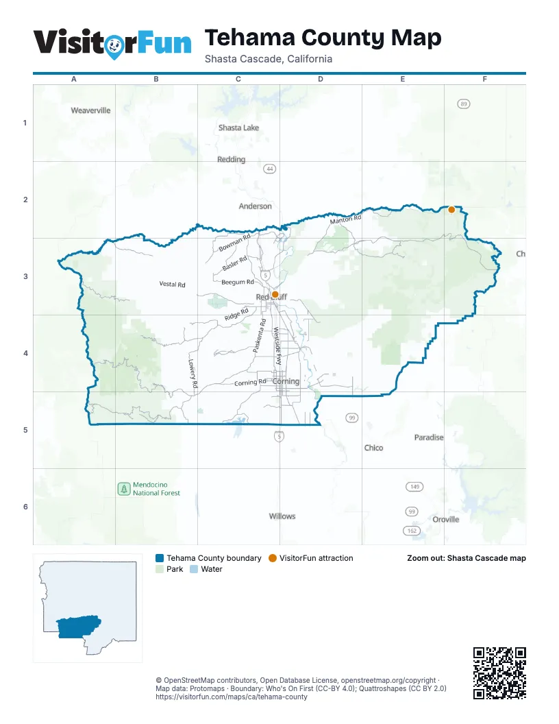
Street index of Tehama County
Each street on the sheet and the grid squares it crosses.
- Westside FreewayC3, C4, D4, D5
- Cascade Wonderland HighwayC2, C3
- State Highway 36 EastE2, F2, D3, E3, F3
- Beegum RoadC3
- State Highway 36 WestA3, B3
- Main StreetC2, C3
- Antelope BoulevardC3, D3
- State Highway 36D3
- Railroad AvenueD4
- Deer Creek HighwayE4
- Paskenta RoadC3, C4, B5, C5
- Rawson RoadC3, C4
- Road 99WC3, D3, D4
- Corning RoadC4, D4
- Bowman RoadC2, C3
- Newville RoadB5, C5
- Hall RoadD4, D5
- South AvenueC4, D4
- Gyle RoadC4, D4
- San Benito AvenueD4
- South Main StreetC3
- South Jackson StreetC3
- Hoag RoadD4
- Lassen Park RoadF2
- Solano StreetD4
- 5th StreetD4
- Jackson StreetC3
- Aramayo WayD4
- Lassen Peak HighwayF2
- C StreetD4
- East Solano StreetD4
- Paskenta-Eel River RoadA4, B4, A5, B5
- Paskenta-Mendocino Pass RoadA5, B5
- Rat Trap Gap RoadA3, B3
- Round Valley RoadB5
- Colyer Springs RoadB4, C4
- Red Bank RoadC3, B4, C4
- Lowery RoadB4, C4, B5
- Manton RoadD2, E2, D3
- Jellys Ferry RoadD2, C3, D3
- Reeds Creek RoadB3, C3
- Plum Creek RoadD3, E3
- Toomes Camp RoadB4, B5
- Old Corning RoadD4, D5
- Rancho Tehama RoadC4
- Basler RoadC3
- Forward RoadE2
- Little Giant Mill RoadE3
- Evergreen RoadC2, C3
- McCoy RoadC3
- Tapscott RoadC4, C5
- Hooker Creek RoadC2, C3
- Tyler RoadC3, D3, D4
- Lanes Valley RoadD2, D3
- Foothill RoadD3, D4
- Simpson RoadC4
- Capay RoadD5
- Lake California DriveC2, C3, D3
- Live Oak RoadC3, C4
- Benson RoadC3
- Tehama AvenueC4, D4
- Stagecoach RoadC4
- Toomes AvenueD4, D5
- Lassen RoadD4
- Kirkwood RoadD4, D5
- Shasta BoulevardD4
- Barham AvenueD4, D5
- Tehama Vina RoadD4
- Sour Grass RoadC5, D5
- Meridian RoadD4, D5
- Flournoy AvenueC5, D5
- Chittenden RoadC4, D4
- River View DriveC2, D2, C3
- 4th AvenueD4, D5
- Floyd LaneC2, C3
- Samson AvenueC4, D4
- Adobe RoadC3, D3
- 5th AvenueD4, D5
- Snively RoadC3
- Flores AvenueC4, D4
- Chard AvenueC4, D4
- Rowles RoadD4
- Truckee AvenueD4
- Paynes Creek LoopD3, E3
- Gerber RoadD4
- Wilder RoadC3
- Skyline DriveC3
- Luce and Griswold RoadC3
- Baker RoadC3
- Walnut StreetC3, D4
- Gallagher AvenueC4, D4
- Old Mission DriveC3
- Finnell AvenueC4, D4
- Vina RoadD4
- 68th AvenueD4
- Luning AvenueC4, D4
- Viola AvenueC4, D4
- Rio Alto DriveD2, C3, D3
- Auction Yard RoadC3
- Cone Grove RoadD3
- El Camino AvenueC4
- Wilcox RoadC3
- Dusty WayC4
- Freeman Schoolhouse RoadC4
- Black Butte RoadC4
- Liberal AvenueC5, D5
- Wildcat RoadD2
- Diamond AvenueC3
- Happy Valley TrailC3
- Luther RoadC3
- 6th AvenueC4, D4, D5
- 3rd StreetC3, D4
- Humboldt DriveC4
- Kimball RoadC3
- El Cajon DriveC3
- Monroe AvenueC3
- Monroe StreetC3
- Ventura AvenueD4
- A StreetD3
- 10th AvenueC4
- Wilcox Golf RoadC3
- Hickman LaneC3
- Humboldt RoadF3, F4
- The Oaks DriveC3
- Juaquin LaneC3
- 7th StreetD4
- 99W HighwayD5
- Road 313B5
- Rock Creek RoadE2
- Ponderosa WayE2, E3, E4
- Lassen TrailE3, F3
- Trough Ridge-Forks Ridge RoadA4, B4, A5, B5
- Vestal RoadB3
- Tedoc Gap RoadA3
- Valentine Ridge-Cold Springs RoadB4
- Yellow Jacket RoadE3
- Raglin Ridge RoadB4
- Pettyjohn RoadB3
- Ridge RoadC3, C4
- Lost Creek RoadF3
- Johnson RoadC3
- Forest Route 41A3
- Balis Bell RoadB3, C3, B4
- Long Hollow RoadC4, C5
- Cold Fork RoadA3
- Tramway RoadE3
- Commissary Springs-Log Springs RoadB5
- Bucks Flat RoadE3
- Pellows RoadB4
- Pine Creek RoadC3
- Matlock Loop RoadC3
- Quail Ridge RoadC3
- Houghton AvenueD4, D5
- Butte Mountain RoadC4, C5
- Boggs and Champlin RoadC4
- Cannon RoadB3, C3
- Leininger RoadD4
- Long GradeB3
- Bend Ferry RoadC3, D3
- Forest Route 25N19B4
- Tomhead Mountain RoadB3
- 29N22E2
- Weston RoadC4, C5
- Hogsback RoadD3
- Hillcrest DriveC4
- Eighmy RoadC2, C3
- Inskip RoadD3
- Kelly RoadB4, B5
- Inghram RoadD5
- McCarty Creek RoadB4, C4
- Stuart Gap RoadA3
- Oakridge RoadC4
- Canal View RoadC4
- Tedoc RoadA3, B3
- Oasis Spring Ranch RoadD2, E2
- Glenn RoadC4
- Reed Orchard RoadD4
- Walch AvenueD5
- Orchard AvenueC3, C4, C5
- Clark AvenueD5
- Weemasoul RoadB3
- Woodson AvenueD4, D5
- Lolita AvenueD4
- Osborn RoadC4
- East Canal RoadD3, D4
- Post AvenueD5
- Round Mountain RoadA3
- Moller AvenueD5
- Wilson StreetD4
- Marguerite AvenueD4, D5
- Pryor RoadB4
- Prettyjohn RoadB3
- Ball RoadB3
- Gallatin RoadC4
- Oak Hollow DriveC3
- Nunes RoadC3
- Wilson Lake RoadF3
- Malton Switch RoadD5
- Orangewood RoadD4
- Executive DriveC4
- Carpenter Ridge RoadE4
- Dream Valley RoadB4
- Hazen RoadE2
- Green Valley Acres DriveC3
- Richfield RoadD4
- Paynes Creek RoadC3, D3
- Oasis Springs Ranch RoadE2, E3
- 7th AvenueD4, D5
- Frontier DriveC3
- River RoadD4
- Penner DriveC3
- 1st StreetC3, D4, D5
- Hesse RoadC3, C4
- Woodson DriveD4, D5
- Ohio AvenueD5
- Del Mar DriveC2, C3
- Cohasset Stage RoadE4
- 3rd AvenueD4, D5
- Doris WayC4
- Vadney AvenueD4, D5
- Olive RoadD4
- Farquhar RoadC2, C3
- Forest Route 25N23B4
- High Flats RoadB4
- Moulton LoopD2, E2, E3
- Forest Route 31N45E2, E3
- River Downs WayC2, C3
- Ballard RoadD4, D5
- Blackburn AvenueD4
- Sale LaneC3, D3
- Lanaway LaneB4
- Tuscan Springs RoadD3
- Good Fellows AvenueE2, E3
- Eastridge DriveC3
- Road 140 AE2, E3
- Lourence RoadC3
- Mary AvenueD4
- Spencer Lake RoadD2
- Edith AvenueD4
- Tehama and Vina RoadD4
- Sherwood BoulevardD4
- Reno AvenueC4, D4
- Country Hills DriveC2, C3
- Forest Route 26N01B4
- Viola-Mineral RoadE2
- Inks Creek RoadD3
- McLane AvenueD4
- Forest Route 25N47B4
- Hamilton AvenueD4
- East AvenueC3, D4
- Lariat LoopC4
- Sheila RoadC3
- Moon RoadD4
- McClure AvenueD4
- Watkins RoadD5
- Ides Cove RoadB4
- Callahan RoadC3
- Old State Highway 36E3
- 30N16E2, F2
- Walnut RoadD4
- Barber RoadD5, E5
- Columbia AvenueD4, D5
- Marenco Ranch RoadC4
- Diamond Star RoadC3
- Ward StreetD4
- Rawson AvenueC4
- Road Runner LoopC3
- Big Pines RoadC3
- Illinois AvenueD4, D5
- Wisconsin AvenueD4, D5
- View DriveC3
- Saint Marys AvenueD3
- Thomes AvenueD4
- Central AvenueD4
- Christian RoadD5
- Morrison Bryan RoadC5
- Vine RoadD4
- Doyle Ranch RoadD4
- Timber Cove DriveC4
- Gunsmoke LaneC3
- Sierra Vista AvenueC4, D4
- Malton AvenueD5
- Dapple Gray RoadC3
- Rodeo AvenueC4, D4
- White Fir LaneE2, E3
- Craig AvenueD3
- Blue Oak RoadC3
- Clover Creek DriveB4, C4
- East Chard AvenueD4
- Valley Vista DriveD5
- Merrill RoadD5
- Olivewood AvenueD5
- Penneleme RoadC3
- Masten RoadC3
- Scout RoadE4, F4
- Gardiner Ferry RoadD4
- Prentice RoadC3
- Oren AvenueD4
- Kauffman AvenueD3
- Adams RoadC2, C3
Things to do on the Tehama County map
Places on the map
- 711 Materials Inc.
- Battle Creek Wildlife Area
- Bend
- CAL Fire Tehama Glenn Unit
- Carmichael Rock Quarry
- Chinese Rapids
- Corning
- Corning Municipal Airport
- Cow Pasture
- Dales
- Dales Lake Ecological Reserve
- Deer Creek Area of Critical Environmental Concern
- Deer Creek Preserve
- Flournoy
- Gerber
- Gray Davis Dye Creek Preserve
- Ishi Wilderness
- Lake California
- Las Flores
- Los Molinos
- Manton
- Mineral
- Mountain Lake
- Paskenta
- Paynes Creek
- Proberta
- Rancho Tehama Reserve
- Red Bluff
- Red Bluff Municipal Airport
- Red Bluff Plant
- Richfield
- Sacramento River Bend Area
- Sevillano Links
- Tehama
- Tehama Wildlife Area
- Tenney Pit
- Vina
- Vina Plains Preserve
- Wilcox Oaks Golf Course
- Wilson Lake
Next to Tehama County
- Anderson
- Chico map
- Oroville
- Paradise
- Redding map
- Shasta Lake
- Weaverville
- Willows
© OpenStreetMap contributors, Open Database License, openstreetmap.org/copyright · Map data: Protomaps · Boundary: Who's On First (CC-BY 4.0); Quattroshapes (CC BY 2.0)