

Colorado map
Lafayette map
About 30,587 people live here (Census Bureau, 2024 estimate). The sheet's index lists 300 streets; West Baseline Road, East Baseline Road and Arapahoe Road cross the most grid squares. Also on it: Adler-Fingru Open Space, Goose Haven Pit and Goose Haven Reservoir.
Open the map (PDF, US Letter)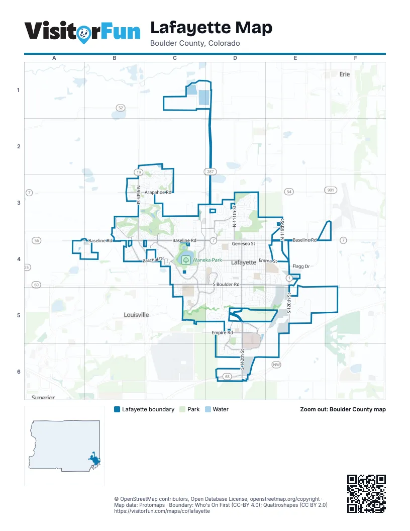
Street index of Lafayette
Each street on the sheet and the grid squares it crosses.
- Northwest ParkwayD6
- West Baseline RoadB4, C4, D4
- South 112th StreetD5, D6
- West South Boulder RoadC4, D4
- East Baseline RoadD4, E4, F4
- North 95th StreetB3, B4
- West Dillon RoadD6
- Arapahoe RoadB3, C3, D3
- Courtesy RoadB4, C4
- Flagg DriveE4
- Isabelle RoadD2
- East Baseline Road / State Highway 7F4
- East County Line RoadE4
- East South Boulder RoadD4, E4, E5
- Baseline RoadA4, B4
- South 120th StreetE4, E5
- South Public RoadD4, D5
- Empire RoadD5
- North 119th StreetE3, E4
- Coal Creek BoulevardE4
- Caria DriveC4
- Waneka Lake TrailC4
- Exempla CircleD5, D6
- North 111th StreetD3, D4
- Indian Peaks Trail WestB3, B4
- Centaur Village DriveC4, C5
- Paschal DriveB4, C4
- West Emma StreetC4, D4
- South Public DriveD5
- Aspen Ridge DriveC3, C4
- Crossing DriveD3, D4
- Autumn Ridge BoulevardD5, D6
- Minotaur CircleD4
- Minotaur DriveD4, C5, D5
- Cabrini DriveD3
- Roser DriveB4
- Indian Peaks DriveC4
- Diamond CircleC3, D3
- South Point DriveD6
- Campus DriveD6
- North Public RoadD4
- Angevine WayD4
- Indian Peaks TrailB3, C3, C4
- Horizon AvenueE5
- Whitetail CircleD5, D6
- Centaur CircleC5
- East Emma StreetD4, E4
- Ginny WayB2, C2, C3
- Spring Creek DriveC2, C3
- Merlin DriveD4, E4
- Avalon AvenueE4, D5, E5
- Old Laramie TrailD5
- Shoshone TrailB3, B4
- Lucerne DriveC3, D3
- Kimbark StreetD4
- Stagecoach DriveD5
- Hawk Ridge RoadD3
- Delphi DriveC4, D4
- Pioneer CircleD5
- East Chester StreetD4, E4
- Eagles Nest DriveC3, C4
- Sir Galahad DriveD4, E4
- East Cleveland StreetD4, E4
- Glenwood DriveD3
- West Lucerne DriveD3
- East Simpson StreetD4, E4
- East Geneseo StreetD4, E4
- South Carr AvenueD4
- South Longmont AvenueD4
- South Roosevelt AvenueD4
- Concord CircleB3, C3
- South Miller AvenueD4
- Old Wagon Trail CircleD5
- South Bermont AvenueD4
- Cimarron DriveC4, C5
- Lambert CircleC4
- Round Table DriveE4
- Mountain View DriveD6
- East Spaulding StreetD4, E4
- Galt WayB3, C3
- West Geneseo StreetD4
- Vetch CircleD3
- Acadia AvenueD3
- High Lonesome TrailC4
- Doric DriveC4
- Saratoga DriveD4, D5
- Thunder Lake CircleB3
- Casper DriveD5
- Sparta DriveC4
- Cantebury DriveE4
- Tennyson CircleE4, E5
- Zinnia CircleC3
- Zenith AvenueC4
- Lexington StreetB3, C3
- Atlantis AvenueC4
- Blue Lake TrailB3, B4
- West Spaulding StreetD4
- Nyland WayB4
- Westward DriveB3, C3
- Elk TrailD6
- Lake Meadow DriveB2, C2
- Arbor DriveD3, D4
- Starline AvenueD3
- Alexandria StreetD3
- Cheyenne DriveD5
- Lydia DriveC5
- Rock Creek CircleE5
- Lander LaneD4, D5
- Overlook DriveE5
- Blue Heron CircleB2, B3, C3
- Waneka ParkwayD4
- Anna Thomas ParkwayC4
- Harrison DriveD3
- Rendezvous DriveB4
- West Chester StreetD4
- Skylark CircleD4
- Dagny WayB3
- South Harrison CourtD4
- South Foote AvenueD4
- Blue Jay WayD6
- Viridan DriveD5
- Clover CircleD3
- Sandpiper DriveC4
- Bass CircleD3
- East Cannon StreetD4
- Ferguson CircleD5
- Wildridge LaneD3
- Shallot CircleD5, E5
- Mercator AvenueC4
- Miners DriveD4, D5
- Stein StreetD3
- Rock Ridge DriveD5
- South Harrison AvenueD4
- Arthur StreetE4
- Delta DriveD5
- Jackson StreetD5
- South Burlington AvenueE4
- Excalibur StreetD4, E4
- Cascade Creek DriveB4
- Cherokee TrailD5
- West Oak StreetD4
- Brittany LaneA4
- Mercury DriveD4
- Salina StreetC4
- Driftwood CircleC4
- Grand Lake DriveB4
- San Juan DriveD3
- North 96th StreetC4
- Euclid CircleC4
- Malory StreetD4, E4
- Blue Heron WayB2
- Etna DriveC4, C5
- Coal Creek DriveD4, D5
- West Cannon StreetD4
- West Cleveland StreetD4
- West Simpson StreetD4
- Red Deer TrailB3
- North Finch AvenueD4
- North Michigan AvenueD4
- London AvenueC4, D4
- North Iowa AvenueD4
- South Finch AvenueD4
- Birchwood CourtC2, C3
- North StreetD4
- Ceres DriveC4
- South Michigan AvenueD4
- South Gough AvenueD4
- Brainard CircleC3
- East Sutton CircleD4
- Sagrimore CircleE5
- City ParkD4
- Forest Park CircleC3
- South Cherrywood DriveD5
- Robin Hood StreetE4, D5, E5
- Warrior WayC5
- West Sutton CircleD4
- Caribou Pass CircleB4
- East Elm StreetD4
- Summit CircleD3
- Northpark DriveB3, C3
- South Bermont DriveD4
- North Bermont StreetD3, D4
- Sandler DriveD3
- Stage Station WayD5
- West Cannon PlaceD4
- Amelia LaneD3
- Columbine CircleB3, C3
- Cristo LaneD3
- Hillside TerraceC3
- Wellington AvenueD4
- Lavender Hill LaneC4
- Majestic DriveE5
- East Dounce StreetD4, E4
- Strathmore LaneD4
- Homestead StreetC3, C4
- Trails at Coal Creek DriveD5
- Golden Eagle CircleD6
- South Lafayette DriveD5, E5
- Lancelot StreetE4
- East Oak StreetD4
- City Center CircleD4
- Bitterroot CircleC3
- Gold Hill DriveC4
- Parkside CircleD5
- Bedivere CircleE5
- Ravenwood LaneB4, C4
- Sedge WayD3
- Courtney WayD5
- Black Diamond DriveD3, C4, D4
- Locksley StreetE5
- Crescent DriveD6
- Distel DriveE5
- Rawlins WayD5
- Cannon TrailD4, E4
- East Cherrywood DriveD5
- Beauprez AvenueB3
- Balmora StreetD3
- Alsace WayD3
- Milo CircleD4
- North Burlington AvenueE4
- South Iowa AvenueD4
- Lodgewood LaneB3, B4, C4
- Shadow Lake RoadB4
- Wilson StreetD3, D4
- Conoco PlazaD4
- Mills StreetC3, C4
- Snowbird LaneC3, C4
- Navajo TrailC3
- North Gough AvenueD4
- Cross Creek DriveB3
- Barberry AvenueD4
- Cypress CircleC4
- Crater Lake LaneB4
- Brown CourtD4, E4
- Marigold DriveD5
- Saint Ida CircleD4
- Cana CourtC3
- North Cherrywood DriveD5
- High Country TrailC4
- Clipper DriveC4
- West Cleveland CircleD4
- West Beacon Hill DriveD3
- West Cherrywood DriveD5
- Blue Stem TrailC3
- Zeus DriveC5
- Athene DriveC5
- Cordova CourtD3
- Northfield LaneC2, C3
- Ilium DriveC4
- Morning Star LaneC4
- Clear Creek LaneB4
- Niwot Ridge LaneC3
- Prairie Ridge DriveB3
- Bacchus DriveC5
- North Fork DriveC4
- Harvest DriveC3
- Perioval StreetE4, E5
- James CircleC5
- Puma DriveE4
- Cowley DriveB3, C3
- Dixon AvenueD4, D5
- Modred StreetE4
- Hoyt LaneB4
- Sweetwater CircleB4
- Sundown DriveD3
- Brooks AvenueD4
- Cardinal DriveD4
- Flamingo StreetD4
- Meadowlark DriveD4
- Dove DriveD4
- Bunting DriveD4
- Dannidan StreetE4, E5
- Westcliff DriveD3
- Cedarwood CircleD5
- Centaur Village CourtC5
- Rimrock CircleC4
- Skylark DriveD4
- Trail Ridge DriveC3
- Pinewood CircleD5
- Senecio CourtD3
- Edessa DriveC4, C5
- Autumn Ridge TrailD6
- West Brome AvenueD3
- Pheasant CircleD6
- Applewood DriveB4
- Dusty Boot DriveD5
- Guinivere StreetE4
- Parthenon CourtD4
- South Carole AvenueD4
- Acropolis DriveC4
- North Harrison AvenueD4
- Redwood AvenueD5
- Balmstone DriveD5
- BanneksD4
- Lost Creek LaneC3
- Tamarron LaneC4
- Artemis CircleD5
- Knight StreetE4
- Portside CourtC4
- Commerce CourtE5
Places on the map
- 1A Disabled
- Adler-Fingru Open Space
- Atlas Valley
- Black Diamond Shopping Center
- Blue Heron Park
- Bullhead Gulch Open Space
- Centaur Commons
- Centaurus High School
- Community Medical Center
- Cross Ridge Park
- FedEx Office
- Good Samaritan Medical Center
- Goose Haven Pit
- Goose Haven Reservoir
- Greenlee Wildlife Preserve
- Indian Peaks Golf Course
- Kneebone Open Space
- Lafayette City Park
- Lafayette Crossings
- Lafayette Elementary
- Lafayette Promenade
- LaMont Does Park
- Lionsgate Center
- Ofelia Miramontes Park
- Peak To Peak Charter School
- PostNet
- Rothman Open Space
- Sanchez Elementry
- The Great Bark Dog Park
- Thomas Open Space
- Walmart Supercenter
- Waneka Lake
- Waneka Lake Trail
- Waneka Landing Open Space
- Waneka Marketplace
- Waneka Park
- Whitetail Park
- Yarrow Park
Next to Lafayette
© OpenStreetMap contributors, Open Database License, openstreetmap.org/copyright · Map data: Protomaps · Boundary: Who's On First (CC-BY 4.0); Quattroshapes (CC BY 2.0)















