

Louisiana map
St. Martin Parish map
About 51,218 people live here (Census Bureau, 2024 estimate). The sheet's index lists 300 streets; Main Highway, Smede Highway and Old Spanish Trail Highway North cross the most grid squares. Things to do inside the boundary: Cajun Country Swamp Tours, Crawfish Town USA and Longfellow-Evangeline State Historic Site.
Open the map (PDF, US Letter)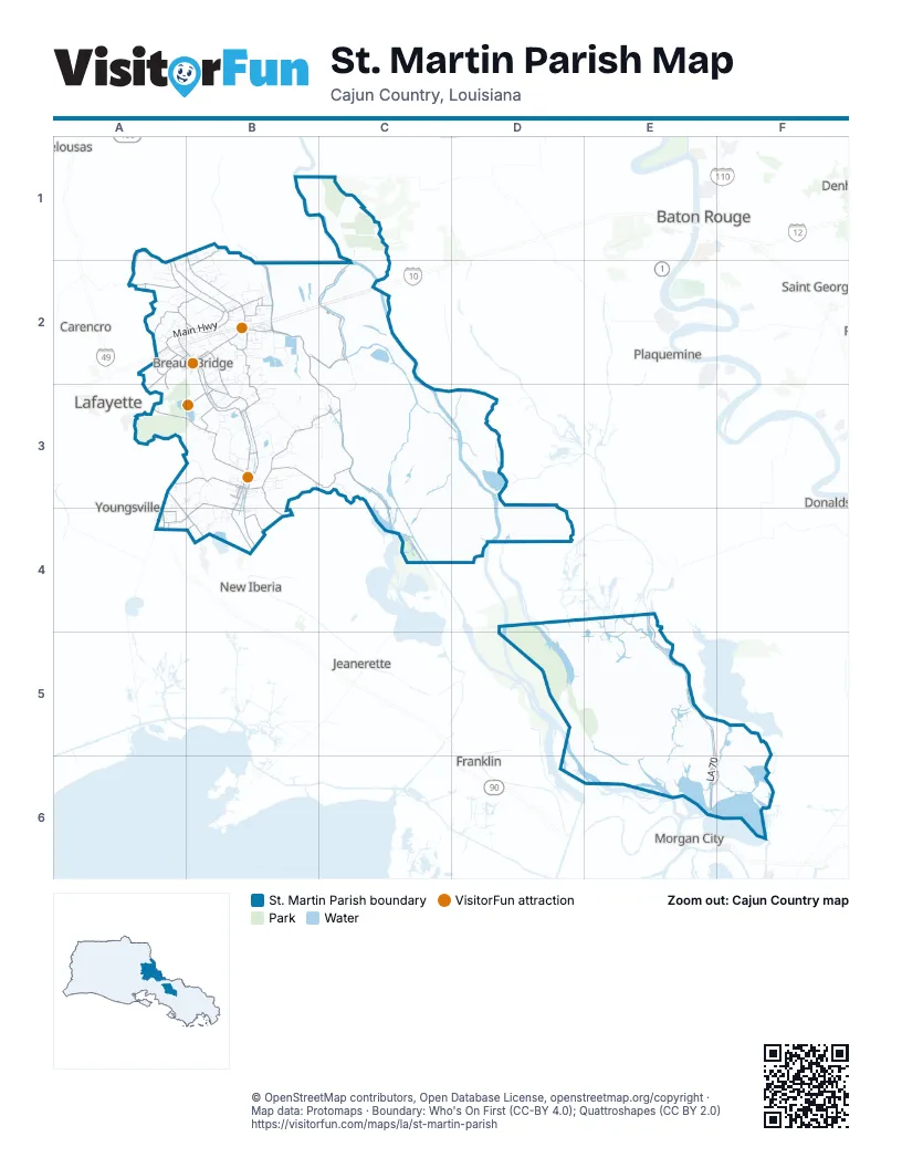
Street index of St. Martin Parish
Each street on the sheet and the grid squares it crosses.
- Atchafalaya Basin BridgeB2, C2
- Main HighwayA2, B2, B3, B4
- LA 70E5, E6
- Smede HighwayB3, A4, B4
- Anse Broussard HighwayA2, B2
- Veterans Memorial ExpresswayA4
- Old Spanish Trail Highway NorthA3, A4, B4
- Old Spanish Trail Highway SouthB4
- East Bridge StreetB2, B3
- Rees StreetA2, B2
- Rue Principale SudB3
- Martin StreetB2, B3
- Rue Principale NordB3
- Bridge StreetB3
- State Highway 70E5
- West Old Spanish TrailB4
- State Route 182B4
- Bayou Benoit Levee RoadC3, C4
- Catahoula HighwayB3, C3
- Cypress Island HighwayB3
- Henderson Levee RoadB2
- Grand Point HighwayB2
- Nursery HighwayB2, B3
- Sawmill HighwayA2
- Catahoula Levee RoadB2, B3, C3
- Levee HighwayE4, E5
- Terrace HighwayA3, B3
- State Route 347B2, B3
- Cemetery RoadB3, B4
- Prairie HighwayA3, B3
- Coteau Holmes HighwayB3
- West Mills AvenueA2, A3
- Resweber HighwayB3
- Bayou Alexandre HighwayB3, C3
- Bridge Street HighwayB3
- Burton Plantation HighwayB3, B4
- Levee RoadC4
- Nina HighwayB2
- Bayou Courtableau HighwayA1, A2
- Main StreetB2, B3
- Salt Mine HighwayA2
- Lake Martin RoadA3, B3
- Cecilia Senior High School HighwayB2
- Berard StreetA2, B2, B3
- West Bridge StreetB2, B3
- Henderson HighwayB2
- Ruth Bridge HighwayB3
- Neblet StreetA2
- Colonel Jeff de Blanc HighwayB3
- Allier Road, Chemin Metairie ParkwayA4
- South Poydras StreetB2
- East Mills AvenueA2, B2
- West Port StreetB3
- Port StreetB3
- Cecilia Bridge HighwayB2
- Brussard RoadC3
- State Route 345B4
- La 997E4
- Carmel AvenueA3
- State Route 31A2
- Coteau Holmes RoadB3
- Coteau Rodaire HighwayA1, B1, B2
- Atchafalaya River HighwayC2
- Bushville HighwayA1, A2, B2
- North Henderson Levee RoadB2
- Grand Anse HighwayB2
- Bayou Road SouthB2, C2
- McVeigh RoadA2
- Declouet HighwayA2, B2
- Doyle Melancon RoadB2, B3
- Herman Dupuis RoadB2, C2
- Hebert Ln HighwayB3
- Division RoadB1, B4
- North Portage HighwayB1, B2
- Loreauville HighwayB4
- Bayou Fuselier RoadA1, A2
- Hebert AvenueA2
- Petroleum ParkwayA4
- Bergeron RoadA2, A3
- Stephensville RoadE6, F6
- D'Augereaux RoadA2
- South Martin Luther King Jr DriveB3
- Captain Cade RoadB4
- Potato Shed RoadB2
- Governor Mouton StreetB3
- Canal StreetA1, B2, B3
- Saint Rita HighwayC3
- Landry DriveE6, F6
- Pont Brulie RoadA2
- East Refinery StreetB2
- Pontoon Bridge RoadF6
- Arnaudville RoadA2
- Four Mile Bayou RoadF5, F6
- Pellerin StreetB2
- Section 28 RoadB3
- Duchamp RoadA3, B3, A4
- Boon Lasseigne RoadB3
- Emile RoadB3, C3
- Banker RoadB3
- Grand Bois RoadB2, B3
- Lady of the Lake RoadB4
- Atchafalava River HighwayC2, C3
- Harold Stoutes RoadA2, B2
- Zin Zin RoadB2
- Rookery RoadA3, B3
- Ko Dupuis RoadB2
- Bayou Mercier RoadC3
- B B Senior High RoadB2
- Bayou Portage RoadC3
- Francis LoopB3
- Pine Alley DriveB3
- Spanish Lake RoadB4
- Tilac RoadA2
- George Dupuis RoadB2
- Durio RoadA2
- Lee Gordon RoadB2
- Regis Lagrange RoadB1, B2
- Roman Robin RoadB2
- Francois RoadB3
- True Friend RoadB3
- Raspy RoadB3
- Neg Lasseigne RoadB3
- Isle Labbe RoadB3
- Bayou Manuel RoadC1
- Moise Mallet RoadB2
- Joel Blanchard RoadB3
- North Barn RoadB2
- Johnson RoadB2
- Neuville Anthony RoadB4
- Camp Bon Temp RoadA2
- Russo Milazzo RoadB3
- Portage RoadB1
- Doyle Melancon ExtendedB2
- Rue de LaporteA2
- Ches Courville RoadB2
- St John Field RoadB3
- Gecko RoadA2
- Oliver DriveA2, B2
- Bordelon RoadB2
- Leed Champagne RoadB3
- Wilfred Champagne RoadB3
- Delcambre RoadB2
- Capritto RoadB3
- South Aubrey-Ozenne RoadB3
- Cormier RoadB2, B3
- Melvin Dupuis RoadB2
- Kidder-Robin RoadA2, B2
- Albert Leblanc RoadB3
- Huval RoadB2, B3
- La Freniere RoadB3
- Barras RoadB3
- Hollier RoadB2
- West J Bernard RoadB3, B4
- Clifton Angelle RoadB2
- Landing RoadC1
- Alcide Bonin RoadB2
- I- 10 Frontage HighwayB2
- Dermelie Calais Road EastB2
- Mike Leblanc RoadB2
- Gary DriveB2
- Old Henderson HighwayB2
- Joe Kidder RoadA1, A2
- Martin Dautreuil RoadB3
- State Route 736B3
- Chess Broussard RoadA2
- Chawee RoadB2, B3
- Latiolais DriveA2, B2
- Promenade IsadoreB3
- Ti-Adam Guidry RoadA2, B2
- Oak Harbor EstatesE6, F6
- Hope RoadB2
- Neg Albert RoadB3
- Papit Guidry RoadB3
- Huval LaneB2
- North Aubrey-Ozenne RoadB3
- Levert RoadB3
- Vieux Jacquet RoadA3, A4
- Courville RoadB2
- East Stephensville RoadF6
- Burdin Olivier RoadB1
- Wade O Martin RoadC3
- Auguillard RoadB2
- Bergeron Willow LaneA3
- Orphe Guidry RoadB2
- Will Angelle RoadB2
- Theobald RoadB3
- Patin RoadB2
- Rousseau Poche RoadB3
- Guidry RoadB2
- Ruth DriveB3
- Maurice RoadA4
- Lake Talon RoadA3
- Lion Castile RoadB2
- Fontelieu RoadB3
- Cecil Watkins RoadB2
- Steven Wiltz RoadB3
- Arnold RoadB2
- Angelle LaneB2
- Bergeron Rigs RoadA2
- Paul Joseph RoadB3
- Robert Mallet RoadB1, B2
- Bear Creek CircleA2, B2
- Delaloire RoadB3
- Belle Terre DriveB3
- Clovis Borel RoadB3, C3
- Grain Elevator RoadA2
- Chemin SieberB3
- Charles Marks RoadB1
- Earline DriveA2
- Clover Hill RoadB3, B4
- Carrier RoadB2
- Le Triomphe ParkwayA4
- Simon Angelle RoadA2, B2
- Berard Dumatrait RoadB2
- Madeline HeightsB2, B3
- South Parks DriveB3
- Wall RoadA4
- Lynn Hardy RoadB1
- Clayton Castille RoadB3
- Oleste Tauzin RoadA2
- Huron RoadB2
- Dean Leblanc RoadB2
- Edith-Tony DriveB2
- Commercial ParkA2, B2
- France-Palmire DriveB2
- Wild Cherry LaneB2
- Roy J Melancon RoadB2
- Latiolais LoopB2
- Mitt Naquin RoadB2
- Mitchell Boyer RoadB2
- Elliot DriveB3
- Begnaud RoadB1
- Lee Roy Bourque RoadA1, A2
- Alex Rouly RoadB3
- Betty DriveA2
- Granger RoadB4
- Sam Champagne RoadB2
- Orchard Park RoadB2
- T-Frere DriveB3
- La Monche RoadB3
- Leblanc DriveB2
- Degeyter RoadA2
- Armond Joseph RoadB2
- Choppy Cade RoadB3
- Parish Road 3-95C2
- U S L Experimental Farm RoadB4
- Olivier-Guidry RoadB1
- Jim Sells RoadB2
- Parkway RoadA2, B2
- Lena DriveA2, B2
- Olanda RoadB2
- Lawless Tauzin RoadA2
- Dupuis RoadB2
- Eunice RoadB3
- Donnell RoadA3
- Howard Broussard RoadB3
- Honey Comb DriveB4
- C Huval RoadB2
- Rue WashingtonB3
- South Theater StreetB3
- Girl Scout RoadA2
- Begnaud StreetA2, B2
- Martha Hebert RoadB2
- Fremin RoadA4
- Jules Broussard RoadA2
- Claston Simon RoadB2
- Albert RoadB3
- Cyrus DriveB3
- Kirk StreetB3
- Back Huval RoadB2
- Preston Guidry RoadB2
- Semere RoadB2
- Parish Road 201B3
- Bernis RoadB3
- Labit RoadA4
- Kennedy DriveB2
- High Pocket RoadB2, B3
- Mustang DriveB4
- Rue LedouxB3
- Rue ChurchB3
- Briarpatch RoadA4
- Huval StreetB2
- Broussard StreetA2, B2, B3
- North Martin Luther King Jr DriveB3
- Percey DriveB3
- Andrew DriveB3
- North Theater StreetB3
- St Charles StreetB2
- Jolie Blonde RoadB2
- Patin StreetB2
- Parker RoadB3
- Elm RunC2
- Eddie Ray RoadB2
- Hughes RoadA4
- Chevalier RoadB2
- Debra DriveA2
- R Babineaux RoadB4
- Rue LewisB3
- Hilda DriveA2
- Melrose DriveB2
Things to do on the St. Martin Parish map
Places on the map
- Ace Flying Airport
- Bordelon Airpark
- Breaux Bridge
- Brownell Memorial Park
- Camp Margaritaville Breaux Bridge
- Castille Field
- Catahoula Lake
- Cecilia
- Cecilia Post Office
- Cow Island Lake
- Cypress Island Reserve
- Deluxe Pull-Thru Campsites
- Dupuis Airport
- Eagle Ridge Golf Club
- Episcopal School of Acadiana Cade Campus
- Evangeline Canal
- Gary Landing Strip
- Genesis Behavioral Hospital
- Geralds Airstrip
- Grand Lake
- Grassy Lake
- Henderson
- Juneau Landing Strip
- Lake Fausse Pointe State Park
- Lake Martin
- Longfellow-Evangeline State Historic Site
- Louisiana Noname 45 Dam
- Louisiana Noname 49 Dam
- Magnolia City Park
- Park's Park
- Parks
- Pilot Travel Center
- Premium Pull-Thru Campsites
- Saint Martin Hospital
- Saint Martin Parish
- Saint Martinville City Hall
- Saint Martinville Post Office
- Skyview Ranch Airport
- St. Martinville
- Willow Lake
Next to St. Martin Parish
- Baton Rouge map
- Carencro map
- Donaldsonville
- Franklin
- Jeanerette
- Lafayette map
- Morgan City
- New Iberia map
- Opelousas map
- Patterson
- Plaquemine
- Saint George
- Youngsville map
© OpenStreetMap contributors, Open Database License, openstreetmap.org/copyright · Map data: Protomaps · Boundary: Who's On First (CC-BY 4.0); Quattroshapes (CC BY 2.0)















