

Massachusetts map
Plymouth map
About 66,663 people live here (Census Bureau, 2024 estimate). The sheet's index lists 300 streets; Pilgrim Highway, State Road and Federal Furnace Road cross the most grid squares. Things to do inside the boundary: Captain John Boats, Cole's Hill and National Monument to the Forefathers.
Open the map (PDF, US Letter)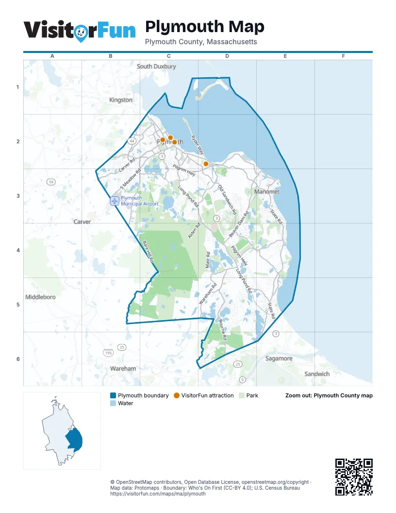
Street index of Plymouth
Each street on the sheet and the grid squares it crosses.
- Pilgrim HighwayB2, C2, C3, D3, D4, D5, E5
- Pilgrims HighwayC2, E5
- Carver RoadB2, C2, B3
- Samoset StreetC2
- State RoadD2, D3, E3, E4, E5
- Federal Furnace RoadB2, C2, B3, C3, B4
- Plimoth Patuxet HighwayD2, C3, D3
- Commerce WayB2
- Warren AvenueC2, D2
- South Meadow RoadB3
- Court StreetC1, C2
- Sandwich StreetC2, D2
- Herring Pond RoadE5, E6
- Summer StreetC2
- Cherry StreetB2, C2
- Plympton RoadB2
- Water StreetC2
- Nelson StreetC2
- Oak StreetC2
- Red Brook RoadD6
- Pilgrim Hill RoadC2
- Market StreetC2
- Leyden StreetC2
- Main Street ExtensionC2
- Parting Ways RoadB2
- Bishops HighwayB2
- Tremont StreetB4
- Long Pond RoadC3, D3, D4, D5, E5
- Old Sandwich RoadD3, D4, E4
- Bourne RoadD4, D5, D6
- Beaver Dam RoadD3, D4
- Ship Pond RoadD4, E4
- Wareham RoadD4, D5
- Rocky Hill RoadD2, D3, E3
- Halfway Pond RoadC4, D4
- Black Cat RoadB3, C3
- Billington StreetC2, C3
- Jordan RoadC3, D3
- South StreetC2, C3
- Hedges Pond RoadD5, E5
- Industrial Park RoadB2, C2
- Manomet Point RoadE3
- Westerly RoadC2
- Standish AvenueC2
- Ellisville RoadE4, E5
- Sandwich RoadD2, D3
- Clifford RoadD2, D3
- Obery StreetC2
- Taylor AvenueE3
- Camelot DriveC3
- White Horse RoadD3, E3
- Seven Hills RoadB2, C2
- River Run WayD5
- Nook RoadC2
- Liberty StreetC2
- Prestige WayB2
- Strand AvenueE3
- Clark RoadD4
- Hall StreetC2
- South Park AvenueC2
- Town WharfC2
- Plymouth StreetB3
- World WayB2
- Mcauliffe WayB2
- Town SquareC2
- Plymouth AvenueD5
- Plymouth LaneD6
- Lunn's WayD5
- Mast RoadD4
- Upper College Pond RoadC4, C5
- Bare Hill RoadC4
- Raymond RoadD5
- Indian Brook RoadE3, D4, E4
- Rocky Pond RoadC3, C4
- Lower College Pond RoadC4
- Little Sandy Pond RoadD5, D6
- Fearing Pond RoadC5
- Ryder WayC2, D2
- Long Ridge RoadD3
- Drew RoadC3
- Charge Pond RoadC5
- Center Hill RoadE4
- Alden RoadD3, C4, D4
- Bump Rock RoadD3, D4
- Circuit DriveC4, C5
- Bartlett RoadE3
- Colony PlaceB2
- Snake Hill RoadC3, C4
- West Long Pond RoadD4
- Mountain Hill RoadD5, E5
- Stonebridge RoadD3, D4
- Gunners Exchange RoadC3
- Pinewood RoadB3
- Esta RoadB2, B3
- DoublebrookD3
- Manomet AvenueE3
- Bournehurst DriveD6
- River StreetD2
- Power House RoadD2, D3
- Roxy Cahoon RoadD5, D6
- Lake View BoulevardD5
- Boot Pond RoadC3
- Fawn Pond RoadD4, D5
- Russell Mills RoadC3, D3
- Shops At 5 WayC3
- Sandy Beach RoadD5
- Watercourse PlaceC3
- Peter RoadB3
- College Pond RoadC3
- Oasis WayC2, C3
- Cutters Field RoadC5
- Little Pond RoadC2
- Barnfield DriveE4
- Island Pond RoadD3, E3, D4
- Dump RoadC3
- Lake DriveD6
- Valley RoadD5
- Martingale LaneD4
- Doten RoadD3
- Bay Shore DriveD2
- Fairview LaneD4
- White Cliffs DriveE5
- May Hill RoadC3
- Montgomery DriveB2, B3
- White Clover TrailD5
- Winslowe's ViewD3
- Pinehills DriveD4
- Great IslandD4
- Janebar CircleE5
- Nautical WayE4
- Brook RoadE3
- Jan Marie DriveB2, B3
- Agawam RoadD4, D5
- Widgeon Pond RoadC3, C4
- Nicks Rock RoadB2, C2
- Micajah Pond RoadB3, C3
- Village WayB3
- Fuller Farm RoadC3
- Sacrifice Rock RoadD3
- Kathleen DriveE3
- Scarlet DriveD5
- Bog Hill RoadD4, D5
- Newfield StreetC2
- Charlotte DriveB2
- Cooks Pond RoadC3
- Gallows Pond RoadD4
- North Triangle DriveB2, C2
- Crabtree RoadC3, D3
- Justine RoadD4, D5
- Forest EdgeD3, D4
- Dorothy DriveD4, D5
- Pine Mountain DriveE5
- Forges Field RoadD3
- Cemetery Hill RoadC3
- Kristin RoadB2
- Sanderson DriveE5
- Columbia CircleB2, B3
- Sea View DriveE3, E4
- Alewife RoadE5
- Morgan RoadD4
- Gunning Point RoadD5
- Brentwood CircleD3, E3
- Farm RoadD5
- Woody NookD3
- Shore DriveE4
- Armstrong RoadB2, C2
- Plimoth Plantation Access RoadD2
- Hog Rock RoadC3
- Ellisville DriveE3, E4
- Pilgrim TrailB2, C2
- Old Tavern TrailD3
- Town Brook RoadC2
- Allerton StreetC2
- Cranford RoadC4
- Peter Brown CartwayD3
- King Arthur RoadD1
- Stage Point RoadE3
- Joyce DriveD5
- Shallow Pond LaneE3
- Town Forest RoadC3
- Seton HighlandsD3
- Old Field RoadD3
- Hollis RoadD3
- Coles LaneC2
- Garrett PlaceD5
- Nathan LaneD5
- Cooke RoadC2
- Winthrop RoadE3
- RyecroftD3, D4
- Sterling BoulevardB2
- Southeast Line RoadC5
- Wall Wind DriveD5
- Knotty Pines RoadC3
- Lawrence RoadB3
- Cape Cod AvenueE3
- Buzzards Bay DriveD6
- Bradstreete CrossingD3
- Andrew's WayE3
- Clam PuddingD4
- Worrall RoadB2, B3
- Perseverance PathD5
- Howard DriveC3
- Little IslandD3, D4
- Island Lake RoadD5
- Braley LaneC2
- Lake RoadE4
- Treetop WayE5
- Tupper Hill RoadE5
- Trucker RoadD6
- Savery RoadD4
- Willow Bend BoulevardB2
- Wyndemere CourtB3, B4
- West Pond RoadB3
- Steeplebush WayC3
- Quail RunE4, E5
- Braley RoadC2
- Filmore StreetB2, B3
- Haven RoadD4
- Lisa AvenueB3
- Billington Sea RoadC2, C3
- Alden StreetC2
- Colony Village DriveB2
- Tower Hill Farm RoadD4
- Resnik RoadB2
- Canterbury DriveB3
- Great Woods RoadE4, E5
- Nickerson StreetD6
- Sixteen Twenty DriveB2, C2
- Powderhorn Pond RoadC3
- Wayfarer DriveB2, B3
- Dickson DriveD5
- Cypress StreetD6
- Winding WayC2, D2
- Lakewood DriveE5
- Cornish Field RoadD4
- Little Herring Pond RoadD5
- Maureen WayD4, D5
- Blueberry RoadD5
- Aldrin RoadC2
- South Triangle Pond RoadC3
- White Oak DriveC3
- Derek DriveE4
- Hillside DriveE4
- Pinehurst DriveB3
- Bettencourt RoadB3, C3
- Pawtuxet RoadE5
- Watercourse RoadC3
- Knoll RoadB3
- Bay Farm DriveD5
- Brigantine CircleE4
- Surrey DriveB2, B3
- Meeting WayD4
- Nathaniel StreetC2
- Bowsprit LaneD4
- Spencer DriveE5
- Early Red CircleE4
- Hood DriveB3
- Forge DriveD3
- Sunflower WayD5
- Symington DriveD4
- Amanda AvenueD5
- Jacqueline LaneB2, B3
- Pebble Beach DriveD4
- Pioneer TrailD5
- Lookout Point RoadE5
- West Cranford RoadC4
- Holbeck CornerD3
- Packard StreetD6
- Seagrass TrailD4
- Ellisville GreenE4
- Benjamin's GateD3
- Old Mans PathD6
- Reed AvenueE3
- Long Duck Pond RoadD5
- Red Maple LaneD5
- Nightingale RoadE5
- Wisteria RoadD5
- Dwight AvenueC2
- Colchester DriveC3
- Band DriveE3
- Lafayette RoadC3
- Casa Bella WayB2
- Tamarack RoadE5
- Lantern LaneB3
- Stone Gate DriveB2
- Herring WayD4
- Heather DriveE3
- Oar & Line RoadD4
- Haskell RoadD5, E5
- John Alden RoadD2, E2
- Arboretum RoadE3
- Hatherly RiseD3
- Henry DriveE3
- Flowery LaneD3
- Pond RoadB3, D5
- Carters Bridge RoadD5, E5
- Old Barn RoadC2
- Anawon RoadB2
- Kestrel HeightsD3
- Clark StreetC2, D4
Things to do on the Plymouth map
Places on the map
- Atlantic Country Club
- Besse Bog Reservoir
- Big Sandy Pond
- Billington Sea
- Black Cat Preserve
- Bloody Pond
- Boot Pond
- Briggs Property
- Cachalot Scout Reservation
- Camp (Harrison) Child
- Camp Norse
- Camp Wind In The Pines
- Center Hill Preserve
- Colony Place
- Crosswinds Golf Club
- Eel River Pond
- Eel River Preserve
- Ellisville Harbor
- Ellisville Harbor State Park
- Forge Field Property
- Forges Field
- Fresh Meadow Pond
- Fresh Pond
- Frogfoot Brook Reservoir
- Great Herring Pond
- Great Island Pond
- Great South Pond
- Halfway Pond
- Island Pond
- Little Herring Pond
- Little Island Pond
- Little South Pond
- Long Pond
- Manomet Recreation Area
- Morton Park
- Myles Standish State Forest
- Old Sandwich Golf Club
- Pinehills Golf Club
- Plymouth Municipal Airport
Next to Plymouth
- Carver
- Kingston
- Sagamore
- Sandwich
- South Duxbury
- South Middleboro
- Wareham
© OpenStreetMap contributors, Open Database License, openstreetmap.org/copyright · Map data: Protomaps · Boundary: Who's On First (CC-BY 4.0); U.S. Census Bureau