

New Hampshire road map
Connecticut River Byway map
The Connecticut River Byway has been a National Scenic Byway since 2009, named for its historic qualities: about 513 miles in New Hampshire, Vermont and Massachusetts. It meets 48 highways, among them I-89, I-91 and I-93. Towns along it: Northampton, South Hadley and Easthampton.
Open the map (PDF, US Letter)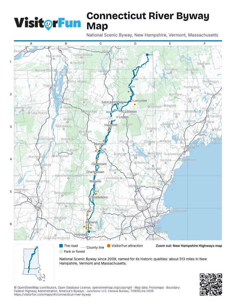
Highways it meets
Each highway it meets and the grid squares where they meet.
- MA 47C6
- MA 9C6
- MA 116C6
- MA 63C6
- MA 2C6
- MA 10C5
- NH 63C5
- NH 119C5
- NH 12C5
- US 5C5
- NH 12AC5
- NH 11C4
- VT 143C4
- VT 12C4
- VT 131C4
- VT 44AC4
- VT 44C4
- I-89C4
- US 4C4
- NH 10C4
- NH 120C4
- VT 132C4
- VT 113C3
- VT 244C3
- VT 25AC3
- I-91C3
- NH 25C3
- US 302C3
- NH 135C3
- NH 18D2
- I-93D3
- NH 142D2
- US 2D2
- VT 102D2
- US 3D2
- NH 26D1
- NH 145D1
- VT 26D1
- VT 18C2
- NH 116C3
- VT 25C3
- VT 14C4
- NH 103C4
- VT 11C4
- VT 103C5
- VT 9C5
- VT 119C5
- VT 142C5
Towns along the Connecticut River Byway
In mile order, with the grid square of each.
- South Hadleymile 0, C6
- Holyokemile 1, C6
- Hadleymile 3, C6
- Easthamptonmile 3, C6
- Northamptonmile 3, C6
- Hatfieldmile 9, C6
- Sunderlandmile 15, C6
- Whatelymile 16, C6
- South Deerfieldmile 19, C6
- Deerfieldmile 19, C6
- Montaguemile 23, C6
- Leverettmile 24, C6
- Millers Fallsmile 30, C6
- Ervingmile 31, C6
- Gillmile 32, C6
- Northfieldmile 33, C6
- Winchestermile 43, C5
- Hinsdalemile 44, C5
- Vernonmile 44, C5
- Chesterfieldmile 55, C5
- Westmorelandmile 62, C5
- Putneymile 66, C5
- Walpolemile 70, C5
- Westminstermile 72, C5
- North Westminstermile 78, C5
- Langdonmile 79, C5
- Bellows Fallsmile 80, C5
- Rockinghammile 80, C5
- North Walpolemile 80, C5
- Charlestownmile 82, C5
- Springfieldmile 89, C4
- Claremontmile 98, C4
- Weathersfieldmile 98, C4
- Ascutneymile 102, C4
- Windsormile 106, C4
- Cornishmile 106, C4
- Hartlandmile 113, C4
- Plainfieldmile 114, C4
- North Hartlandmile 120, C4
- Lebanonmile 122, C4
- Hartfordmile 122, C4
- White River Junctionmile 125, C4
- Hartford Villagemile 127, C4
- Wildermile 127, C4
- Hanovermile 130, C4
- Norwichmile 130, C4
- Thetfordmile 138, C4
- Lymemile 139, C3
- Fairleemile 148, C3
- Orfordmile 148, C3
- Bradfordmile 156, C3
- Piermontmile 157, C3
- Haverhillmile 162, C3
- Newburymile 163, C3
- North Haverhillmile 168, C3
- Woodsvillemile 173, C3
- Wells Rivermile 173, C3
- Bathmile 174, C3
- Ryegatemile 175, C3
- Monroemile 180, C3
- Barnetmile 183, C3
- Littletonmile 191, C2
- Waterfordmile 192, C2
- Concordmile 205, D2
- Daltonmile 210, D2
- Lunenburgmile 212, D2
- Lancastermile 217, D2
- Guildhallmile 222, D2
- Northumberlandmile 227, D2
- Maidstonemile 231, D2
- Stratfordmile 236, D2
- Brunswickmile 239, D2
- Bloomfieldmile 247, D2
- Columbiamile 250, D2
- Lemingtonmile 254, D2
- Colebrookmile 260, D1
- Canaanmile 262, D1
- Stewartstownmile 266, D1
- Clarksvillemile 271, D1
- Pittsburgmile 276, D1
- Beecher Fallsmile 307, D1
- West Stewartstownmile 311, D1
- Grovetonmile 331, D2
- Kirbymile 367, C2
- St. Johnsburymile 369, C2
- Dummerstonmile 492, C5
- Brattleboromile 498, C5
- Guilfordmile 504, C5
Things to do on the Connecticut River Byway map
- J. A. Skinner State Park
- Porter-Phelps-Huntington House
- Fort at Number 4
- American Precision Museum
- Saint-Gaudens National Historical Park
- Montshire Museum of Science
- King Arthur Baking Company
- Hood Museum of Art
- Farm-Way
- Bedell Bridge State Park
- Fairbanks Museum and Planetarium
- St. Johnsbury Athenaeum
- Beaver Brook Falls Wayside
© OpenStreetMap contributors, Open Database License, openstreetmap.org/copyright · Map data: Protomaps · Boundary: Federal Highway Administration, America's Byways · Junctions: U.S. Census Bureau, TIGER/Line 2026















