

New York map
Forest Park map
A printable two-page map of Forest Park (Queens, New York), drawn by VisitorFun from OpenStreetMap. Page two is the street index: every street on the sheet with its grid square, the same list as below.
Open the map (PDF, US Letter)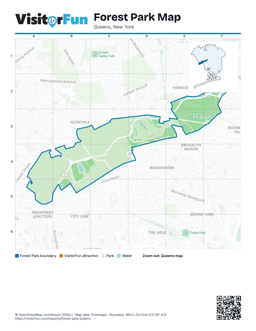
Street index of Forest Park
Each street on the sheet and the grid squares it crosses.
- 71st AvenueE2
- 72nd AvenueE2
- 72nd DriveE2
- Jackie Robinson ParkwayE2, F2, C3, D3, E3, B4, C4, A5, B5
- Union TurnpikeE2, F2, D3
- 80th RoadF2
- Forest Park DriveF2, D3, E3
- Greenway NorthF2
- Greenway SouthF2
- Grosvenor RoadF2
- Kessel StreetF2
- Markwood RoadF2
- Metropolitan AvenueF2
- Park LaneF2
- Park Lane SouthF2, D3, E3, F3, D4
- 68th StreetB3
- 78th AvenueB3
- Cooper AvenueB3, C3
- Cypress Hills StreetB3, B4, C4
- Wesley WayB3, C3, C4
- Bethel AvenueC3, D3
- Central AvenueC3, A4
- Cypress AvenueC3, B4, C4
- Gil MemorialC3
- Herzel AvenueC3
- Highland WayC3, C4
- Hope AvenueC3
- Jackie Robinson WayC3
- Jennings PlaceC3
- Lebanon AvenueC3
- Levy WayC3
- Lincoln AvenueC3, D3
- Machpela AvenueC3
- Maimonades AvenueC3
- Main RoadC3
- Memory RoadC3, C4
- Montefiore AvenueC3
- Paradise AvenueC3
- Sinai AvenueC3, D3
- Spinoza AvenueC3
- The PlazaC3
- Valley RoadC3, C4
- Washington AvenueC3, D3
- 80th StreetD3
- 81st AvenueD3
- 81st RoadD3
- 84th StreetD3
- 85th StreetD3
- 86th StreetD3
- 87th StreetD3
- 88th StreetD3
- Forest Park GreenwayD3
- Forest ParkwayD3
- Myrtle AvenueD3, E3, F3
- 104th StreetE3
- 89th StreetE3
- 90th StreetE3
- 91st StreetE3
- 98th StreetE3
- Freedom DriveE3
- Woodhaven BoulevardE3
- 112th StreetF3
- Highland BoulevardB4, C4, A5, B5, C5
- Highland Park GreenwayB4
- Vermont PlaceB4, B5
- Autumn AvenueC4
- Cypress RoadC4
- East DolorosaC4
- Hemlock StreetC4
- High Mountain RoadC4
- Highland Way IIC4
- Jamaica AvenueC4, D4, B5, C5
- Lake RoadC4
- Nichols AvenueC4
- ThanatopsisC4
- Thanatopsis SouthC4
- Veterans WayC4
- Via DolorosaC4
- West DolorosaC4
- William Miles WayC4
- Woodhull WayC4, D4
- 76th StreetD4
- 79th StreetD4
- 85th DriveD4
- 85th RoadD4
- Dexter CourtD4
- Eldert LaneD4
- Grant AvenueD4
- Fanchon PlaceA5
- Ashford StreetB5
- Cleveland StreetB5
- Elton StreetB5
- Essex StreetB5
- Linwood StreetB5
- Force Tube AvenueC5
- Highland PlaceC5
- Shepherd AvenueC5
Places on the map
- 1
- 2
- 3
- 4
- 5
- 6
- 7
- 75th Street-Elderts Lane
- 75th Street–Elderts Lane
- 9/11 Memorial Garden
- Beth Olom Cemetery
- Cemetery of the Evergreens
- Cypress Hills
- Cypress Hills Cemetery
- Cypress Hills National Cemetery
- Cypress Hills Street & Beth El Cemetery North
- Cypress Hills Street & Cypress Avenue
- Cypress Hills Street & Jamaica Avenue
- Cypress Hills Street & Machpelah Cemetery North
- Cypress Hills Street & Mount Neboh Cemetery
- Dawn of Glory
- DeVoy Playground
- Dolphin
- Forest Park
- Forest Park Bandshell
- Forest Park Barking Lot
- Forest Park Carousel
- Forest Park Golf Course
- Forest Park Shops
- Forest Park Soccer Field
- Forest Park Visitor Center
- Franklin K Lane High School
- Giovanelli Playground
- Greenhouse Playground
- Harry Houdini (Weiss)
- Highland Park
- Highland Park Community Garden
- Hungarian Cemetery
- Jackson Pond Playground
- Jamaica Avenue & Cleveland Street
Next to Forest Park
- Broadway Junction
- Brooklyn Manor
- City Line
- Cypress Hills
- Forest Hills
- Fresh Pond map
- Fresh Pond Junction
- Glendale
- Kew Gardens map
- Ozone Park map
- Parkside map
- Richmond Hill map
- The Hole
- Woodhaven map
© OpenStreetMap contributors (ODbL) · Map data: Protomaps · Boundary: Who's On First (CC-BY 4.0)