

New York map
John F. Kennedy International Airport District map
A printable two-page map of John F. Kennedy International Airport District (Queens, New York), drawn by VisitorFun from OpenStreetMap. Page two is the street index: every street on the sheet with its grid square, the same list as below.
Open the map (PDF, US Letter)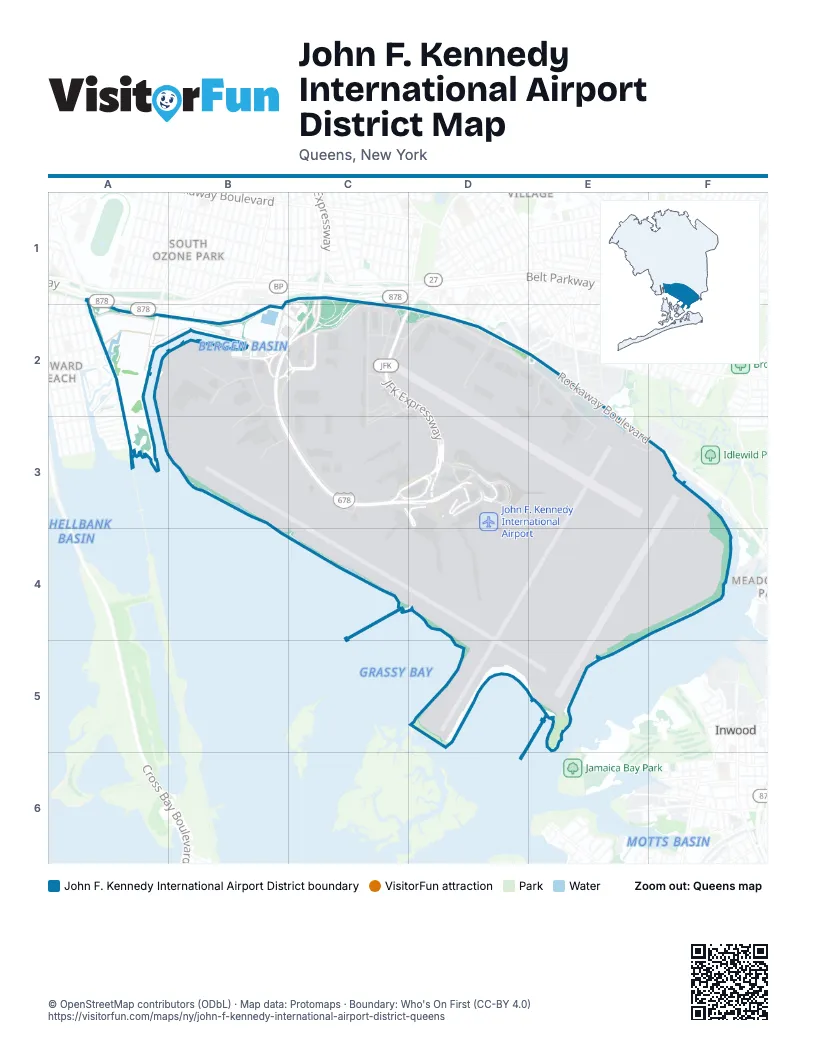
Street index of John F. Kennedy International Airport District
Each street on the sheet and the grid squares it crosses.
- Aqueduct RoadA1, A2
- Nassau ExpresswayB1, C1, B2, C2, D2
- Lefferts BoulevardA2
- Pan Am RoadA2, B2
- 130th PlaceB2
- 134th StreetB2
- 150th AvenueB2, C2
- 155th AvenueB2
- Bergen RoadB2
- Cargo 21B2, C2, C3
- Cargo Service RoadB2, C2
- Commissary RoadB2
- East Hangar RoadB2, B3
- Federal CircleB2, C2
- Hangar 10B2, C2
- North Service RoadB2, C2, B3, C3
- Seaboard WayB2, C2
- South Service RoadB2, B3, C3
- Van Wyck ExpresswayB2, C2, B3, C3, D3
- West Hangar RoadB2
- 147th AvenueC2
- 147th StreetC2
- 148th StreetC2, D2
- 150th StreetC2
- Cargo PlazaC2
- Cargo Plaza RoadC2, C3
- Center Cargo RoadC2
- Compass RoadC2
- Federal Circle PickupC2
- Federal Circle Pickup AreaC2
- JFK ExpresswayC2, D2, D3
- North Boundary RoadC2, D2, E2
- North Service CourtC2
- Pilot RoadC2
- Rental Car NorthC2
- Rental Car SouthC2
- South Cargo RoadC2, D2, C3
- South Service CourtC2, C3
- Farmers BoulevardD2, E2
- North Hangar RoadD2
- Rockaway BoulevardD2, E2, E3, F3
- Eastern RoadE2, E3, F3
- Old Rockaway BoulevardE2
- General Aviation LayneB3
- JFK Access RoadC3, D3
- Terminal 1 ArrivalsC3, D3
- Terminal 1 DeparturesC3, D3
- Terminal 8 ArrivalsC3, D3
- Terminal 8 DeparturesC3, D3
- Idlewild DriveD3
- Terminal 4 DeparturesD3
- Terminal 5 ArrivalsD3
- Terminal 5 DeparturesD3
- Terminal 7 ArrivalsD3
- Terminal 7 DeparturesD3
- Terminal 7 ParkingD3
Places on the map
- 17
- 19
- 262 Federal Express
- AAL
- Allied Aviation Fuel
- Allied Aviation Tank Farm
- ANA
- Blue Parking
- Blue Parking Garage
- Building 81 Parking
- Cargo
- Cell Phone Lot East
- DAL
- DHL Cargo
- Enterprise
- FedEx
- Fire Fighting Training Area
- General Aviation
- HELIPAD
- JetBlue
- JFK Airport Employee Parking
- JFK Cell Phone Waiting Lot West
- JFK Central Taxi Hold
- JFK Long Term Parking Area A
- JFK Long Term Parking Area B
- JFK Long Term Parking Area C
- JFK New T1
- JFK Terminal 6
- John F. Kennedy International Airport
- KAL
- Kennedy International Airport Cogen
- New Terminal 1
- New York City Police Department Pound
- NYC Police Department Impound Parking
- Orange Parking Garage
- Queens County
- Red Parking Garage
- Rental Car South
- SIXT Rent a Car JFK Car Rental
- SQ
Next to John F. Kennedy International Airport District
© OpenStreetMap contributors (ODbL) · Map data: Protomaps · Boundary: Who's On First (CC-BY 4.0)