

New York map
Riverhead map
About 36,067 people live here (Census Bureau, 2024 estimate). The sheet's index lists 300 streets; Sound Avenue, Third Street and Second Street cross the most grid squares. Things to do inside the boundary: Calverton National Cemetery, Long Island Aquarium and Exhibition Center and Suffolk County Historical Society.
Open the map (PDF, US Letter)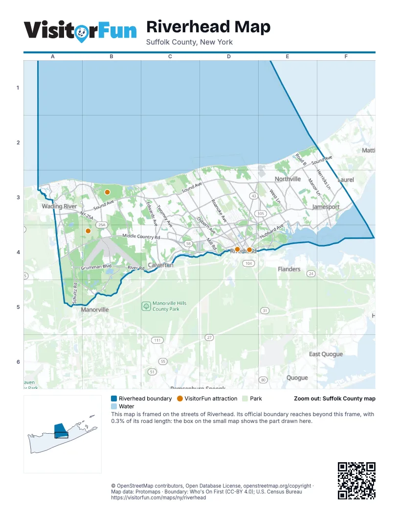
Street index of Riverhead
Each street on the sheet and the grid squares it crosses.
- Long Island ExpresswayC4
- Sound AvenueE2, F2, A3, B3, C3, D3, E3
- Cross River DriveD3, E3, E4
- Middle Country RoadA4, B4, C4
- Route 25E3, F3, C4
- Old Country RoadD3, C4, D4
- West Main StreetC4, D4
- Northville TurnpikeD3, D4
- NY-25AA3, B3, B4
- East Main StreetD3, D4
- Tanger Mall DriveC4
- Main RoadD3, E3, F3
- Peconic AvenueD4
- Center Drive SpurD4
- Route 25AA3
- Wading River Manor RoadA3, A4, A5, B5
- Roanoke AvenueC2, C3, D3, D4
- Edwards AvenueB3, C3, C4
- Hulse Landing RoadB3, B4
- North Country RoadA3
- Schultz RoadA4, A5
- Wildwood Park RoadB3
- River RoadB4, C4, B5
- Osborn AvenueC3, D3, D4
- Middle RoadD3, C4, D4
- Peconic Bay BoulevardE3, F3, E4
- Doctors PathD3
- Reeves AvenueC3, D3
- Twomey AvenueC3, C4
- North Wading River RoadA3, B3
- Grumman BoulevardA4, B4
- Manor LaneE2, E3, F3
- Horton AvenueC3, D3, D4
- West LaneA3, E3
- Mill RoadC3, D4
- Herricks LaneE2, F2, F3
- Fresh Pond AvenueB3, B4
- Pulaski StreetD4
- Hubbard AvenueE3, D4, E4
- Church LaneE3
- Burman BoulevardB4
- Ostrander AvenueD3, D4
- Tuthills LaneE3
- Union AvenueE3, D4
- Youngs AvenueC3
- Riverside DriveD4, E4
- Deep Hole RoadC3, C4
- Manor RoadC4
- South Jamesport AvenueF3, F4
- Laurel LaneA3, B3, F3
- Riley AvenueC3, C4
- Elton StreetD4
- Harrison AvenueD4
- Phillips LaneE3
- Fairway DriveA3, B3
- Sound RoadA3
- Creek RoadA3, E4
- Meeting House Creek RoadE3, E4
- Long Pond RoadA3, A4
- Forge RoadC4
- Kroemer AvenueC4
- Edgar AvenueE3
- Griffing AvenueD4
- Fairway AvenueB3, D4, E4
- Connecticut AvenueB4
- Court StreetD4
- Debbie LaneA3
- Foxwood VillageC4, D4
- Calverton DriveB3, A4, B4
- Sound Shore RoadD2, E2
- Indian Point RoadE4
- AldersgateD3
- Hidden Acres PathA4
- Oakleigh AvenueC3
- Overlook DriveA3, E3, E4
- North Side RoadA3
- Remsen RoadA3
- Line RoadB4, B5
- Pennys RoadD2, D3, E3
- Old River RoadB5
- Golden Spruce DriveC3, C4
- Princeton BoulevardB4
- Road BE2
- Hulse AvenueB3, E4
- Oak DriveB3, D3, F3
- Theodore Roosevelt RoadA4, B4
- Pier AvenueE2
- Stoneleigh DriveD3
- Hartmann's Farm RoadD3
- Pebble Beach PathD3
- Washington AvenueF3
- Stonecrop RoadE3
- North Woods DriveA3
- Beach RoadA3, F3, E4
- Southfield RoadC3
- Williams Way SouthC3
- Raynor AvenueD4
- Rabbit RunD3
- Oakwood DriveA3, B5
- Third StreetB3, C3, F3, C4, D4, E4
- Scott AvenueB4
- Old Farm RoadD3
- Baywood DriveC3
- Second StreetB3, C3, F3, C4, E4, F4
- Warner DriveC3
- Shade Tree LaneE3, E4
- Alexander Hamilton RoadB4
- Veterans CircleA4, B4
- Park RoadC3
- Great Rock DriveA3
- Hidden Pond PathA4
- Grant DriveE3
- Dolphin WayD2, D3
- Sylvan DriveA3, B3
- Calverton CourtA4
- 22nd StreetB3
- Arrowhead AvenueD3
- Marcy AvenueD4
- Terry Farm RoadC3
- Tyler DriveD3
- Little Flower DriveA3
- Garfield Langhorn RoadB3, B4
- Fox Hill DriveC3
- Michaels LaneA4
- Sweezy AvenueD4
- Col. Francis S. Gabreski WayB3, B4
- First StreetB3, C3, C4, D4, E4
- Dog Wood DriveA3
- OakwoodD4
- Willow Pond RoadD3
- Trout Brook LaneE3, E4
- South PathB4
- Landing LaneB3, C3
- Saddle Lakes DriveD3
- Molly Pitcher RoadA3, B3, A4
- Maidstone LaneA4
- Donna DriveC3
- Linda AvenueE3, E4
- Ellen StreetD3
- Cliff Road WestA3
- Kings DriveD4
- May DriveC3, C4
- Oliver StreetA3, D4
- Sunset BoulevardA3
- Riverhead LandingD4
- Circle DriveF3, E4
- Railroad AvenueC4, D4
- Baiting Hollow LaneC3
- Meadow PathA3
- Roger Williams RoadA3
- Williams Way NorthC3
- High Meadow LaneF3
- South RoadA3
- Crystal DriveE3
- Eight Bells RoadC3
- Farm Road SouthA3
- Fourth StreetB3, C3, F3, C4
- Hill StreetA3, B3, C4
- Broad AvenueE3, E4
- North Griffing AvenueD4
- CirclewoodD4
- Mastro RoadC3
- Stephen DriveA4
- Sun Up TrailE3, E4
- Southfields RoadE3
- Bayberry RoadA3
- Maple RoadA3, B3
- Herod Point RoadA3
- Vineyard WayE3
- Canterbury DriveA4
- Deer RunA3
- Old Orchard RoadA3, C3
- Center StreetF3, F4
- Parkway StreetD4
- Farm Road EastA3
- Hamilton AvenueD4
- Fishel AvenueD4
- Jan WayB4
- Jacobs PlaceE4
- Witt LaneE3
- Farm Road WestA3
- Peconic River VillageC4
- Jakes LaneC4
- East StreetC3, F3, F4
- Splish Splash DriveC4
- Cedar RoadB3
- Howell AvenueD4
- Gregory WayB3
- John Jay RoadB4
- Vista CourtF3
- GlynwoodD4
- Fire LaneB3
- Fox Run LaneE4
- Tuts LaneF3
- Linda Lane WestC3, D3
- North Woods RoadC3, C4
- Scenic Lake DriveD3
- WindwoodD4
- Amen CornerD3
- Founders PathB3, C3
- Lincoln StreetD4
- Josephine DriveA4
- Sunrise AvenueD4, E4
- PondwoodD4
- Maple Wood LaneE4
- St. Marys DriveF3
- Industrial BoulevardD4
- FarwoodD4
- J.T. BoulevardD4
- Gerald StreetA3, B3, A4
- Louise CourtD3
- West Woodland DriveA3
- High View DriveA3
- Mastro CourtC3
- River AvenueE4
- East Second StreetD4
- Promenade DriveE3
- Point StreetF3, F4
- Woodcrest AvenueD4
- East Woodland DriveA3
- Timothy LaneF3
- Nadel DriveD3
- Linda Lane EastC3, D3
- Colonial DriveE3
- Dredging Pond RoadE4
- Constable DriveD3
- Long View DriveA3
- Emmetts LaneA3
- Heidi Behr WayD4
- Willow StreetF3, E4, F4
- Merritt's Pond RoadD4
- East Meadow RoadC3
- Overhill RoadA3
- Northgate CircleC3
- Newton AvenueD4
- Park AvenueC4, D4
- Dogwood LaneA3
- Further LaneE4
- East AvenueD4
- Eileen CircleF3
- Daly DriveE4
- Silver Beech LaneB3
- The PreserveC3
- LeafwoodD4
- Bluff Drive NorthC3
- Fifth AvenueB3
- Triangle LaneC4
- Broad View CircleA3
- Soundbreeze TrailA3
- Fourth AvenueB3
- Timber DriveB4
- Merion CircleA4
- Green StreetF3, F4
- Hallock StreetD4
- Maple AvenueD4
- Cliff RoadB3
- Columbus AvenueD4
- 20th StreetB3
- Goose Neck LaneD3
- Moet DriveD3
- Lockitt DriveF3, F4
- 19th StreetB3
- Ackerly StreetD4
- Ida LaneE3
- Crescent CourtA3
- Hidden Pheasant PathA4
- Segal AvenueD4
- 18th StreetB3
- Alfred AvenueC3
- Clover PlaceE3
- 6th StreetB3, F3
- 17th StreetB3
- Meadow LaneE4
- 16th StreetB3
- 15th StreetB3
- North RoadA3, B3
- Roanoke CourtD3
- Leafy WayE4
- Josica LaneE3
- Nicholas WayC4
- Bokinzal RoadE4
- Indian Landing RoadE4
- 21st StreetB3
- West StreetF3, D4, F4
- North Railroad AvenueF3
- Karlin DriveC3, C4
- 3rdD4
- Laurel Hollow CourtA3, B3
- Sandalwood LaneE4
- Barnes RoadA3, A4
- Little Bay RoadA3
- Iroquois WayA4, B4
- South Railroad AvenueF3
- East LaneA3
- Forest DriveE3, E4
- Locust RoadB3
- Cliff WayB3
- Front StreetA3, F4
- Meroke TrailA4
- Corwin StreetD4
Things to do on the Riverhead map
Places on the map
- 877/905 East Main Office Park
- Aquebogue
- Baiting Hallow Golf Club
- Baiting Hollow
- Calverton
- Calverton Mountain Bike Trail
- Calverton National Cemetery
- Calverton Pine Barrens State Forest
- Calverton Ponds Preserve
- Canoe Lake
- Deep Pond
- Downtown Riverhead
- Friar's Head
- Grassy Pond
- Hallock State Park Preserve
- Harvest Hill Nursery
- Indian Island County Park
- Indian Island Golf Course
- Jamesport
- John M. Schiff Scout Reservation
- Linus Pond
- Long Island National
- Merritts Pond
- Miamogue Lagoon
- Northville
- Otis Pike Preserve - Fresh Pond
- Otis Pike Preserve - West
- Peasys Pond
- Peconic Bay Medical Center
- Peconic Estuary
- Prestons Pond
- Riverhead Centre
- Riverhead High School
- Robert Cushman Murphy County Park
- Splish Splash Water Park
- Swan Lake Golf Club
- The Rock Golf Club
- Wading River
- Wildwood State Park
- Wildwood State Park Campground
Next to Riverhead
- East Quogue
- Flanders
- Laurel
- Manorville
- Mattituck
- Quogue
© OpenStreetMap contributors, Open Database License, openstreetmap.org/copyright · Map data: Protomaps · Boundary: Who's On First (CC-BY 4.0); U.S. Census Bureau















