

New York map
Rockland County map
About 348,144 people live here (Census Bureau, 2024 estimate). The sheet's index lists 65 streets; Palisades Interstate Parkway, New York State Thruway and Seven Lakes Drive cross the most grid squares. Things to do inside the boundary: Palisades Center.
Open the map (PDF, US Letter)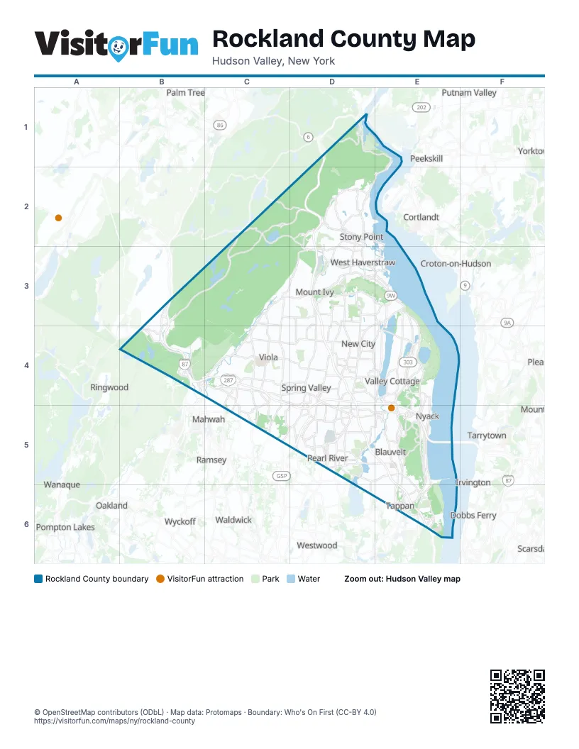
Street index of Rockland County
Each street on the sheet and the grid squares it crosses.
- Bear Mountain BridgeD1
- Palisades Interstate ParkwayD1, D2, D3, D4, D5, E5, E6
- Seven Lakes DriveC2, B3, C3, B4
- Central DriveD2
- Gate Hill RoadD2
- North Liberty DriveD2, E2
- South Liberty DriveD2, D3
- New York State ThruwayB3, B4, C4, D4, E4, D5, E5
- Orange TurnpikeB3, B4
- Haverstraw RoadC3, C4
- Route 202C3, D3
- State Highway 306C3, C4
- Conger AvenueD3, E3
- Gurnee AvenueD3
- Ramapo RoadD3
- State Highway 45D3, D4
- US 202D3
- West Ramapo RoadD3
- Westside AvenueD3
- North Route 303E3, E4
- State Highway 304E3, D4, D5
- Lafayette AvenueB4, C4
- Old Route 17B4
- Orange AvenueB4
- Sterling Mine RoadB4
- Wayne AvenueB4, C4
- Alturas RoadC4, D4
- Main StreetC4, E6
- New York State Highway 59C4
- Saddle River RoadC4, C5
- State Highway 59C4
- State Route 59C4
- Chestnut Ridge RoadD4, C5, D5
- East Central AvenueD4
- North Main StreetD4
- South Main StreetD4
- North Highland AvenueE4, E5
- State Highway 303E4
- State Highway 303 NorthE4
- State Highway 303 SouthE4
- Blue Hill Road SouthD5
- Garden State ParkwayD5
- Garden State Parkway ConnectorD5
- North Kinderkamack RoadD5
- North Pearl StreetD5
- Orangeburg RoadD5, E5, E6
- South Pearl StreetD5
- Veterans Memorial DriveD5
- Bobby LaneE5
- High AvenueE5
- Highland AvenueE5, E6
- Hillside AvenueE5
- Mountainview AvenueE5
- Palisades Center DriveE5
- South Highland AvenueE5
- State Highway 340E5, E6
- Orangeburgh RoadD6
- Livingston StreetE6
- Old Tappan RoadE6
- Palisades BoulevardE6
- Piermont RoadE6
- Route 9WE6
- Union StreetE6
- Valentine AvenueE6
- Washington StreetE6
Things to do on the Rockland County map
Places on the map
- Ba Mar Mobile Homes
- Bardonia
- Bear Mountain State Park
- Blauvelt
- Blauvelt State Park
- Blue Hill Golf Course
- Blue Hill Plaza
- Blueberry Commons
- Bowline Point Power Plant
- Breakneck Pond
- Broadacres Golf Club
- Bulsontown Lake
- Camp Ramaquois
- Cedar Pond Brook
- Central Nyack
- Cheesecote Mountain Park
- Clarkstown North High School
- Clover Stadium
- Congers
- Congers Lake
- Cranberry Pond
- Cropsey Community Farm
- Davenport Preserve
- Dellwood Country Club
- Demarest Kill County Park
- Eagle Ridge Way
- Gate Hill Day Camp
- Germonds Park
- Good Samaritan Hospital
- Green Swamp
- Haverstraw Beach State Park
- Haverstraw Quarry
- Helen Hayes Hospital
- Hessian Lake
- High Tor State Park
- Highlands Nanuet Apartments
- Hillburn Yard
- Hillcrest
- Hook Mountain State Park
- Iona Island Estuarine Research Reserve
Next to Rockland County
- Briarcliff Manor
- Cortlandt
- Croton-on-Hudson
- Dobbs Ferry
- Irvington
- Mahwah
- Oakland
- Palm Tree
- Peekskill
- Pompton Lakes
- Putnam Valley
- Ramsey
- Ringwood
- Scarsdale
- Sleepy Hollow
- Tarrytown
- Waldwick
- Wanaque
- Westwood
- Wyckoff
- Yorktown
© OpenStreetMap contributors (ODbL) · Map data: Protomaps · Boundary: Who's On First (CC-BY 4.0)