

Ohio map
Cincinnati map
About 314,915 people live here (Census Bureau, 2024 estimate). The sheet's index lists 125 streets; River Road, Mill Creek Expressway and Vine Street cross the most grid squares. Things to do inside the boundary: American Sign Museum, Cincinnati Art Museum and Cincinnati Museum Center.
Open the map (PDF, US Letter)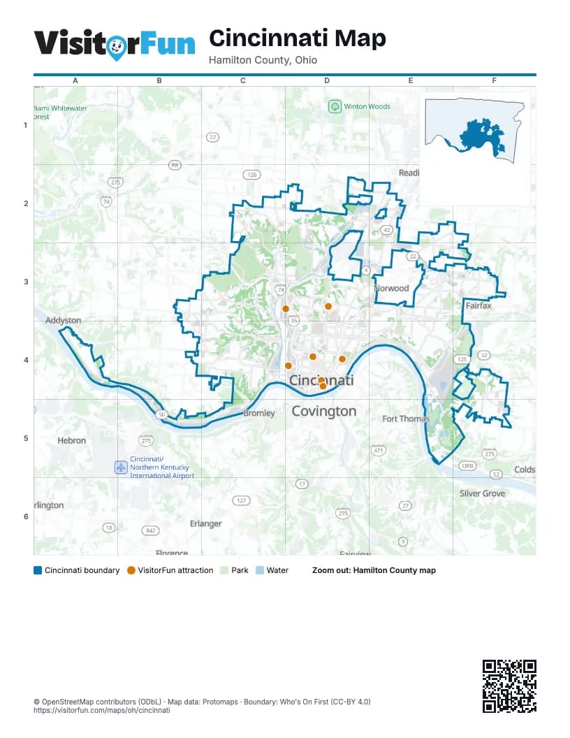
Street index of Cincinnati
Each street on the sheet and the grid squares it crosses.
- Colerain AvenueC2, C3
- Hamilton AvenueC2, C3, D3
- West North Bend RoadC2, D2
- Center Hill AvenueD2
- East Seymour AvenueD2, E2, E3
- Mill Creek ExpresswayD2, E2, D3, D4
- Ronald Reagan Cross County HighwayD2, E2
- Towne StreetD2
- Vine StreetD2, E2, D3, D4
- West Galbraith RoadD2, E2
- Winton RoadD2, D3
- East Galbraith RoadE2
- Montgomery RoadE2, E3
- Paddock RoadE2, D3
- Reading RoadE2, D3, E3, D4
- Ridge RoadE2, E3
- Seymour AvenueE2
- Glenway AvenueB3, B4, C4
- Queen City AvenueB3, B4, C4
- Werk RoadB3
- Beekman StreetC3, C4
- Elmore StreetC3
- Harrison AvenueC3, C4
- Hopple StreetC3, D3
- Hopple Street ViaductC3
- Northwest ExpresswayC3
- Spring Grove AvenueC3, D3, C4, D4
- Westwood Northern BoulevardC3
- William P. Dooley BypassC3, D3
- Central ParkwayD3, D4
- Clifton AvenueD3, D4
- Gilbert AvenueD3, E3, D4
- Ludlow AvenueD3
- Ludlow ViaductD3
- Northeast ExpresswayD3, E3, D4
- Norwood Lateral ExpresswayD3, E3
- West Martin Luther King Junior DriveD3, D4
- West Mitchell AvenueD3
- Alamo AvenueE3
- Duck Creek RoadE3
- Edwards RoadE3
- Linwood AvenueE3, E4
- Madison RoadE3, F3, D4, E4
- Mill Ridge RoadE3
- Observatory AvenueE3
- Ridge AvenueE3
- Camargo PikeF3
- Plainville RoadF3
- Red Bank ExpresswayF3
- Red Bank RoadF3
- River RoadA4, B4, C4, B5, C5
- Three Rivers ParkwayA4
- Queen City BypassC4
- State AvenueC4
- Warsaw AvenueC4
- West 6th StreetC4, D4
- West 8th StreetC4, D4
- Western Hills ViaductC4
- Western Hills Viaduct (Lower Deck)C4, D4
- Western Hills Viaduct (Upper Deck)C4, D4
- Westwood AvenueC4
- Wilder AvenueC4
- 7th Street ViaductD4
- Auburn AvenueD4
- Bains StreetD4
- Barry Larkin WayD4
- Broadway StreetD4
- Calhoun StreetD4
- Central AvenueD4
- Clay Wade Bailey BridgeD4
- Columbia ParkwayD4, E4, F4
- Dalton AvenueD4
- East 2nd StreetD4
- East 3rd StreetD4
- East 5th StreetD4
- East 7th StreetD4
- East 8th StreetD4
- East 9th StreetD4
- East Central ParkwayD4
- East Liberty StreetD4
- East Martin Luther King Junior DriveD4
- East McMillan StreetD4
- East Mehring WayD4
- East Pete Rose WayD4
- East Ted Berry WayD4
- Eggleston AvenueD4
- Elm StreetD4
- Elsinore PlaceD4
- Ezzard Charles DriveD4
- Fort Washington WayD4
- Freeman AvenueD4
- Gest StreetD4
- Gilbert Avenue ViaductD4
- Jefferson AvenueD4
- John A. Roebling Suspension BridgeD4
- Linn StreetD4
- Lytle TunnelD4
- Main StreetD4
- Marian Spencer WayD4
- Plum StreetD4
- Riverside DriveD4, E4
- Rosa Parks StreetD4
- Sycamore StreetD4
- Taylor Southgate BridgeD4
- Taylor–Southgate BridgeD4
- Walnut StreetD4
- West 2nd StreetD4
- West 3rd StreetD4
- West 7th StreetD4
- West 9th StreetD4
- West Central ParkwayD4
- West Clifton AvenueD4
- West Liberty StreetD4
- West McMillan AvenueD4
- West Mehring WayD4
- West Pete Rose WayD4
- Western AvenueD4
- William Howard Taft RoadD4
- William L. Mallory, Sr. StreetD4
- Winchell AvenueD4
- Beechmont AvenueE4, F4, F5
- Delta AvenueE4
- Eastern AvenueE4, F4
- Kellogg AvenueE4, E5
- Circle FreewayE5
Things to do on the Cincinnati map
Places on the map
- Aiken High School
- Alms Park
- Armleder Dog Park
- Armleder Trail
- Aronoff Center for the Arts
- Ault Park
- Avon Field
- Avondale
- Badgley Run Park
- Baltimore Pike Cemetery
- Bond Hill
- Bortz Family Nature Preserve
- Bortz Gravel Trail
- Bradford-Felter Tanglewood Preserve
- Brookstone Village
- Burnet Woods
- Byer Steel
- Caldwell Preserve
- California
- California Golf Course
- California Woods Nature Preserve
- Camp Washington
- Carew Tower
- Carthage Neighborhood Business District
- Centennial Station
- Central Business District
- Cincinnati
- Cincinnati Country Club
- Cincinnati Milacron
- Cincinnati Union Terminal
- City West Apartments
- Clifton
- Clifton Business District
- Clifton Heights–University Heights–Fairview
- College Hill Business District
- Columbia Tusculum
- Corryville
- Daniel Drake Park
- Deer Hill
- Derrick Company
Next to Cincinnati
- Addyston
- Arlington Heights
- Bellevue
- Blue Ash
- Bromley
- Burlington
- Covington
- Erlanger
- Fairfax
- Fairview
- Florence
- Fort Thomas
- Hebron
- Ludlow
- Melbourne
- Norwood
- Reading
- Saint Bernard
- Sharonville
- Silver Grove
© OpenStreetMap contributors (ODbL) · Map data: Protomaps · Boundary: Who's On First (CC-BY 4.0)