

Oregon map
Hood River County map
About 23,764 people live here (Census Bureau, 2024 estimate). The sheet's index lists 300 streets; Mount Hood Highway, Columbia River Highway and Lost Lake Road cross the most grid squares. Things to do inside the boundary: Mount Hood Railroad, Always Catchin Fishing Charters and Bike the Gorge.
Open the map (PDF, US Letter)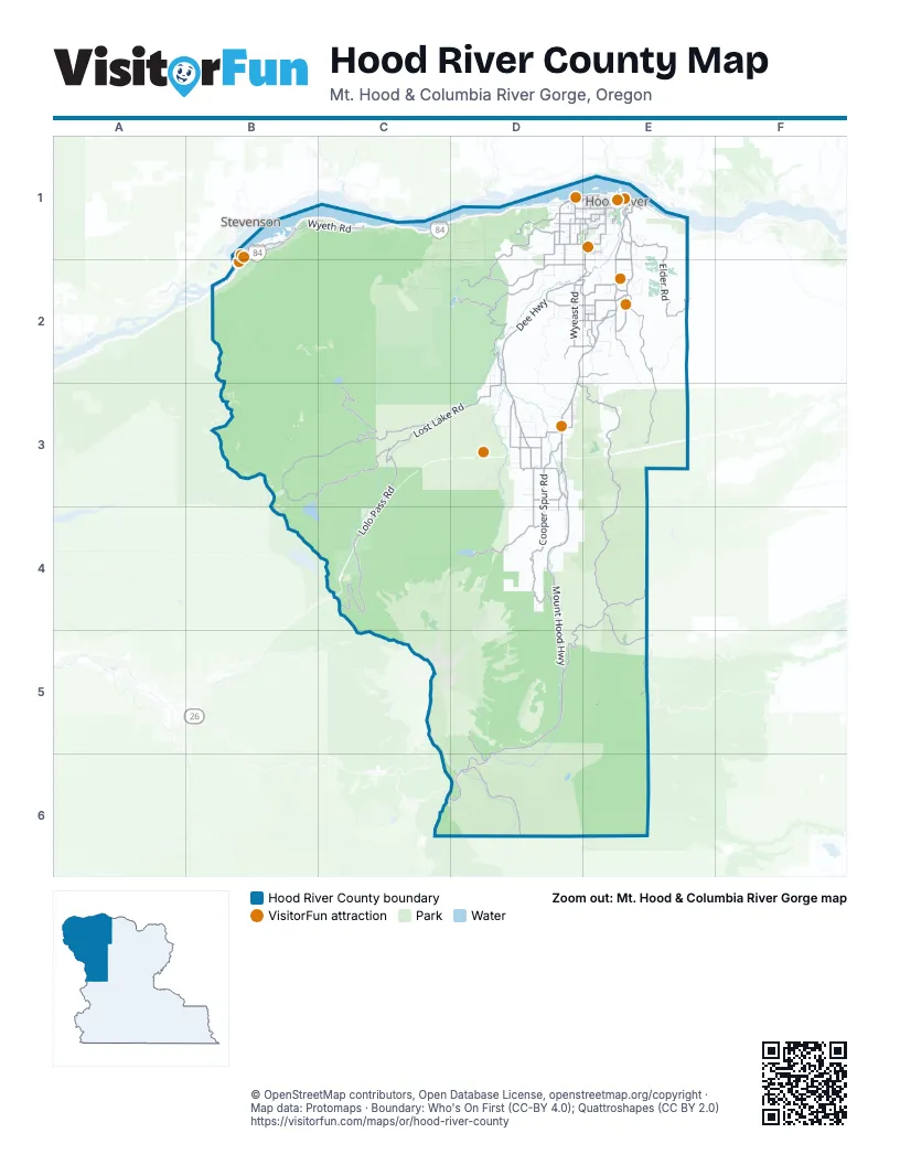
Street index of Hood River County
Each street on the sheet and the grid squares it crosses.
- Columbia River HighwayB1, C1, D1, E1, B2
- Mount Hood HighwayE1, D2, E2, D3, D4, D5, C6, D6
- Tucker RoadE1, D2, E2
- Odell HighwayD2, E2
- Frontage RoadB1
- May StreetD1, E1
- Cascade AvenueD1, E1
- Davis DriveD2, E2
- Wa-Na-Pa StreetB1, B2
- Old Columbia River DriveE1
- 12th StreetE1
- 13th StreetE1
- Oak StreetE1
- Hood River BridgeE1
- 2nd StreetE1, D3
- Bridge of the GodsB2
- Button Bridge RoadE1
- East State StreetE1
- North 2nd StreetE1
- Front StreetE1
- Dee HighwayD2, D3
- Brooks Meadow RoadD4, E4, D5
- Wamic RoadD6
- Country Club RoadD1, D2
- Dufur Valley RoadE4, E5
- Belmont DriveD1, E1
- Baseline DriveD3
- Hood River HighwayD3
- Baseline RoadD3
- Barrett DriveD1, E1
- Indian Creek RoadE1
- Belmont AvenueE1
- Wine Country AvenueD1, E1
- Mount Adams AvenueE1
- Lost Lake RoadD2, B3, C3, D3
- Lolo Pass RoadC3, C4
- Forest Road 13B3, C3
- Cooper Spur RoadD3, D4
- Forest Road 17E3, E4
- Fir Mountain RoadE2, E3
- Kingsley RoadD2
- Riordan Hill DriveD1, D2
- Elder RoadE1, E2
- Wahtum Lake RoadC3
- Binns Hill RoadD2
- Eastside RoadE1, E2
- Neal Creek RoadD2, E2
- Post Canyon DriveD1
- Wyeth RoadB1, C1
- Laurance Lake RoadD4
- Wyeast RoadD2, E2
- Clear Creek RoadD3, D4
- Trout Creek Ridge RoadD3
- Forest Road 1720E4
- Surveyor's Ridge RoadE3, E4
- Woodworth DriveD3
- Kingsley Guard Station RoadD2
- Pine Mont DriveD3, E3
- Dethman Ridge RoadE2
- Forest Road 4420E5
- Portland DriveD2, E2
- Thomsen RoadE2
- Old Dalles DriveE1
- Summit DriveD2, E2
- Northwest Forest LaneB1
- Old Parkdale RoadD3
- Central Vale RoadD2, E2
- Miller RoadD3
- Westcliff DriveD1, E1
- Mount Hood Meadows RoadD5, D6
- Ehrck Hill DriveE2
- Straight Hill RoadE2
- Allen RoadD3
- Eugene StreetE1
- Frankton RoadD1
- Punchbowl RoadD2
- Methodist RoadD1
- Alameda RoadD1
- Hutson DriveD3
- Bassler DriveD3
- Neal Creek Mill RoadE2
- Brookside DriveE1
- Markham RoadD1, D2
- Highline RoadE1
- Jordan RoadD3, D4
- Avalon DriveE1
- Toll Bridge RoadD3
- 4th StreetE1
- Paasch RoadE1
- Lingren RoadE2
- Massee Grade RoadE2
- State StreetE1
- Sunset RoadB1, D1
- Van Horn DriveE2
- A G A RoadE2
- Evans Creek DriveD4
- Whiskey Creek DriveE1
- Glass RoadE2
- Fairview DriveD1, E1
- Rand RoadE1
- Lost Lake Campground RoadB3, B4
- 6th StreetE1
- Chevron DriveE2
- Serpentine RoadE1
- Jaymar RoadE1
- North 20th StreetE1
- Neal Mill RoadE2
- Herman Creek ConnectorB1
- Forest Road 16C3, D3, C4
- Forest Road 1710E2, E3
- Green Point RoadC2, D2
- Cloud Cap RoadD4, D5
- Forest Road 1610D3, C4, D4
- Gilhouley RoadD2, D3
- Jones Creek RoadB3, C3, C4
- Tony Creek RoadD2, D3
- Booth Hill RoadE2, E3
- Forest Road 1650C4
- Forest Road 3560D6
- Hood River RoadD5, D6
- Larch Mountain RoadC2, D2
- Laurance Lake Road (NF-2840)C4, D4
- Forest Road 3540D5, D6
- Forest Road 1811C4
- Forest Road 4811E6
- Reed RoadD2
- Lookout Mountain RoadD4, E4, D5, E5
- Wells DriveE2
- Lookout Mountain Road 4410E5
- Huskey RoadE2
- Culbertson DriveD3
- Sherman AvenueE1
- Hidden Oaks DriveE1
- Forest Road 1711E3
- York Hill DriveD1, D2
- Montello AvenueE1
- Orchard RoadE1
- Willow Flat RoadE2
- Smullin DriveD3
- Chamberlain DriveD2
- Forest Road 1700-620E3
- Dog River RoadD4
- Lippman RoadD2
- Prospect AvenueE1
- Barlow RoadD6
- Kenwood DriveD2
- Green RoadD2, D3
- Forest Road 1700-640E3
- Collins RoadD3
- Wasco StreetE1
- Redgate RoadE3
- Imai RoadD3
- Quinn DriveD3
- Hays DriveD1, E1
- Billings RoadD3
- Mason RoadE2
- Webster RoadE2
- Canyon RoadD2
- Baldwin Creek DriveD3
- Husky RoadE2
- Alexander DriveD3
- Columbia StreetE1
- Northwest Portage RoadB1, B2
- Nottingham Campground LoopD5
- Copper Dam RoadE1, E2
- 8th StreetE1
- Kollas RoadD2
- Nunamaker RoadE1
- Gilkerson RoadE2
- Forest Road 1700-630E3
- Riverside DriveE1, D2
- Red Hill DriveD3
- 22nd StreetE1
- Cooper Spur Ski Area RoadD4
- Alexander RoadD3
- Jeastrup RoadE1
- London DriveD4
- Wheeler RoadD2
- Oleary RoadD2, D3
- Alder RoadD3
- Multnomah RoadD1
- Phelps Creek RoadD1
- Sperry RoadD3
- Tony Mohr DriveE2
- Sylvester DriveD2
- Red Hill RoadD3
- Hess RoadD3
- Lava Bed DriveD3
- Westwood DriveD1
- 9th StreetE1
- Mitchell Point DriveD1
- Scott RoadE2
- Frazer DriveD1
- Riverdale RoadD2
- 3rd StreetE1
- Broken T DriveE1
- Tyler DriveD1
- 5th StreetE1
- Blossom Hill DriveE1
- Fir Mountain LoopE2
- Leisure DriveD3
- June StreetE1
- Semmes DriveD3
- Sunday DriveE2
- Swyers DriveE2
- Hazel AvenueE1
- Cunningham DriveD3
- 7th StreetE1
- Kingdon RoadE2
- Oak Ridge DriveE1
- Hillcrest DriveD2, D3
- Crag Rat RoadE2
- Eliot DriveE1
- 10th StreetE1
- North Hillcrest RoadD2
- Crusher DriveD3
- Pacific AvenueE1
- McIntosh DriveD4
- Gravel Pit RoadB1
- Stadelman DriveE2
- Blackburn DriveD2, E2
- Windsong DriveB1
- Shute RoadD2
- Berry DriveD3
- Fletcher DriveD2, E2
- Auberts DriveD3
- Boneboro RoadD3
- Pine StreetE1
- 30th StreetE1
- Portway AvenueE1
- Meadowbrook RoadE2
- Stricker RoadE1
- Experiment Station DriveE1
- Pheasant DriveD2, E2
- Dry Creek RoadB1, B2
- Bone DriveE2
- Lacey DriveE1
- Green Mountain DriveD3
- Southwest Ruckel StreetB1
- B StreetE1
- Sherrard RoadE2
- Lincoln StreetE1
- Sieverkropp DriveE1
- Industrial StreetE1
- Redwood RoadE2
- Oregon RoadD3
- Mohr DriveE2
- McCrum DriveD3
- Acree DriveD2, E2
- 18th StreetE1
- Eagle LoopD2, E2
- Mountain View DriveB1, E1
- 17th StreetE1
- North 1st StreetE1
- Henderson RoadE1
- Summitview DriveD1
- Tilly Jane House RoadD5
- Carson Hill DriveD3
- Klm DriveD3
- Mud Alley RoadE2
- Herman Creek Campground RoadB1
- Morton RoadD1
- 20th StreetE1
- Eby RoadE1
- West ForkD2
- C StreetE1
- Riverview DriveE1
- Martin RoadE1
- 16th StreetE1
- East Port Marina DriveE1
- Madison RoadD3
- Firwood DriveD1
- Airport DriveE1
- Taylor AvenueE1
- Jeanette RoadE1
- A StreetE1
- Air Museum RoadE1
- Furrow DriveE2
- White Fir DriveD2, D3
- Benton RoadE2
- Bonneville DriveE1
- Graves RoadE2
- Pearaday Orchard RoadD3
- Mc Isaac DriveD3
- Parkdale Cemetery RoadD3
- Arrowhead AvenueE1
- Bartlett DriveD2
- Pioneer RoadE1, E2
- Southwest Portage RoadB1
- Barker RoadE1
- Lichens RoadE1
- Lower Mill DriveE2
- Herman Creek LaneB1
- 4th AvenueD3
- Clearwater LaneE1
- Old Columbia River HighwayB2
- Webb DriveD2, E2
- Bailey RoadD3
- Rawson RoadD1, E1
- Wooded Acres DriveD1
Things to do on the Hood River County map
- Mount Hood Railroad
- Always Catchin Fishing Charters
- Bike the Gorge
- Cascade Locks
- Cascade Locks Historical Museum
- Draper Girls Country Farm
- Ebike Multnomah Falls
- Gorge Sail Ventures
- Hood River
- Hood River Fruit Loop
- Packer Orchards
- The Fruit Company Museum & Factory Store
- Western Antique Aeroplane and Automobile Museum
Places on the map
- Badger Lake
- Barrett Park
- Benson Plateau
- Bonney Meadows
- Bottle Prairie
- Brooks Meadow
- Cascade Locks
- Cascade Locks Marine Park
- Cascade Locks State Airport
- Coalman Glacier
- Coe Glacier
- easyCLIMB Trail
- Eliot Glacier
- Elk Cove
- High Prairie
- Hood River
- Indian Creek Golf Course
- Kingsley Reservoir
- Ladd Glacier
- Lang Forest State Scenic Corridor
- Laurance Lake
- Lindsey Pond
- Lost Lake
- Mark O. Hatfield Wilderness
- Mesa Terrace
- Mount Hood Wilderness
- Mt. Hood Meadows Ski Resort
- Newton Clark Glacier
- Odell
- Parkdale
- Parkdale Lava Flow
- Punchbowl Falls Park
- Richard L. Kohnstamm Memorial Area
- Starvation Creek State Park
- Toll Bridge County Park
- Viento State Park
- Wahtum Lake
- White River Glacier
- Wyeth State Recreation Area
- Wygant State Natural Area
Next to Hood River County
- Stevenson
© OpenStreetMap contributors, Open Database License, openstreetmap.org/copyright · Map data: Protomaps · Boundary: Who's On First (CC-BY 4.0); Quattroshapes (CC BY 2.0)















