

Rhode Island map
Providence-Warwick Metro Area map
The sheet's index lists 26 highways; I-95, I-195 and US 1 cross the most grid squares. Things to do inside the boundary: Bally's Lincoln Casino Resort, Bally's Tiverton Casino and Hotel and Battleship Cove. Also on it: Acushnet, Attleboro and Barrington.
Open the map (PDF, US Letter)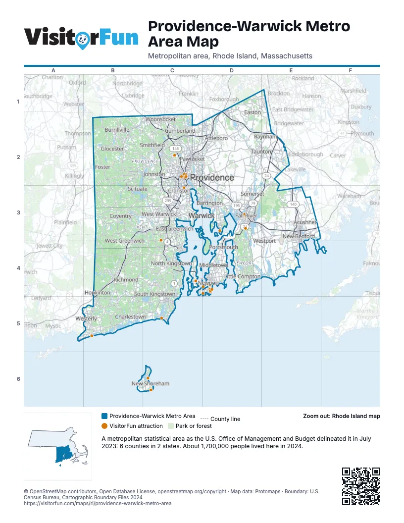
Highway index of Providence-Warwick Metro Area
Each highway on the sheet and the grid squares it crosses.
- I-95B3, B4, B5, C2, C3, D1, D2
- I-195C2, D2, D3, E3
- I-295C2, C3, D2
- I-495D1, D2, E2
- US 1B5, C2, C4, C5
- US 1AC2
- US 6B2, C2, D3, E3
- US 44C2, D2, E2
- RI 4C3, C4
- RI 10C2, C3
- MA 18E3
- MA 24D3, E2, E3
- RI 24D3, D4
- RI 37C3
- RI 78B5
- MA 79D3, E3
- RI 99C1, C2
- MA 106D1
- RI 114C3, D4
- MA 123D1, D2, E1
- MA 138D2, D3, E1
- RI 138C4, D3, D4
- MA 140D1, D2, E2, E3
- RI 146C1, C2
- MA 240E3
- RI 403C3, C4
Things to do on the Providence-Warwick Metro Area map
- Bally's Lincoln Casino Resort
- Bally's Tiverton Casino and Hotel
- Beavertail State Park
- Bellevue Avenue Historic District
- Benefit Street
- Blithewold Mansion, Gardens & Arboretum
- Block Island Ferry
- Brenton Point State Park
- Burlingame State Park
- Cape Verdean Museum
- Charlestown Breachway State Beach
- Cliff Walk
- Coastal Queen Cruises
- Coggeshall Farm Museum
- Federal Hill
- Fort Adams State Park
- Fort Wetherill State Park
- Gansett Cruises
- Gen. James Mitchell Varnum House
- Goddard Memorial State Park
- Green Animals Topiary Garden
- Haines Memorial State Park
- Herreshoff Marine Museum
- International Tennis Hall of Fame
- Jamestown Newport Ferry
- Kingscote
- Lincoln Woods State Park
- Marble House
- Misquamicut State Beach
- Mohegan Bluffs
- Museum of Newport History
- National Museum of American Illustration
- New England Wireless & Steam Museum
- Newport Classic Cruises
- Newport Tower
- Ocean Drive
- Providence Performing Arts Center
- Providence Place
- Rhode Island State House
- RISD Museum
- Rocky Point State Park
- Roger Williams National Memorial
- Roger Williams Park Zoo
- Rosecliff
- Sightsailing of Newport
- Slater Mill Historic Site
- Slavery Memorial (Brown University)
- The Breakers
- The Elms
- The Museum at the John Brown House
- Touro Synagogue
- Waterplace Park
- World War II Veterans Memorial State Park
Places on the map
- Acushnet
- Attleboro
- Barrington
- Burrillville
- Charlestown
- Coventry
- Cranston
- Cumberland
- East Greenwich
- Easton
- Fall River
- Foster
- Glocester
- Hopkinton
- Johnston
- Little Compton
- Middletown
- New Bedford
- New Shoreham
- Newport
- North Kingstown
- Pawtucket
- Portsmouth
- Providence
- Raynham
- Richmond
- Scituate
- Smithfield
- Somerset
- South Kingstown
- Taunton
- Warwick
- West Greenwich
- West Warwick
- Westerly
- Westport
- Woonsocket
© OpenStreetMap contributors, Open Database License, openstreetmap.org/copyright · Map data: Protomaps · Boundary: U.S. Census Bureau, Cartographic Boundary Files 2024