

Utah map
Sandy map
About 92,840 people live here (Census Bureau, 2024 estimate). The sheet's index lists 300 streets; Sego Lily Drive, Veterans Memorial Highway and 1300 East cross the most grid squares. Things to do inside the boundary: The Shops at South Town.
Open the map (PDF, US Letter)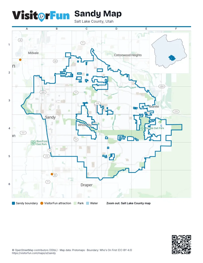
Street index of Sandy
Each street on the sheet and the grid squares it crosses.
- Veterans Memorial HighwayA2, B2, B3, B4, B5
- 1300 EastC2, C3, C4, C5, C6
- State StreetB2, B3, B4, B5
- 700 EastC1, C2, C3, C4, C5
- 9400 SouthA3, B3, C3, D3
- 9000 SouthA3, B3, C3
- 10600 SouthB4, C4, D4
- 11400 SouthB5, C5, D5
- Highland DriveD2, D3, D5
- Union Park AvenueC1, C2
- 750 EastC1
- Wasatch BoulevardE4, D5, E5
- Sego Lily DriveB3, C3, B4, C4, D4, E4
- 1700 EastD2, D3, D4, D5
- Dimple Dell RoadD4, E4
- Sandy ParkwayA2, A3
- 8600 SouthB2, C2, D2
- 7800 SouthB2, C2
- Centennial ParkwayB4
- 10000 SouthB4, D4, E4
- Little Cottonwood RoadD3, E3
- 1670 EastD5, D6
- Draper ParkwayD6
- Bingham Junction BoulevardA2
- Jordan GatewayA3
- Monroe StreetB3, B4
- 1000 EastC2, C4, C5
- 11000 SouthB5, C5
- 9800 SouthA3, B3, D3, E3, E4
- Pepperwood DriveD4, D5, E5
- Newcastle DriveD2, D3, E3
- 300 EastB2, B3, B4
- Mall Ring RoadB4
- Eastdell DriveD3, D4
- 300 WestB3, B4
- Riverside DriveA3
- Hidden Valley DriveC5, C6, D6
- 8680 SouthB2, C2
- Auto Mall DriveB4, B5
- Hidden Valley RoadC5, D5, C6
- Creek RoadC1, C2, D2
- 8800 SouthB3, C3
- Alta Canyon DriveD2, E2, E3
- 700 WestA2, A3
- High Point ParkwayC2
- 10200 SouthB4
- Mt Jordan RoadE3, E4
- Harrison StreetB2, B3
- Main StreetA2, B2
- Petunia WayC3, D3, C4
- Sterling DriveD3
- Towne Ridge ParkwayB3
- Michael WayD3
- Vista WayB5
- 2000 EastD4, D5
- 8000 SouthB2, C2
- 9120 SouthA3, B3, C3
- Greenwood AvenueB1
- 280 EastB2, B3
- Creek Run WayB4
- 2125 EastD5
- 11340 SouthD5
- Mount Jordan RoadE3
- 11270 SouthD5
- Forbush LaneC2
- 685 EastC2
- 120 WestB4
- 11370 SouthD5
- 2300 EastD3
- Falcon WayD3, E3
- Lone HollowD5, E5
- Nicklaus RoadD5, C6, D6
- Quail Hollow DriveD3, E3
- Beetdigger BoulevardB4
- Willow Hills DriveD3, E3
- Pioneer AvenueB2, C2
- 150 EastB2, B3, B5
- Viscounti DriveD2
- 220 EastB2, B3
- Wanderwood WayE4, D5, E5
- Quail Run DriveD3, E3
- High Mountain DriveD5, E5
- Bells Canyon Reservoir Service RoadE4, F4
- Glacier View DriveD4, E4
- Sandy Creek DriveC5
- Countrywood DriveD4
- Hidden Valley Club DriveD5, D6
- 865 EastC2, C4
- Dry Creek RoadC5
- Harvard Park DriveC2, C3
- Buttercup DriveC4, D4
- 360 EastB2, B3, B4
- Woodchuck WayD3, E3
- Quarry Bend DriveC3
- Sunburn LaneC5
- 8640 SouthB2, D2
- 170 EastB3
- Northridge WayE4, E5
- Lafayette StreetC4
- 9270 SouthB3, C3
- Flint DriveC3, C4
- Snow Mountain DriveD2, E2
- Roseboro RoadD3, D4
- Edgecliff DriveC4, D4
- Terrace DriveD2
- Plata WayC3, D3
- Grambling WayC2
- Savannah DriveC4, C5
- Lostwood DriveE4, E5
- Mumford DriveC3, C4
- Willow Brook WayD5
- Hagan RoadC5, D5
- Sanders RoadC5
- Oak Manor DriveD5
- Eagle View DriveE5
- 400 EastB2, B3, B4
- High Mesa DriveD5
- Weeping Willow DriveB4
- Karalee WayD4, E4
- 1210 EastC3, C4
- Cedar Ridge RoadC5, C6
- Ida LaneD2, D3
- Waters LaneC3, D3
- Golden Willow DriveB4
- David StreetB3
- 10980 SouthD5
- Locust StreetB3, C3
- Heytesbury LaneD4
- Hawkwood DriveC5
- 60 EastB2, B3
- Cottage AvenueB2
- Greenwood DriveB3
- 250 EastB2, B3
- Pineridge RoadC5, C6
- Bluff View DriveC5, C6
- Hiddenwood DriveE4, E5
- Granada DriveC3, D3
- Raintree DriveD3
- Green WayC2, C3
- 8760 SouthB2
- Sandy Dunes DriveC5
- Calla Lily WayC4, D4
- 8400 SouthB2, C2
- Peach Blossom DriveC3
- Grand View DriveE3
- 520 EastB1, B2, B3
- Windy Peak Ridge DriveC5
- Barrett Park DriveD5
- Ascot ParkwayC4, C5, D5
- 10300 SouthB4, D4
- Woodridge RoadC5, C6
- Calnette DriveB4, C4
- Prescott DriveD4, D5
- 40 EastB2, B3
- Center StreetB2, B3
- Wyandotte AvenueB3, C3
- 540 EastB3, B4, C4
- Aspen Ridge RoadC5, C6
- 2165 EastD4
- Oak Grove DriveE5
- Bay Meadow DriveC4, C5
- Flat Iron DriveD3
- Seven Springs DriveE4
- 120 EastB2, B3
- Gyrfalcon DriveD4
- Durban RoadE3
- 465 EastB4, B5
- 90 EastB2, B3
- Leilani DriveC4
- Rimando WayB3
- Silver Sage DriveC4
- 8220 SouthB2, C2
- Wayside DriveC2
- Sublette PlaceD2
- Stanley DriveC3, D3
- Cedar Terrace DriveC2
- Rollingwood LaneD5
- Tortellini DriveD3
- 535 EastB2, C2, B4
- Cy's RoadC3
- Ksel DriveE3
- 10095 SouthD4
- 1380 EastC3, C5
- Ohenry RoadB5
- Casper RoadD5
- 1330 EastC2, C5
- 3100 EastE3, E4, E5
- Autumn Ridge DriveD5, D6
- Longdale DriveC5, D5
- Clearview DriveB4
- Fox Hunt DriveD3, E3
- Spring Ridge DriveC6
- Sandy Ridge DriveC5
- Tramway DriveD3
- 8125 SouthC2
- Old Dairy RoadC2
- Paulista WayD2
- Whirlaway LaneD4, D5
- Cassowary DriveE5
- 10375 SouthB4, C4
- Tameron DriveC4, D4
- 10120 SouthB4, C4
- Willow Bend DriveE3
- Bryce DriveB2
- 8685 SouthC2, D2
- Eastridge RoadC5
- Copper Creek RoadC3, D3
- Johnsonway DriveC2
- Gracey LaneD5
- Lazon DriveC3
- Hidden View DriveB5
- Buttonwood DriveD3
- Mulberry WayC2, D2
- 115 EastB2, B5
- Albion Village WayB3
- Cameo WayD3
- Cheshire DriveD3, E3
- Debeers DriveD3
- Scirlein DriveC3
- 420 EastB2, B3, B4
- Crescent Oak WayB5
- 8920 SouthB3
- Hidden Brook BoulevardE5, E6
- Edenbrook DriveC4, C5
- Flanders RoadD4
- Webster DriveC3
- Willow View WayD5
- Ridgemark DriveC3, D3
- Budding DriveC4, D4
- Richard RoadD3
- Sunridge DriveD2, D3
- Blossom DriveC4
- Ashley Mesa LaneD4
- 8960 SouthB3
- Maio DriveD2
- Village Shop DriveC3
- Howard DriveB3, C3
- Pinehurst DriveD3, D4
- Piper LaneD2, D3
- Ashley Ridge RoadD4
- WindsongE5
- Maison DriveD3
- Sunwood LaneD5
- Hidden Valley BoulevardD5
- Floyd DriveB3, C3
- 8180 SouthB2, C2, D2
- Cobblestone WayE3
- Spartan DriveC2, C3
- Civic Center DriveB4
- 8840 SouthB3
- Rocklin DriveD3
- 8880 SouthB3
- Rose Cottage WayC3
- Canyon Gate RoadE3
- Winter Wren DriveE3
- 440 EastB2, B3, B4
- Jordan View DriveB5
- Crescent View DriveD5
- Player RoadD5
- Rio WayD2
- Tall Pines WayD5
- Monroe Plaza WayB3
- Susan DriveD5
- Hidden Canyon LaneE5, E6
- Wood Glen CircleD4
- Kalinda DriveD4
- 8280 SouthC2
- 9670 SouthB3, C3
- Willow Wick DriveE3
- Cobblemoor LaneE3
- Kimsbrough RoadD4
- Madrid WayC2, D2
- Secret View RoadE5
- Williamsburg Park CircleC2
- Garland WayD3
- Trevino RoadC5, D5
- Carriage Chase LaneD3
- Cliff Swallow DriveD3, E3
- Village Point WayD3
- Altair DriveD2, D3
- Snow Forest LaneE5
- Glider LaneD2
- Kramer DriveD3, D4
- Crosshill LaneE5
- Chylene DriveE3, E4
- Wyngate LaneD5
- Sandia Hills DriveC3
- 450 EastB2, B3
- Sandy Oaks DriveB2
- Scenic Valley LaneE5
- Midvillage BoulevardB4
- Meadow Lark WayD3
- Sandy Gulch RoadC5
- Silvercrest DriveC3, D3
- Tonya DriveB3, B4
- Bentwood LaneE5
- Snowstar LaneD4, D5
- Jordan Oaks DriveA3
- Brisbane DriveC5
- 2020 EastD3, D4
Things to do on the Sandy map
Places on the map
- Albion Middle School
- Alta Canyon Park
- Alta Canyon Post Office
- Alta High School
- Alta View Hospital
- Altara Elementary School
- America First Field
- Amphitheater Park
- Bicentennial Park
- Brandon Park
- Brookwood Elementary School
- Costco
- Crescent Elementary School
- Crescent View Middle School
- Dewey Bluth Park
- Diamond Ridge High School
- Dimple Dell Park
- Dimple Dell Regional Park
- East Sandy School
- Eastmont Middle School
- Falcon Park
- Flat Iron Mesa Park
- Flatiron Mesa
- Grandpa's Pond
- Granite Elementary School
- Granite Park
- Hidden Valley Country Club
- Hidden Valley Park
- Indian Hills Middle School
- Jordan Commons
- Jordan High School
- Lake Hills Memorial Estates
- Larkin Sunset Gardens
- Lone Peak Elementary School
- Lone Peak Park
- Quail Hollow Park
- Quarry Bend
- River Oaks Golf Course
- Shops at South Town
- The Commons at Southtowne
Next to Sandy
- Cottonwood Heights map
- Draper map
- Granite
- Midvale map
- White City
© OpenStreetMap contributors, Open Database License, openstreetmap.org/copyright · Map data: Protomaps · Boundary: Who's On First (CC-BY 4.0); Quattroshapes (CC BY 2.0)















