

Utah map
Wasatch County map
About 37,858 people live here (Census Bureau, 2024 estimate). The sheet's index lists 300 streets; West Side Strawberry Road, Soldier Creek Recreation Complex Road and 200 South cross the most grid squares. Things to do inside the boundary: Heber Valley, Heber Valley Railroad and Uinta Recreation.
Open the map (PDF, US Letter)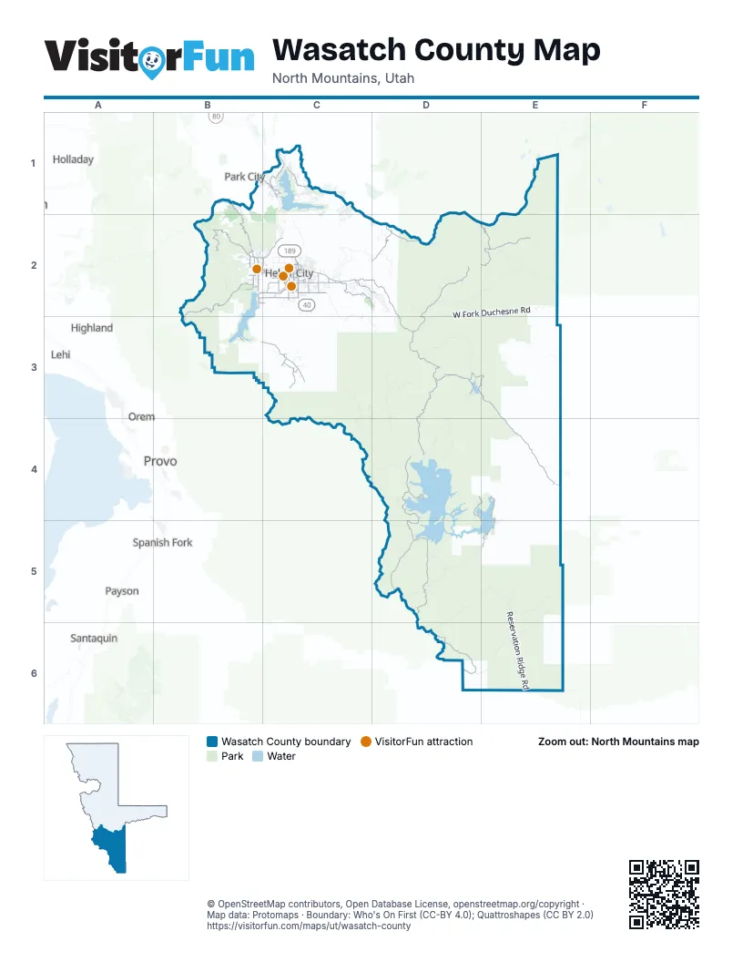
Maps inside Wasatch County
1 map inside, from the street map of Wasatch County down.
Street index of Wasatch County
Each street on the sheet and the grid squares it crosses.
- River RoadC2
- South Center StreetB2, C3
- West Midway LaneC2
- South Charleston RoadB2
- Main StreetB2, C2
- South Main StreetC2
- State StreetD6
- 1200 SouthC2
- 400 EastC2
- West 100 SouthC2
- North Main StreetC2
- Highway 40E4
- Provo Canyon RoadB3
- West Side Strawberry RoadD4, D5, D6
- Lake Creek RoadC2, D2
- Pine Canyon RoadB1, B2
- Unicorn Ridge - Indian Creek RoadD5
- North Jordanelle ParkwayC1
- Heber Valley Camp ParkwayC2, D2
- East 1200 SouthC2
- West 3000 SouthB2, C2
- East Lake Creek RoadC2
- South Mill RoadC2
- West Main Canyon RoadB3, C3
- East Center StreetC2
- 900 NorthC2
- 200 WestB2, C2
- West 200 NorthB2, C2
- Homestead DriveB2
- East 3000 South StreetC2
- Burgi LaneB2, C2
- State Route 319C1
- Mirror Lake HighwayE1
- Jordanelle ParkwayC1
- Browns Canyon RoadC1
- 1050 EastC2
- Cari LaneB2
- West Main StreetC3
- North Mill RoadC2
- North 1200 EastC2
- Mill RoadC2
- Co-op Creek RoadD3, D4
- Cascade Springs DriveB2, B3
- Lake Creek - Currant Creek RoadD2, D3
- Mill Hollow - Duchesne River RoadD2, D3
- Soapstone RoadE2
- Snake Creek Canyon RoadB2
- Currant Creek RoadE3, E4
- West Side Currant Creek RoadD3, E3
- Aspen Grove RoadE4, E5
- Bench Creek RoadD2
- North Wolf Creek Ranch RoadD2
- Soldier Creek Recreation Complex RoadD4, E4, E5
- Longview DriveC1
- East Main Canyon RoadC3
- Deer Hollow RoadB1, C1
- East 2400 South StreetC2
- Lake Pines DriveC2, D2
- Little Valley RoadC3
- Guardsman Pass RoadB1
- Strawberry Bay Complex RoadD4
- Strawberry Ranch RoadE5
- Soapstone Basin RoadE2
- Stringtown RoadB2
- South 2400 East StreetC2
- South 3600 EastC2
- Michie LaneB2, C2
- West 2400 SouthB2, C2
- Airport RoadC2
- Little Hobble Creek RoadC3
- Coyote Canyon ParkwayC2
- West 650 South StreetC2
- Southfield RoadC2
- South 300 WestC2
- Valley Hills BoulevardC2
- Casperville RoadC2
- Church Camp RoadC2
- East 200 SouthC2, C3
- State Route 314B3
- East 600 SouthC2
- South Daniel RoadC2
- North Center StreetB2, C3
- Sawmill BoulevardC2
- 500 SouthB2, C2
- South 500 EastC2
- West 1200 SouthC2
- South Round Valley LaneC3
- North Shoreline DriveC1
- South Daniels RoadC2
- Foothill BoulevardC2
- Providence DriveC2
- Industrial ParkwayC2
- South 600 WestC2
- Cobblestone DriveC2
- 100 SouthB2, C2
- West 500 NorthC2
- Cummings Memorial DriveC2
- East 500 NorthC2
- 500 EastC2
- South 1140 West StreetC2
- Warm Springs RoadB2
- West 3600 SouthB2, C2
- North 750 EastC2
- West 600 SouthC2
- Tate LaneB2
- West 1000 SouthC2
- 250 WestB2
- 200 EastB2, C3
- South 4800 EastC2
- 980 SouthC2
- North 500 EastC2
- 319 Connector RoadC1
- 200 SouthB2, C2, C3
- Valley Hills DriveC2
- 100 WestB2
- East Valley Hills BoulevardC2
- 1000 WestC2
- 1300 SouthC2
- West Cobblestone DriveC2
- Richardson Flat RoadC1
- 5700 EastC2
- Pine Canyon DriveB2
- 50 WestB2
- Heber ParkwayC2
- Alpine Scenic HighwayB3
- 750 West StreetB2
- 1500 SouthC2
- South Bench Creek RoadD2
- West Fork Duchesne RoadD2, E2, D3
- Reservation Ridge RoadE5, E6
- Willow Creek Ridge RoadD5, E5, D6
- Devils Notch RoadD5, E5
- Center Creek RoadC2, C3, D3
- Cummings Parkway RoadB2
- Duchesne Ridge RoadD2, E2
- Right Fork White River RoadD6, E6
- Timber Canyon RoadE5
- Trout Creek RoadD4
- Currant Ridge RoadD3
- Strawberry River RoadD3, D4, E5
- Low Pass Creek RoadD3
- Circle - Main Canyon RoadC3, D3, D4
- Silver Meadows RoadE2
- Long Ridge RoadE5, E6
- Bjorkman Hollow RoadD3
- North Trappers Loop RoadD2
- Westward Ho RoadC2
- Cold Springs RoadE2
- Coyote Canyon RoadC2
- Big Springs RoadD5
- Chicken Creek RoadD4
- East Forest Creek RoadC2, D2
- Clyde Creek RoadD4
- Big Pole RoadC2
- Kweeyahgut - Horse Connect RoadD4, D5
- Heber Mountain RodD2
- Campbell Hollow RoadD2
- Uinta DriveC1
- Buffalo Canyon RoadD5
- Murdock Bench RoadC3, C4
- Mill Hollow Ridge RoadD2
- Old Highway 40C1, C2
- Bald Mountain RoadD5
- Aspen DriveB2, E4, E5
- Pine Valley RoadD2
- Ridgeline DriveC2
- Kweeyahgut Creek RoadD5
- Tuhaye Park DriveC1
- Interlaken DriveB2
- Blue Spruce DriveD2
- Moon Light DriveC1, C2
- Layout Canyon RoadE3
- Murdock Basin RoadE1
- Ridgeway DriveC1
- Indian Springs RoadD5
- Deer Dreek Campground RdB2
- West 1200 North StreetC2
- Whispering WayC2
- West View DriveC2
- American Fork - Snake Creek RoadB2
- Caddis DriveC1, C2
- Canyon DriveB2
- Spring Access RoadD3
- Timber Lakes DriveC2, D2
- Chicken Creek West Day Use RoadD4
- North 525 West StreetC2
- Woodland Crest RoadD2
- Summit View DriveB1
- Mill Hollow RoadE3
- Deer Crest Estates DriveB1, C1
- Rhodes Canyon RoadE2
- Chimney Rock RoadC2
- Wild Mare WayC2
- Victory Ranch DriveC1
- North 1750 West StreetC2
- Haws Point Day Use RoadD4
- East Greenerhills DriveC2
- Evening Star DriveC1, C2
- Deer Canyon DriveC1
- Blue Ledge DriveC1
- Deer Creek DriveC2, D2
- Soldier Creek Below Dam RoadE5
- Strawberry DriveE4
- Ridge Pine DriveC2, D2
- LIttle Pole Canyon RoadC2
- Sundowner Ridge DriveC1
- Hidden WayB1, B2
- Haystack Mountain DriveC2
- South Pole DriveC2
- Twelve Hundred Dollar RoadE5
- Bryants Fork RoadD4
- Oak Hill LaneC3
- Switzer DriveB2
- River View DriveC2, D2
- Reservoir View DriveC1
- Peace Tree TrailC1
- Deer Mountain BoulevardC1
- La Sal Peak DriveC2
- Ibapah Peak DriveC2
- SkyRidge DriveC1
- Red Ledges BoulevardC2
- Clubhouse RoadC2, D2
- Strawberry River Gravel Pit RoadD4
- East Little Sweden RoadC2
- Crooked Creek 2 RoadD5
- West 1800 North StreetC2
- Campbell Hollow Ridge RoadD2
- North 1130 West StreetC2
- Blazing Star WayD2
- Bryants Fork Summer Home RoadD4
- Strawberry Lakeview DriveD4, E4
- 100 NorthB2, C2, C3
- Explorer Peak DriveC2
- Dutch Canyon RoadC2
- South 100 WestC2, C3
- 400 SouthB2, C2
- 820 EastC2
- North 100 WestB2, C2, C3
- Willow Creek Lower RoadD3, D4
- West Potters LaneC2
- Meadow DriveB3
- South 1200 WestC2
- Old Kamas HighwayC1
- 2400 NorthC2
- Aspen RoadD2
- West 100 NorthB2, C2, C3
- Layout RoadD3, D4
- Lime Canyon RoadB2
- 1490 EastC2
- Green Briar RoadD2
- North 600 WestC2
- Diamond Bar X RoadD2
- Waters Edge RoadC2
- East Fork Mill Hollow RoadD2
- Big Hollow RoadC2
- Tuhaye HollowC1
- Beaver Bench RoadC2
- Mayflower Village DriveC1
- Woodland WayD2
- Tanglewood DriveD2
- Granite Rock LoopC1
- Cottonwood LoopB2
- Swiss Alpine RoadB2
- Fireside DriveC1, C2
- Little Pole RoadC2
- Mud LaneC3
- 4800 EastC2
- Buck WayD2
- North Warm Valley DriveC3
- Chipman RoadD5
- Wards LaneB2
- Fox Den RoadB2, C2
- Cougar Moon WayC1
- Smith Esther LoopC2
- Deyhour RoadB2
- Laural Wood StreetC2
- Sunset View DriveC1
- Badger Hollow DriveD4
- Cougar Moon DriveC1
- Duke LaneC2
- 100 EastB2, C3
- East 600 NorthB2, C2
- Red Knob WayC2
- Alpine AvenueC1
- Little West Fork Loop RoadD3
- Currant Creek Campground RoadD3
- Copper Belt DriveC2
- North Dutch Highland DriveC2
- North 200 WestC2, C3
- Paved PathB2
- Slalom Run DriveC1
- Boulder Top WayC2
- Cottonwood LaneD2
- Ski Beach WayC1
- Galena Ridge WayC1
- Wakara DriveC1
- Upper RoadE4
- South Duke LaneC2
- North Callaway DriveC2
- South 100 EastB2, C2, C3
Things to do on the Wasatch County map
Places on the map
- Aspen Grove Campground
- Aspencrest Camp
- Boundary ATV Loop Trail
- Camp Aspen Lakes
- Camp Cloud Rim
- Charleston
- Chokecherry Campground
- Cobblestone Park
- Currant Creek Campground
- Currant Creek Reservoir
- Daniel
- Deer Creek Reservoir
- Deer Creek State Park
- Deer Valley Resort
- Encompass Health
- Euclid Timber Frames
- Haws Point Picnic Area
- Heard It Both Ways Trail
- Heber
- Heber Valley Camp
- Hideout
- Homestead Golf Club
- Independence
- Interlaken
- Jordanelle Reservoir
- Jordanelle State Park
- Lodge Pole Campground
- Midway
- Red Ledges
- Soldier Hollow
- Soldier Hollow Golf Course
- Strawberry Bay Campground
- Strawberry Reservoir
- Timber Lakes
- Victory Ranch Golf Club
- Wallsburg
- Wasatch Mountain State Golf Course
- Wasatch Mountain State Park
- Wile E. Canyon Loop Trail
Next to Wasatch County
© OpenStreetMap contributors, Open Database License, openstreetmap.org/copyright · Map data: Protomaps · Boundary: Who's On First (CC-BY 4.0); Quattroshapes (CC BY 2.0)















