

Virginia map
Richmond map
About 233,655 people live here (Census Bureau, 2024 estimate). The sheet's index lists 287 streets; Richmond-Petersburg Turnpike, Cherokee Road and Riverside Drive cross the most grid squares. Things to do inside the boundary: American Civil War Museum, Virginia Museum of Fine Arts and Virginia Tourism Corporation.
Open the map (PDF, US Letter)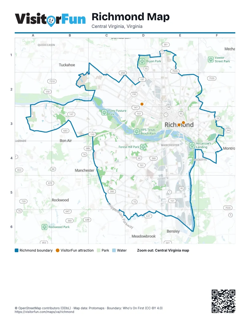
Street index of Richmond
Each street on the sheet and the grid squares it crosses.
- Patterson AvenueC1, C2, D2
- Three Chopt RoadC1, C2
- Azalea AvenueD1, E1
- Bellevue AvenueD1, E1
- Beltline ExpresswayD1, D2, D3
- Brook RoadD1, E1, E2, E3
- Dumbarton RoadD1
- East Saunders AvenueD1, D2
- Fauquier AvenueD1, E1
- Hermitage RoadD1, D2
- Richmond-Petersburg TurnpikeD1, D2, E2, E3, E4, E5, E6
- Saunders AvenueD1, D2
- West Laburnum AvenueD1, E1, D2
- Westbrook AvenueD1, E1
- Chamberlayne AvenueE1, E2, E3
- Chamberlayne RoadE1
- North AvenueE1, E2
- Old Brook RoadE1
- Cherokee RoadA2, B2, A3, B3, C3
- Croatan RoadA2, A3
- Chippenham ParkwayB2, B3, C3, C5
- Edward E Willey Memorial BridgeB2
- Huguenot RoadB2
- North Huguenot RoadB2, B3
- River RoadB2, C2
- Riverside DriveB2, C2, C3, D3, D4
- Cary Street RoadC2, D2
- Grove AvenueC2, D2, D3
- Libbie AvenueC2
- Malvern AvenueC2, D2
- Monument AvenueC2, D2, D3
- Staples Mill RoadC2
- West Broad StreetC2, D2, D3, E3
- Westmoreland StreetC2, D2
- Willow Lawn DriveC2
- Brookland ParkwayD2, E2
- Cameron StreetD2
- Dabney RoadD2
- Ellwood AvenueD2, D3
- Floyd AvenueD2, D3, E3
- Kensington AvenueD2
- Maywill StreetD2
- North Allen AvenueD2, D3
- North Arthur Ashe BoulevardD2, D3
- North Hamilton StreetD2
- North Meadow StreetD2, D3
- North Robinson StreetD2, D3
- North Thompson StreetD2
- Overbrook RoadD2, E2
- Powhite ParkwayD2, C3, D3
- Robin Hood RoadD2, E2
- Roseneath RoadD2
- Sherwood AvenueD2, E2
- South Hamilton StreetD2
- South Thompson StreetD2
- West Cary StreetD2, D3, E3
- West Clay StreetD2, E3
- West Leigh StreetD2, E2, E3
- West Marshall StreetD2, E3
- Westwood AvenueD2, E2
- 4th AvenueE2
- Admiral StreetE2
- Bowe StreetE2, D3
- Carolina AvenueE2
- Dill AvenueE2, F2
- Dove StreetE2
- East Brookland Park BoulevardE2
- East Ladies Mile RoadE2
- Hazelhurst AvenueE2
- Hunt AvenueE2
- Magnolia StreetE2, F2
- Meadowbridge RoadE2
- Mitchell StreetE2
- Monteiro StreetE2
- North 1st StreetE2, E3
- North 2nd StreetE2, E3
- North 5th StreetE2, E3
- North Harrison StreetE2, D3, E3
- North Lombardy StreetE2, D3
- Poe StreetE2
- Rady StreetE2
- Richmond Henrico TurnpikeE2
- Rowen AvenueE2
- Saint James StreetE2, E3
- School StreetE2
- Valley RoadE2, E3
- West Brookland Park BoulevardE2
- West Ladies Mile RoadE2
- Willow StreetE2
- Mechanicsville TurnpikeF2, E3, F3
- Whitcomb StreetF2, E3, F3
- Cedar Grove RoadA3
- Evansway LaneA3, B3
- Old Gun Road EastA3
- Stony Point ParkwayA3, B3
- West Huguenot RoadA3, B3
- Forest Hill AvenueB3, C3, C4, D4
- Stony Point RoadB3
- Bliley RoadC3, C4
- E-ZPass Only (Powhite Parkway)C3
- Hathaway RoadC3
- Longview DriveC3
- New Kent RoadC3, D3
- Pineway DriveC3
- Rockfalls DriveC3
- Blanton AvenueD3
- Boulevard BridgeD3
- Colorado AvenueD3
- Cumberland StreetD3, E3
- Douglasdale RoadD3
- Downtown ExpresswayD3, E3
- Grant StreetD3
- Grayland AvenueD3
- Idlewood AvenueD3, E3
- Lakeview AvenueD3
- Maplewood AvenueD3
- Marcus-David Peters CircleD3
- McCloy StreetD3
- Park DriveD3
- Parkwood AvenueD3
- South Arthur Ashe BoulevardD3
- South Harrison StreetD3
- South Lombardy StreetD3
- South Meadow StreetD3
- South Robinson StreetD3
- South Sheppard StreetD3
- West Franklin StreetD3, E3
- West Grace StreetD3, E3
- West Main StreetD3, E3
- Westover Hills BoulevardD3, D4
- 13th StreetE3
- Bainbridge StreetE3, D4, E4
- Bank StreetE3
- Bowling Green RoadE3
- Brander StreetE3
- Brown's Island WayE3
- Chamberlayne ParkwayE3
- College StreetE3
- Dock StreetE3, E4
- Duval Street ConnectionE3
- East Broad StreetE3, F3
- East Byrd StreetE3
- East Canal StreetE3
- East Cary StreetE3
- East Clay StreetE3
- East Duval StreetE3
- East Franklin StreetE3
- East Grace StreetE3
- East Hill StreetE3
- East Jackson StreetE3
- East Leigh StreetE3, F3
- East Main StreetE3, E4
- East Marshall StreetE3
- Fairfield WayE3, F3
- Fairmount AvenueE3, F3
- Governor StreetE3
- Hospital StreetE3
- Hull StreetE3, D4, E4, D5
- Jefferson AvenueE3
- Leigh Street ViaductE3
- Manchester BridgeE3
- Mayo BridgeE3
- Mecklenburg StreetE3
- Mosby StreetE3
- North 10th StreetE3
- North 11th StreetE3
- North 12th StreetE3
- North 14th StreetE3
- North 15th StreetE3
- North 17th StreetE3
- North 18th StreetE3
- North 21st StreetE3
- North 25th StreetE3, F3
- North 31st StreetE3, F3
- North 3rd StreetE3
- North 4th StreetE3
- North 6th StreetE3
- North 7th StreetE3
- North 8th StreetE3
- North 9th StreetE3
- North Adams StreetE3
- North Belvidere StreetE3
- North Laurel StreetE3
- Old 14th StreetE3
- Oliver Hill WayE3
- Oregon Hill ParkwayE3
- Princess Anne AvenueE3
- Robert E. Lee Memorial BridgeE3
- Semmes AvenueE3, D4, E4
- South 12th StreetE3
- South 14th StreetE3
- South 21st StreetE3
- South 2nd StreetE3
- South 3rd StreetE3
- South 4th StreetE3
- South 5th StreetE3
- South 6th StreetE3
- South 7th StreetE3
- South 8th StreetE3
- South 8th Street ConnectorE3
- South 9th StreetE3
- South Belvidere StreetE3
- South Cathedral PlaceE3
- South Cherry StreetE3
- South Laurel StreetE3
- Tredegar StreetE3
- Venable StreetE3, F3
- West 7th StreetE3, E4
- West Canal StreetE3
- West Commerce RoadE3, E4
- Williamsburg AvenueE3, E4, F4
- Cool LaneF3
- Creighton RoadF3
- East Richmond RoadF3
- Fairfield AvenueF3
- Glenwood AvenueF3, F4
- Jennie Scher RoadF3, F4
- Nine Mile RoadF3
- Oakwood AvenueF3
- Q StreetF3
- Stony Run ParkwayF3
- Stony Run RoadF3, F4
- Blakemore RoadC4
- Carnation StreetC4
- East German School RoadC4
- German School RoadC4
- Hioaks RoadC4
- Jahnke RoadC4, D4
- Midlothian TurnpikeC4, D4
- Warwick RoadC4, D4, D5
- West Carnation StreetC4
- Whitehead RoadC4, C5
- Broad Rock BoulevardD4, D5
- Crutchfield StreetD4
- East Belt BoulevardD4, D5
- East Broad Rock RoadD4
- East Clopton StreetD4, E4
- Holly Spring AvenueD4
- Hopkins RoadD4, D5, D6
- Maury StreetD4, E4
- North Hopkins RoadD4, E4
- Southwood ParkwayD4, D5
- West 26th StreetD4
- West 49th Street Slip LaneD4
- West Belt BoulevardD4
- West Broad Rock RoadD4
- West Clopton StreetD4
- West Roanoke StreetD4
- Woodhaven DriveD4
- Commerce RoadE4, E5, E6
- Cowardin AvenueE4
- East 4th StreetE4
- Gordon AvenueE4
- Gunn StreetE4
- Harwood StreetE4
- Minefee StreetE4
- Nicholson StreetE4, F4
- Old Osborne TurnpikeE4
- Orleans StreetE4, F4
- Richmond HighwayE4, E5, E6
- Royall AvenueE4, E5
- Admiral Gravely BoulevardF4
- Carlisle AvenueF4
- Darbytown RoadF4
- Government RoadF4
- Hatcher StreetF4
- Newton RoadF4
- Parker StreetF4
- Williamsburg RoadF4
- Belmont RoadC5, D5, C6
- Bryce LaneC5, D5
- Elkhardt RoadC5
- Hey RoadC5
- Hull Street RoadC5, D5
- Orcutt LaneC5, D5
- Snead RoadC5, D5
- Swanson RoadC5
- Walmsley BoulevardC5, D5, D6, E6
- Bells RoadD5, E5
- Clarkson RoadD5
- Cofer RoadD5, E5
- Iron Bridge RoadD5, D6
- Terminal AvenueD5, E5
- Bellemeade RoadE5
- Castlewood RoadE5, E6
- Ruffin RoadE5
- Route 1E6
Things to do on the Richmond map
Places on the map
- Acme Paper & Supply
- ADP Transportation
- Alexander at 1090 Apartments
- Alleghany Warehouse Co
- Amazon Fullfilment Center
- Amelia Street School
- Ancarrow's Landing
- Armstrong Renaissance
- Ashley Park
- Aspen Paper Products
- Bacon Retirement Community
- Barton Heights Cemetery
- Battery Park
- Beaufont
- Belle Heights
- Belle Isle
- Blackwell Elementary School
- Boat Lake
- Boulder Parke
- Boulevard Historic District
- Broad Rock Elementary School
- Broad Street Station
- Broadrock Sports Complex
- Brown's Island / Haxal Canal Dock
- Bryan Park
- Bryan Park Disc Golf Course
- Buckeye Richmond Terminal
- Cal Boyd Track
- Canoe Run Park
- Capitol Square
- Cardinal Elementary School
- CarMax Park
- Carpenter
- Carter Jones Park
- Carver Residential Historic District
- Cary Street Station
- Cedarhurst
- Central Office District, Richmond, Virginia
- Chapel Island Stormwater Basin
Next to Richmond
- Bellgrade
- Bensley
- Bon Air
- Manchester
- Meadowbrook
- Montrose
- Quioccasin
- Rocketts
- Rockwood
- Tuckahoe
© OpenStreetMap contributors (ODbL) · Map data: Protomaps · Boundary: Who's On First (CC-BY 4.0)