

Virginia map
Central Virginia map
The sheet's index lists 42 highways; US 460, US 29 and I-64 cross the most grid squares. Things to do inside the boundary: American Civil War Museum, Appomattox Court House National Historical Park and Bear Creek Lake State Park. Also on it: Altavista, Amherst and Ashland.
Open the map (PDF, US Letter)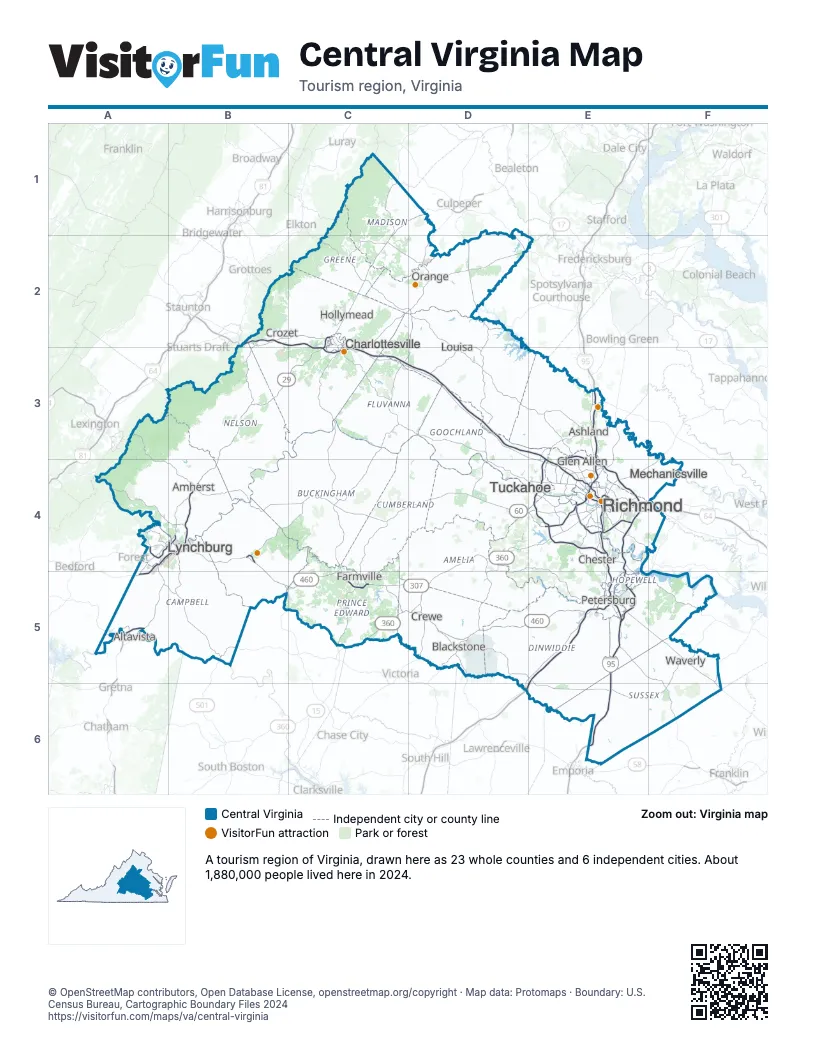
Highway index of Central Virginia
Each highway on the sheet and the grid squares it crosses.
- I-64B2, C2, C3, D3, E3, E4, F4
- I-85D6, E5, E6
- I-95E3, E4, E5, E6
- I-195E4
- I-295E3, E4, E5
- US 15C4, C5, D2
- US 29A4, A5, B3, B4, C1, C2, C3, D1
- US 33C2
- US 60C4, D4, E4
- US 250C2, C3
- US 360C5, D4, D5, E4, F3, F4
- US 460A4, A5, B4, B5, C5, D5, E5, F5, F6
- US 501A4, B4, B5
- VA 3D1, D2
- VA 6B3, C3
- VA 10E4, E5, F5
- VA 20C2, C3, C4, D2
- VA 22C2, C3
- VA 24B4, B5, C4
- VA 36E5
- VA 40B5
- VA 45C4
- VA 49D5
- VA 56B3
- VA 76E4
- VA 106F5
- VA 128A4
- VA 130A4
- VA 131B4
- VA 146E4
- VA 150E4
- VA 156E5, F5
- VA 163A4
- VA 195E4
- VA 210B4
- VA 230C2
- VA 231C2, D2
- VA 288E4
- VA 307C5, D5
- SR 647B4
- VA 895E4
- SR 7518E4
Things to do on the Central Virginia map
- American Civil War Museum
- Appomattox Court House National Historical Park
- Bear Creek Lake State Park
- Dabbs House Museum
- Edgar Allan Poe Museum
- Fort Harrison National Cemetery
- Fralin Museum of Art
- Hollywood Cemetery
- James Madison's Montpelier
- Kings Dominion
- Kluge-Ruhe Aboriginal Art Collection
- Lewis Ginter Botanical Garden
- Maggie L. Walker National Historic Site
- Metro Richmond Zoo
- Monticello
- Pamplin Historical Park
- Petersburg National Battlefield
- Richmond National Battlefield Park
- River Ridge Mall
- Science Museum of Virginia
- Stony Point Fashion Park
- The Valentine
- Twin Lakes State Park
- University of Virginia Cemetery and Columbarium
- Virginia Historical Society
- Virginia Holocaust Museum
- Virginia Museum of Fine Arts
- Virginia Randolph Cottage
- White House of the Confederacy
Places on the map
- Altavista
- Amherst
- Ashland
- Blackstone
- Charlottesville
- Chester
- Crewe
- Crozet
- Farmville
- Glen Allen
- Hollymead
- Louisa
- Lynchburg
- Mechanicsville
- Orange
- Petersburg
- Richmond
- Tuckahoe
- Waverly
Next to Central Virginia
© OpenStreetMap contributors, Open Database License, openstreetmap.org/copyright · Map data: Protomaps · Boundary: U.S. Census Bureau, Cartographic Boundary Files 2024