

Washington map
Lewis County map
About 87,049 people live here (Census Bureau, 2024 estimate). The sheet's index lists 300 streets; State Route 508, Main Street and Alder Street cross the most grid squares. Things to do inside the boundary: Centerville Western Stores, Chehalis-Centralia Railroad and Veterans Memorial Museum.
Open the map (PDF, US Letter)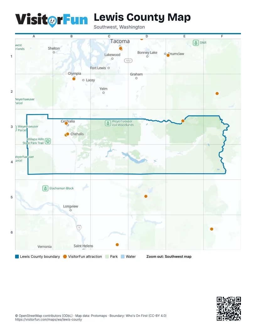
Maps inside Lewis County
1 map inside, from the street map of Lewis County down.
Street index of Lewis County
Each street on the sheet and the grid squares it crosses.
- State Route 7D3, D4
- US 12E3, F3, E4
- Morton RoadB4, D4
- 2nd StreetA3, D4
- State Route 508C3, B4, C4, D4
- Stevens Canyon RoadE3, F3
- Jackson HighwayB3, B4
- Highway 603B3, B4
- Forest Road 25D4, E4
- State Route 122C4
- Longmire-to-Paradise RoadE3
- Tucker RoadB4
- State Route 123F3
- State Route 506B4
- Main StreetA3, A4, B4, C4
- Cinebar RoadC3, C4
- Cooks Hill RoadB3
- Harrison AvenueB3
- Koontz RoadB4
- Main AvenueB4, D4
- Bishop RoadB3
- Rush RoadB3, B4
- Leonard RoadC4
- State Route 505B4
- North Pearl StreetB3
- SR 123F3
- Birley RoadC4
- Toledo-Vader RoadB4
- North National AvenueB3
- State Route 131E4
- West Main StreetB3, C4
- Airport RoadB3
- South Gold StreetB3
- North Tower AvenueB3
- Mossyrock Road WestC4
- South Market BoulevardB3
- Northeast Kresky AvenueB3
- Labree RoadB3
- Alder StreetB3, E3, A4, B4
- 7th StreetB4, D4
- South Tower AvenueB3
- Interstate AvenueB3
- South Pearl StreetB3
- Kresky AvenueB3
- Southeast Bucoda HighwayB3
- Mellen StreetB3
- West Cherry StreetB3
- West Forest Napavine RoadB4
- Downing RoadB3
- Northeast Washington AvenueB3
- Northwest Kerron StreetB4
- West 6th StreetB3
- Northwest Chamber of Commerce WayB3
- 2nd Avenue EastB4
- West Washington StreetB4
- Cowlitz LoopB4
- North Market BoulevardB3
- Southwest Parkland DriveB3
- Williams StreetB3, C4
- Ellsbury StreetB3
- Southwest 20th StreetB3
- Southwest 13th StreetB3
- North 5th StreetB4
- Cowlitz StreetB4
- 2nd Avenue NortheastB4
- BN Overpass NorthboundB3
- East Walnut StreetB3, B4
- BN Overpass SouthboundB3
- Northwest Pacific AvenueB3
- Ash StreetB4
- Southwest Birch AvenueB4
- West 4th AvenueA4
- West State StreetC4
- East Stella StreetB4
- East Washington StreetB4
- West Mellen StreetB3
- Northeast Cascade AvenueB3
- Kellogg WayB4
- Northwest Front StreetB3
- Northwest Park StreetB3
- Airport Road OverpassB3
- North Main StreetA4
- WA 123F3
- 5th Avenue EastB4
- Southwest Interstate AvenueB3
- State Route 507B3
- 5th Avenue NortheastB4
- Forest Road 52E3
- Centralia Alpha RoadB3, C3
- Forest Road 21E4, F4
- Forest Road 23E4
- Lincoln Creek RoadA3, B3
- King RoadA4, B4
- Spencer RoadB4, C4
- Wildwood RoadA4, B4
- Pleasant Valley RoadB3, D3, B4
- Bunker Creek RoadA3, B3
- Big Hanaford RoadB3
- Cline RoadE4
- North Fork RoadB3
- Pe Ell McDonald RoadA4
- Middle Fork RoadB3, C3
- Falls RoadD4
- Greenhorn RoadE4
- Little Hanaford RoadB3
- Ceres Hill RoadA3, B3
- Garrard Creek RoadA3
- Evans RoadB4, C4
- Silverbrook RoadE4
- Pinto RoadE4
- Winlock-Vader RoadB4
- South Military RoadB4
- Boistfort RoadA3, A4
- North Military RoadB4
- Salmon Creek RoadB4, C4
- Walupt Lake RoadF4
- Salzer Valley RoadB3
- Jackson Highway SouthB4
- South Scheuber RoadB3
- Gore RoadC4
- Burnt Ridge RoadC3, C4
- Peters RoadD4, E4
- Longbell RoadC4
- Forest Road 1260E3
- Jorgensen RoadC4
- Davis Lake RoadD4
- Green Mountain RoadC4
- Cannon RoadE3
- Champion Haul RoadD4
- Johnson RoadB3, C3, C4
- Gish RoadB4, C4
- Southwest Independence RoadA3
- Larmon RoadB4, C4
- Chandler RoadA3
- Anderson RoadB3, B4, D4
- Winston Creek RoadC4
- Meade Hill RoadD4
- Brockway RoadB3
- Eadon RoadB4
- Forest RoadD3, B4
- Oyler RoadB4
- Chambers Lake RoadF4
- Leudinghaus RoadA3
- Young RoadC4, E4
- Frost RoadB4
- West Avery RoadB4
- Twin Oaks RoadB3
- Curtis Hill RoadB3, A4, B4
- Schoen RoadC4
- Burchett RoadC4
- Brim RoadC4
- Smokey Valley RoadB4
- Flynn RoadC4
- River RoadA3, B3
- Meskill RoadA3
- Park RoadB4
- Meier RoadB4
- Jeffries RoadB3
- Penning RoadB3
- Tauscher RoadB3, B4
- Mandy RoadB4
- Shanklin RoadC4
- Chilvers RoadB3
- Rogers RoadB3, B4
- Telegraph RoadB4
- Perkins RoadC4
- Highland Valley RoadD4
- Frogner RoadB3, B4
- Newaukum Valley RoadB3
- Collins RoadB4
- Shorey RoadB3
- Drews Prairie RoadB4
- Larson RoadC4
- Knowles RoadB4
- Kirkland RoadB3, B4
- Rice RoadB3
- Boone RoadB4
- Forest Road 56F4
- Spooner RoadB3
- Graf RoadB3
- Ingalls RoadA3
- Mossyrock Road EastC4
- Classe RoadB4
- Mineral RoadD3
- Hamilton RoadB3, D4
- Lone Yew RoadB4
- Galvin RoadB3
- Coulson RoadB4
- Stowell RoadC4
- Hart RoadB4
- Northwest Airport RoadB3
- East Avery RoadB4
- Kiona RoadD4
- Skate Creek Road NorthE3
- Sargent RoadB4
- Northwest Louisiana AvenueB3
- Manners RoadA3
- Swofford RoadC4
- Blake RoadB4
- Glenoma RoadD4
- Bennett RoadB3, E4
- West Reynolds AvenueB3
- Doty-Dryad RoadA3
- Savio RoadD4
- East Forest Napavine RoadB3, B4
- Tune RoadB3
- Fuller RoadB3, C4
- Mineral Road NorthD3
- Henriot RoadB4
- Camus RoadB4
- Spears RoadE4
- Cowlitz Ridge RoadB4
- Isbell RoadC4
- Dieckman RoadB3
- Tooley RoadB4
- Gershick RoadC4
- Kjesbu RoadC4
- Blair RoadB3, C4
- Muller RoadA4
- Kangas RoadB4
- North Hamilton RoadB3
- Salkum RoadC4
- Stearns RoadB3
- Snyder RoadE3
- Valley RoadE3
- Westside HighwayB4
- North Gold StreetB3
- Fred Plant RoadC4
- Kehoe RoadE4
- Plomondon RoadB4
- Deggler RoadC3, C4
- Borst AvenueB3
- Maurin RoadB3
- Layton RoadB4
- Kennedy RoadC4
- Southwest William AvenueB3
- Mauerman RoadA4
- Northwest State AvenueB3
- East Main StreetB3, C4
- Fords Prairie AvenueB3
- Priest RoadD4
- Yew StreetB3
- North Washington AvenueB3
- Southwest Cascade AvenueB3
- West 1st StreetB3
- Southwest Riverside DriveB3
- Marion StreetB3
- Skate Creek Road SouthE3
- Kosmos RoadD4
- Meyer RoadA4, D4
- Scheuber Road NorthB3
- Mount Vista RoadB3
- Southwest McFadden AvenueB3
- Eshom RoadB3
- Imboden RoadB4
- Ives RoadB3
- Stevens RoadA3
- Chapman RoadD4, E4
- 3rd StreetA3, A4, D4
- West 4th StreetB3
- Woodland AvenueB3
- Centralia College BoulevardB3
- South 3rd StreetA4, B4
- Uden Road EastD4
- Long RoadB3
- Military RoadB3
- Southwest 16th StreetB3
- Southwest Snively AvenueB3
- Kernahan Road EastE3
- Carlisle AvenueC4
- Belmont AvenueB3
- Ajlune RoadC4
- Southwest Salsbury AvenueB3
- Northwest West StreetB3
- South StreetB3
- Scammon Creek RoadB3
- Berry Patch RoadF4
- Mossyrock AvenueC4
- Barnes DriveB4
- Fluckinger RoadB4
- Gharet RoadE4
- East State StreetC4
- Lum RoadB3
- East Summa StreetB3
- Southwest Newaukum AvenueB3
- East Pe Ell AvenueA4
- West Summa StreetB3
- South Washington AvenueB3
- Village RoadC4
- East Floral StreetB3
- Southwest Kerron StreetB4
- Tilley AvenueB3
- Parnell RoadC4
- Kindle RoadE4
- Allen AvenueB3
- Northwest Fir StreetB4
- La Bree RoadB3
- Haviland StreetB3
- East Union StreetB3
- Northwest Cascade AvenueB3
Things to do on the Lewis County map
Places on the map
- Abandoned Tono Coal Mine
- Bear Prairie
- Blue Lake
- Centralia
- Chehalis
- Chehalis River
- Chehalis-Centralia Airport
- Davis Lake Wildlife Area
- Dumbbell Lake
- Fords Prairie
- Fort Borst Park
- Glacier Lake
- Ike Kinswa State Park
- Iron Creek Campground Loop
- Kiona Creek Wildlife Area
- Kosmos Wildlife Area
- La Wis Wis Campground
- Lake Scanewa
- Lewis and Clark State Park
- Lewis County Fire District 1
- Lewis County Fire District 10
- Lewis County Fire District 11
- Lewis County Fire District 13
- Lewis County Fire District 14
- Lewis County Fire District 15
- Lewis County Fire District 16
- Lewis County Fire District 17
- Lewis County Fire District 18
- Lewis County Fire District 2
- Lewis County Fire District 3
- Mayfield Buffer Wildlife Area
- Mossyrock Wildlife Area
- Pe Ell South
- Peterman Ridge Wildlife Area
- Riffe Buffer Wildlife Area
- Tahoma State Forest
- Tatoosh Wilderness
- WA State DNR
- Weyerhaeuser Vail Woodlands
- Willapa Hills State Park Trail
Next to Lewis County
- Bonney Lake map
- Enumclaw map
- Fort Lewis
- Graham
- Lacey map
- Lakewood map
- Longview map
- Olympia map
- Shelton
- Tacoma map
- University Place map
- Yelm
© OpenStreetMap contributors, Open Database License, openstreetmap.org/copyright · Map data: Protomaps · Boundary: Who's On First (CC-BY 4.0); Quattroshapes (CC BY 2.0)















