

Arkansas map
Garland County map
About 99,902 people live here (Census Bureau, 2024 estimate). The sheet's index lists 300 streets; Albert Pike Road, Airport Road and Gladstone Forest Road cross the most grid squares. Things to do inside the boundary: A Narrow Escape, Adventureworks and Arkansas Alligator Farm & Petting Zoo.
Open the map (PDF, US Letter)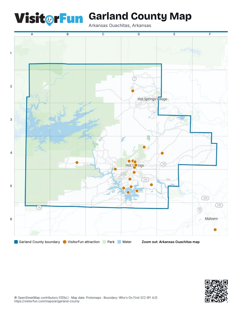
Street index of Garland County
Each street on the sheet and the grid squares it crosses.
- East Grand AvenueD4, E4, F4
- Doctor Martin Luther King, Junior ExpresswayE4, C5, D5, E5
- Hot Springs BypassE4
- Albert Pike RoadA4, B4, C4, D4, C5, D5
- Airport RoadA5, B5, C5, D5, A6
- Park AvenueE3, D4, E4
- Central AvenueD4, D5, C6, D6
- Malvern AvenueD4, D5, E5
- Malvern RoadE5
- Higdon Ferry RoadD5
- West Grand AvenueD4
- Hobson AvenueD4
- Summer StreetD4, D5
- 3rd StreetD4, D5
- Pakis StreetD5
- US 70C5
- Spring StreetD4, E4, F4
- Mountain Pine RoadC3, C4
- Amity RoadC5, D5, B6, C6
- Lonsdale Cutoff RoadE3, F3, F4
- West Strawberry RoadC3, D3, C4
- Sunshine RoadB4, B5, C5
- Desoto BoulevardD2, E2, D3, E3
- Carpenter Dam RoadD5
- Tiger Mountain RoadF4
- Westinghouse DriveD4, E4, D5, E5
- Gorge RoadD4
- Jack Mountain RoadD6
- Section Line RoadD5
- Cockrill StreetF4
- Point Cedar RoadB6
- Werner StreetD5
- Lonsdale RoadE5
- StraussF4
- North Westinghouse TerraceE4
- Broadway BridgeD4
- Bridge StreetD4
- Old Hot Springs HighwayE3
- Beaudry CircleD2
- Mill Creek RoadE3, D4, E4
- Old Dallas RoadA5, B5
- Barcelona RoadD2, E2, D3
- Timberlake DriveB4, C4, B5, C5
- Caddo Gap RoadA5, B5
- Ragweed Valley RoadA4, B4, A5
- Marion Anderson RoadC5
- Shady Grove RoadD4, D5, E5
- Owl Creek RoadB4
- Brady Mountain RoadB3, B4
- Lakeshore DriveC5, D5
- Pearcy RoadB5, B6
- East Main Haul RoadD2, E2
- Blakely Dam RoadB4, C4
- Blacksnake RoadC4, D4
- South Moore RoadC5, C6
- Hamilton Dairy RoadD3, E3
- Fresno RoadD2, E2, D3, E3
- Treasure Isle RoadC4
- Oak Grove RoadB4, B5
- Mazarron DriveD3, E3
- Meyers Creek RoadA4, A5
- Whittington AvenueD4
- Crystal Hill RoadC4
- Danville RoadE3
- Cortez RoadD2, E2
- Ridgeway StreetD4, D5
- Thornton Ferry RoadC4, C5
- Albright RoadC5, D5
- Balboa DriveE3
- Lake Ouachita TrailC3
- Camino RoadD3
- Lakeside RoadD5
- Golf Links RoadD5
- Burchwood Bay RoadC5, D5
- Ponce de Leon DriveE3
- Twin Points RoadC5, D5
- Catherine Park RoadE5
- 7th StreetD4, D5
- Balearic DriveE3
- Carmona RoadD2
- Bull Bayou RoadC4
- Richard StreetD4, D5
- Monterrey RoadD3, E3
- Woodlawn AvenueD5
- East Villena DriveD3
- Balearic RoadD3, E3
- Convention BoulevardD4
- Santa Maria RoadD2
- McFadden RoadC3
- Hughes RoadC4
- Clearcreek RoadC4
- Carmona DriveD2, D3
- Toledo DriveD2
- McLeod StreetD5
- Hollywood AvenueD5
- Crescent AvenueD4
- Adam Brown RoadB5, C5
- Ouachita AvenueC4, D4
- Greenwood AvenueD4
- West Saint Louis StreetD5
- Panama StreetD5
- Chattanooga StreetD4
- Emory StreetD5
- Television Hill RoadD5
- Calella RoadD2
- Aviation PlazaC5, D5
- Alicante RoadD2, D3
- West Villena DriveD3
- Westpine DriveC4
- Silver StreetD4
- Timberlake RoadC5
- Tucker CircleB6
- Asturias DriveD3, E3
- Fontana RoadD5
- Valley StreetD4
- Cypress StreetD4
- Winans AvenueD5
- West Belding StreetD4
- North Mission StreetD4, D5
- Cooper StreetD4, D5
- Honeycutt StreetD4
- Wynn StreetD5
- Clear Creek RoadC4
- Market StreetD4
- Reserve StreetD4
- Huelva RoadD3
- East Maurice StreetD4
- Temperance Hill RoadD5
- Crawford StreetD5
- Woodfin StreetD4
- South PersimmonD4
- Lead StreetD4
- Balboa RoadE3
- Willow StreetD4
- Ponce de Leon RoadE3
- Gladstone Forest RoadA1, B1, C1, A2, B2
- West Main Haul RoadC2, D2, C3
- Cedar Creek RoadE4, F4
- West Glazypeau RoadC3, D3, C4
- Walnut Valley RoadC3, D3, C4
- Glazypeau Mountain RoadD3
- Little Blakely Creek RoadC2, D2, C3, D3
- Buckville RoadA2, B2, A3
- Drybranch RoadC2, C3
- Royal Oak RoadC3, D3, C4
- Lake Winona RoadD1, E1, D2
- Tabor Mountain RoadA2, B2
- Bill Myers RoadD2, D3
- Cedarglade RoadC4, D4
- Old Bear RoadB4, C4
- Hickorynut Mountain RoadA4
- Buffalo Gap RoadC2, D2
- East Goathill RoadD3
- South Crystal Springs RoadA4, A5
- Treece RoadC3
- Ravine TrailD6, E6
- Nubbin Ridge RoadA5, B5
- Old Brushy Mountain RoadC1, C2
- Tramway RoadC2, C3
- Muse Creek RoadA2
- Boxley RoadC3
- Chrysalis RoadB3
- North Moore RoadB5, C5
- Bearcat Hollow RoadD4
- Speers CircleC2
- Breshears RoadD3, D4
- Lake Rix RoadD3, C4, D4
- Savall CircleC2
- Sleepy Valley RoadD4
- South Harris RoadB5, B6
- West Mountain DriveD4
- Hardy Garner RoadE3
- Deerpark RoadE3, E4
- Ten Mile RoadE4
- Fox Pass CutoffD3, D4
- Joshua CircleB2
- Rock Springs RoadB2, B3
- Promise Land DriveD4, E4
- Owl Creek CutoffB4
- Lost Creek RoadB5
- Warren Watson RoadD3
- Minton RoadA3, B3
- Oglesby RoadD2
- Bald Mountain RoadE4, D5, E5
- Bearcreek RoadB1, B2
- Umetco RoadsE5
- Camp Story RoadA3
- North Crystal Springs RoadA4
- Ault LoopE3
- Oates LoopD2
- Peaceful Valley RoadD3, D4
- Rock Creek RoadC5
- Miles Clearcut TrailB5, C5
- Poulan TrailD3, D4
- Little Gentry LoopE4
- Travis CircleC2
- Eagle Eye RoadC3
- East Glazypeau RoadD3
- Diamondhead DriveE5
- Fleetwood DriveC4
- Tena Herron RoadB2
- Rabbit Creek RoadC4
- Randall RoadC5
- Newkirk CircleD2
- Caldwell RoadB3
- Brookhill Ranch RoadD3
- Weyerhaeuser ComplexC4
- Yukon PassA5, A6
- Magic Forest RoadE4, F4
- Sundown Mountain RoadD6
- Saugey RoadE4
- Pittman RoadC5
- High Lead RoadC3
- Cozy Acres RoadC4
- Vaughn RoadE3
- Wasp RoadC2, D2
- Kilovolt RoadD2
- Oakbutte RoadD1, E1, D2
- Akers RoadE5
- Hammock RoadC2, D2
- Highwater Hill RoadC3
- Forestridge RoadB5
- Sangster LaneE4
- Wildcat RoadD4
- Pyrenees WayD3
- Old Dove RoadC3
- Rifle Range RoadB2
- Apple RoadA6
- Huddleston Springs RoadC4
- Eddie Whish RoadD3
- Frankie RoadE4
- Brushy Mointain RoadC1, C2
- Grandstaff DriveD5, E5
- Cedar Fourche RoadB2, B3
- Albert Graves RoadC2
- Broken Tree TerraceD4
- Powell Mountain RoadA1
- Rigsby LoopF4
- Charlie Stover RoadC5
- Bucktine TrailB1, B2
- Rouse Creek RoadB4
- Hickory Ridge RoadC2
- Dunn RoadD3
- McClendon RoadD4, E4
- Brushycreek RoadD2
- Whitfield RoadB5
- Decoy RoadC2
- O Neal RoadE6
- West Goathill RoadD3
- Shady Heights RoadD5, E5
- Boxley TerraceC3
- Elkhorn LoopC4
- Forest RoadD3, C4, D4, E4, E5
- Jimmie Scott RoadA3
- Mollie RoadC2
- Castano DriveD3
- Wildhorse RoadB4, B5
- Winkler RoadB5, C5
- Nesbit CircleE4
- Summit Ridge CircleF4
- Vanderslice RoadB2, C2
- Log House RoadE4
- Cones RoadD4
- Lockett Mountain RoadD3
- Red Oak Cut OffD5
- Calico RoadB4, B5
- Roxanne RoadE3, E4
- Little Blakely TrailC3
- Crawdad Island RoadC3
- Theobalt RoadE4
- Ponyboy RoadB1
- Brookhill Ranch TrailD3
- Denise LaneE4
- Immanuel DriveD4
- Belvedere DriveD4
- Blakely RoadD2
- Gold Nugget LoopC4
- Mount Riante RoadC6
- Bryant RoadD3, D4
- Wild Boar TrailC3
- Empire TrailD3, D4
- Main StreetC4, D4, D5
- Old Brundage RoadC5
- Spike RoadC3, D3
- Flower Garden TrailE3
- Quail Flush RoadC2
- Warner RoadB6
- Music Mountain RoadC4
- Canyon Springs CircleB5
- Surrey RoadD3
- Ford RoadB5
- Ohio DriveE5
- Leonard StreetD5
- Rush Fork RoadC5, C6
- Weston RoadC5
- Quarry Valley RoadE4
- Stratcor RoadsE5
- East Strawberry RoadD2, D3
- Pleasant Run RoadF4
- Tower TrailD3
Things to do on the Garland County map
- A Narrow Escape
- Adventureworks
- Arkansas Alligator Farm & Petting Zoo
- Bathhouse Row
- Buckstaff Bathhouse
- Crystal Ridge Distillery
- Dryden Pottery
- Fox Pass Pottery
- Funtrackers Family Fun Park
- Garvan Woodland Gardens
- Historic Malco Theatre
- Hot Springs Gallery Walk
- Hot Springs Marina
- Hot Springs Mountain Tower
- Hot Springs National Park
- Hot Springs Off-Road Park
- Hot Springs Trolleys
- It's About Rocks
- Machine Gun Grotto
- Magic Springs Theme and Water Park
- National Park Duck Tours
- Oaklawn Racing Casino Resort
- Retroverse Museum
- Ron Coleman Mining
- Sunbay Resort
- The Golf Shack
- The Purple Cow
- The Wharf Resort
- The Winery of Hot Springs
- TNT Fun Play
- Wake Zone
Places on the map
- Arkansas Twister
- Arlington Lawn
- Balboa Golf Course
- Barton Mountain
- Bathhouse Row
- Benoit Airfield
- Big Lake
- Blowout Mountain
- Catherine's Landing
- Cedar Glades Park
- Charlton Recreation Area
- Checkerboard Island
- CHI St. Vincent Hot Springs
- CHI St. Vincent Hot Springs Rehabilitation Hospital
- Cortez Golf Course
- DeSoto Golf Course
- Electric Island WMA
- Fountain Lake
- Garvan Woodland Gardens
- Hot Springs
- Hot Springs Country Club
- Hot Springs Mall
- Hot Springs National Park
- Hot Springs Reservoir
- Hot Springs Village
- Jessieville Visitor Center and Work Center
- Lake Catherine
- Lake Desoto
- Lake Hamilton
- Lake Ouachita State Park
- Lake Pineda
- Lonsdale
- Magellan Golf Course
- Magic Springs Theme & Water Park
- Mountain Pine
- National Park Medical Center
- Oaklawn
- Piney
- Rockwell
- Whittington Trail
Next to Garland County
- Malvern
© OpenStreetMap contributors, Open Database License, openstreetmap.org/copyright · Map data: Protomaps · Boundary: Who's On First (CC-BY 4.0); Quattroshapes (CC BY 2.0)