

California map
San Diego-Chula Vista-Carlsbad Metro Area map
The sheet's index lists 21 highways; I-5, I-8 and I-15 cross the most grid squares. Things to do inside the boundary: Anza-Borrego Desert State Park, Balboa Park and Barona Resort & Casino. Also on it: Alpine, Borrego Springs and Carlsbad.
Open the map (PDF, US Letter)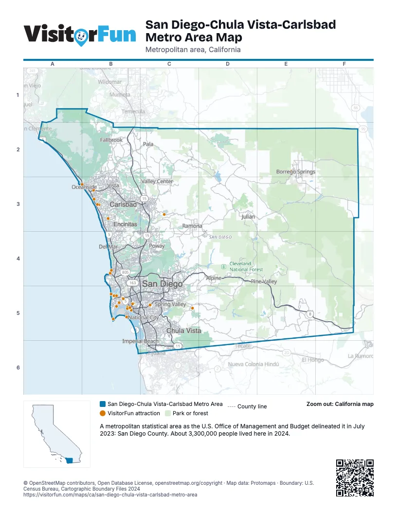
Highway index of San Diego-Chula Vista-Carlsbad Metro Area
Each highway on the sheet and the grid squares it crosses.
- I-5A2, A3, B3, B4, B5, C5, C6
- I-8B5, C4, C5, D4, E4, E5, F5
- I-15B2, B3, B4, B5, C3, C4, C5
- I-805B4, B5, C5, C6
- US 80C5
- US 101B5, C5
- US 395B5, C3, C5
- CA 11C6
- CA 15B5, C5
- CA 52B4, C4
- CA 54C5
- CA 56B4, C4
- CA 67C4
- CA 75B5, B6, C6
- CA 76B2, B3
- CA 78B3, C3
- CA 94B5, C5, D5
- CA 125C4, C5, C6
- CA 163B4, B5
- CA 188D5, D6
- CA 905C6
Things to do on the San Diego-Chula Vista-Carlsbad Metro Area map
- Anza-Borrego Desert State Park
- Balboa Park
- Barona Resort & Casino
- Bazaar Del Mundo
- Belmont Park
- Big Blue Photo Boat
- Birch Aquarium at Scripps
- Broken Yolk Cafe
- Cabrillo National Monument
- California Watersports
- Casa de Bandini
- Ciné Café
- Cruise San Diego
- Fashion Valley
- Fiesta de Reyes
- Gaslamp BBQ
- Harrah's Resort Southern California
- Highway 94 Wine Trail
- Hotel del Coronado
- Liberty Public Market
- Maritime Museum of San Diego
- Museum of Making Music
- Navy SEAL Museum San Diego
- Oceanside Adventures
- Old Town San Diego
- Old Town San Diego State Historic Park
- Old Town Trolley Tours of San Diego
- Pala Casino Spa Resort
- Parkway Plaza
- Petco Park Tour
- Ringer's Roller Rink
- San Diego Model Railroad Museum
- San Diego Natural History Museum
- San Diego Watercolor Society Gallery
- San Diego Whale Watch
- San Diego Zoo
- San Diego Zoo Safari Park
- Seaport Village
- SeaWorld San Diego
- Spanish Village Art Center
- Surf Diva
- Sycuan Casino Resort
- The Old Globe Theatre
- Torrey Pines State Natural Reserve
- USS Midway Museum
- Viejas Casino & Resort
- Weekend Outside
- Westfield UTC
- Whaley House Museum
- Wild Pacific Whale Watch
Places on the map
- Alpine
- Borrego Springs
- Carlsbad
- Chula Vista
- Del Mar
- Encinitas
- Fallbrook
- Imperial Beach
- Julian
- National City
- Oceanside
- Pala
- Pine Valley
- Poway
- Ramona
- San Diego
- Spring Valley
- Valley Center
- Vista
© OpenStreetMap contributors, Open Database License, openstreetmap.org/copyright · Map data: Protomaps · Boundary: U.S. Census Bureau, Cartographic Boundary Files 2024